|
Research Notes
 Map Group BOWLES 1763
|
 |
|
Bowles 1763
|


|
|
|
Modern Map of Hamp Shire ie Hampshire, scale about 7 miles to 1 inch,
published by Carington Bowles, St Paul's Churchyard, and Robert Sayer, Fleet
Street, London, after 1763.
|
|
The map is a new engraving probably copied from the map by Thomas Kitchin,
published by R and J Dodsley, Pall Mall, London, 1763-64. |
|
The map was
studied from a good quality scanned image (200dpi) sent with an
email enquiry asking for an identification.
|
|
The map size, measured from the image: wxh, map = 247x189mm.
|
 |
MAP FEATURES |
 |
ITEMS in the Collection |
 |
|
|
The map is a close copy of the map by Thomas Kitchin,
published 1763-64. Putting the maps side by side, they 'look' the
same. The Bowles and Sayer map is a new engraving, with new title
cartouche and imprint, and differences in detail, in particular
the engraving of placename labels. Map features will not be
described in directly, but by comparison with the features of the
Kitchin map:-
|

|
Kitchin 1763
|
|
NB: it is an assumption that Bowles and Sayer copied Kitchin;
perhaps the copying was the other way around, or both copied from
something else.
|
|
The Bowles and Sayer map is nicely tinted, which might have
been done at any time from the printing of the map to the
present.
|

| top of page |
 |
|
| MAP FEATURES |
|
title
monumental cartouche
map maker
|
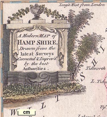
Kitchin's baroque cartouche is replaced by an equally
fashionable monumental cartouche, carved with drapes, with urn,
leaves and trees, upper left:-
A Modern MAP of HAMP SHIRE, Drawn from
the latest Surveys Corrected & Improv'd by the best
Authorities.
Printed at the bottom is a new imprint:-
Printed for Carington Bowles in St.
Pauls Churchyard, & Robt. Sayer in Fleet Street.
|
orientation
compass rose
|
Same as Kitchin; but tinted.
|
scale line
scale
|
Same as Kitchin; but tinted. The scale line was measured from
the map, the 10 miles = 37.5 mm gives a scale 1 to 429158
assuming a statute mile. The map scale is about:-
1 to 430000
7 miles to 1 inch
|
lat and long scales
lat and long grid
|
Same as Kitchin; but tinted, the chequers in blue. If you look
closely at the four corners there are tiny differences in
coverage, as if the map borders are shifted slightly. Also notice
an error in the bottom scale, the 0d 30m mark and label are 5
minutes out of position.
|
table of symbols
|
Almost the same as Kitchin. The words are the same but
lettering size is larger, with consequent changes in layout.
|
sea area
sea plain
sandbanks
|
Same as Kitchin (as far as I can see); sand banks tinted.
|
coast line
coast shaded
headlands
|
Same as Kitchin (as far as I can see).
|
coastal defence
castles
fortifications
|
Same as Kitchin.
|
rivers
ponds
bridges
|
Same as Kitchin; broader parts of rivers tinted.
|
relief
hillocks
|
The hillock symbols on the Bowles and Sayers map are slightly
larger, and slightly more numerous? than on the Kitchin map; the
hillocks are tinted.
The hillocks give no better impression of the shape of the
county, and appear, as on many maps, just to be filling space!
The overall impression could even be judged to be misleading.
|
beacons
|
Popham Beacon is labelled, as on Kitchin's map, but the symbol
is changed from hamlet to village.
|
woods
forests
trees
|
Much the same as Kitchin; woodland areas tinted.
|
parks
|
Much the same as Kitchin; interiors tinted. There might be
differences of interior detail.
|
county
|
Much the same as Kitchin; but tinted. The boundaries are
emphasised by a tint along the line, plus a paler wash into the
adjacent county area; Dorset green, Wiltshire red, Berkshire
green, Surrey red, Sussex green.
|
settlements
|
Much the same as Kitchin. Notice that the labelling is not
always in the same position.
|
roads
|
Same as Kitchin (but I have not checked thoroughly).
|
|
Winchester Area
|
|
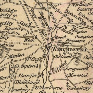
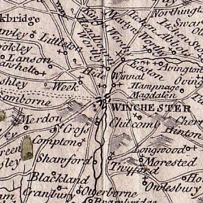
Looking at a 10 mile by 10 mile square centred on Winchester
it is possible to compare the Bowles and Sayer map with the
Kitchin map.
|
|
|
| Bowles and Sayer | Kitchin |
 |
 |
|
rivers
|
Same as Kitchin.
|
relief
hillocks
|
Both maps use hillocks engraved with shading to the east.
Bowles's hillocks are larger and a little more numerous. Their
tinting is crude and doesn't clarify anything. Magdalen Down has
lost its hillocks; the downland to the west of Winchester have
gained some. Some of Bowles's hillocks interfere with other
features.
|
parks
|
Parks are the same shape, an outline with fence palings. On
the Bowles and Sayer map Hursley Park has fewer trees, and is
tinted.
|
settlements
|
The same places are marked and labelled on each map. The
orientation of the symbols and the placement of labels is
different; the spelling appears to be identical.
Kitchin's treatment of Winchester is not copied on the Bowles
and Sayer map, perhaps, like us, they didn't understand what
Kitchin meant.
|
roads
|
Exactly the same as Kitchin.
|

| top of page |
 |
|
|
also see:-
|
|

|
related map group -- Kitchin 1763
|
 |
|
|
ITEMS |
in HMCMS Map Collection and Private Collections (scanned item in bold)
|

|
private collection (27) -- map
|

| top of page |
|
 |
All Old Hampshire Mapped Resources |

 Map Group BOWLES 1763


