
 Map Group JOHNSON 1907


VOL. 1 With 174 Illustrations. ROADS MADE EASY By Picture and Pen. Compiled by CLAUDE JOHNSON. Edited by LORD MONTAGU.
LONDON: THE CAR ILLUSTRATED, LTD., 168, PICCADILLY, W.
'THE CAR' Founded and Edited by LORD MONTAGU.
WHAT IT IS! A Weekly Pictorial Record of the World's Automobilism and Travel.
WHAT IT DOES!! Records and Illustrates all the latest Motoring News, the latest Types of Cars, the latest Improvements, and the most interesting places to visit.
WHAT IT WILL DO!!! 'The Car's' PUBLISHING DEPARTMENT will supply Motor Publications of all kinds and Motor Maps and Guides of all Countries. 'The Car's' INFORMATION BUREAU will give complete information upon every conceivable question relating to Motoring, Choice of Car, Disposal of Car, Drivers, Tours, &c. 'The Car's' INSURANCE DEPARTMENT will Insure a Car against all risks anywhere, and will include Free Subscription to 'THE CAR' where the premium is not less than L7 7s. (See advt. page at end.)
Price 6d. Weekly. ... Offices 168, PICCADILLY, LONDON, W. ...
ROADS MADE EASY BY PICTURE AND PEN COMPILED BY CLAUDE JOHNSON EDITED BY LORD MONTAGU VOL.1
LONDON: THE CAR ILLUSTRATED, LTD., 168, PICCADILLY. 1907.


Facing the preface is a fold out Index Map of the routes in the south of England. All this shows, on an outline of the country, are the routes described with a limited number of place names; each route has a number referring to the its outward and return itineraries.
The preface describes the 'system' used for the itineraries.
PREFACE.
There are many excellent guide and road books already in existence, but few of these have been issued since touring in motor-cars has become general, and therefore they often lack the special points which are useful in a new form of travelling. In fact new methods of road travel demand a new system of road indication. The pedestrian and cyclist often welcome a stop for a moment or two at a point where two roads meet, not only in order to leisurely consult their route book but to rest awhile. Many of the route directions in existing road books, such as instructions to 'turn to the right of St. Mary's Church,' essentially require that the traveller should make enquiries locally as to the existence or situation of the landmarks which are to be his guide. The motorist nearly always resents delay. When faced by two roads he sometimes, indeed, prefers to take one at random rather than stop his career even for the brief moment necessary to carefully examine a direction-post or make an enquiry. I do not say that such haste and hurry is in any way admirable, but it must be reckoned with in the guide books of the future.
'The Road Made Easy with Picture and Pen' is intended to enable the motorist to find his way over the great majority of the main roads of England and Wales without the necessity of reading direction-boards in detail or making enquiries which are often half heard or wholly misunderstood.
In the system suggested and here carried into effect by Mr. Claude Johnson, endeavour is made to inform the motorist as to the roads before him in clear and unmistakeable language, and, by means of a graphic description of landmarks, assisted in many cases by actual photographs, to pre-inform him of exactly what he has to do when he arrives at the end of any particular section of road.
In the first edition of an ambitious work of this kind mistakes may be discovered which are unavoidable in any first attempt dealing with a complicated mass of details, and it is hoped that motorists who make use of the book and who discover any errors will kindly communicate with the Editor for the benefit of the motoring community at large.
It should be noted that no distinction is made between telegraph and telephone wires.
It must not be thought that, because here and there cautions are given concerning particular dangerous portions of the road, any attempt has been made to inform the user of this book of all the points which are dangerous.
...


ABBREVIATIONS.
[large bold R] = Right.
[large bold L] = Left.
[large bold S O] = Straight on.which are used in the itinerary text. And more symbols which are used in the left margin of sections of text and supplement the text:-
F.T.W. [drawing of poles and wires] = Follow the Telegraph Wires.
[large V, right arm bold] = At fork take Right.
[large V, left arm bold] = At fork take Left.
[bold upright line, light cross line] = At Cross Roads, keep Straight on.
[light upright, bold cross line to right at head] = Turn Right.
[light upright, bold cross line to left at head] = Turn Left.
System
follow the telegraph wires
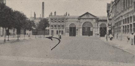
... and, in front, a building with three arches
fork ... small cottage, with red-tiled roof, and pillar-box in wall stands ...
... pass under railway bridge ...
... a shop marked, 'Library, H. J. KNOWLES.'


CONTENTS.
Route 1. -- London via Staines, Basingstoke, Andover, Salisbury, Yeovil, Exeter, Okehampton, Launceston, Truro, Penzance to Land's End - - [page] 1
Reverse of Route 1. - - 19
...
Route 4. -- London via Andover, Warminster, Frome, Glastonbury to Bridgwater - - 43
Reverse of Route 4 - - 48
Route 5. -- London via Kingston, Guildford, Godalming, Hindhead, Petersfield to Portsmouth and Southsea - - 53
Reverse of Route 5 - - 58
Route 6. -- London via Guildford, Hog's Back, Farnham, Alton, Alresford to Winchester - - 63
Reverse of Route 6 - - 65
Route 7. -- London via Basingstoke, Winchester to Southampton - - 68
Reverse of Route 7 - - 70
Route 8. -- London via Winchester, Romsey to Cadnam Corner - - 72
Reverse of Route 8 - - 74
Route 9. -- London via Cadnam Corner, Lyndhurst, Christchurch to Bournemouth - - 76
Reverse of Route 9 - - 77
Route 10. -- London via Cadnam Corner, Ringwood, Christchurch to Bournemouth - - 79
Reverse of Route 10 - - 82
Route 11. -- London via Ringwood, Wimborne, Wareham to Weymouth - - 84
Reverse of Route 11 - - 86
...
Route 25. -- London via Winchester and Beaulieu to Lymington - - 177
Reverse of Route 25 - - 179
Route 26. -- London via Lyndhurst to Lymington - - 181
Reverse of Route 26 - - 182
Route 27. -- London via Winchester, Redbridge, Totton to Lyndhurst - - 183
Reverse of Route 27 - - 185
The routes in the road book which are relevant to Hampshire are listed below in more detail, using similar journey nodes to those in other route descriptions:-
route 1 - London to Lands End - from London; through Staines, Middlesex; Bagshot and the Jolly Farmers, Surrey; then Blackwater, Hartfordbridge, Basingstoke, Whitchurch, Andover, Andover, Middle Wallop, Hampshire; Lopcomb Corner and Salisbury, Wiltshire; and west to Exeter, Devon; and Lands End, Cornwall.The part of this route which is in Hampshire is transcribed below.
route 4 - London to Bridgwater - from Andover, Hampshire; through Amesbury, Wiltshire; and west to Bridgwater, Somerset (connects to routes to Exeter, Devon etc; but not continued to Barnstaple, Devon).
route 5 - London to Portsmouth - from London; through Godalming, Surrey; then Liphook, Petersfield, Horndean, Cosham, to Portsmouth, Hampshire.
route 6 - London to Winchester - from Guildford through Farnham, Surrey; then Alton, Alresford, to Winchester, Hampshire.
route 7 - London to Southampton - from Basingstoke, through Popham Lane, Winchester, to Southampton, Hampshire.
route 8 - London to Cadnam Corner - from Winchester, through Romsey, to Cadnam Corner, Hampshire.
route 9 - London to Bournemouth - from Cadnam Corner, through Lyndhurst, Hampshire; then Purwell Corner, Christchurch, to Bournemouth, Dorset. (Poole is ignored.)
route 10 - London to Bournemouth - from Cadnam Corner, through Ringwood, Hampshire; then Purwell Corner, Dorset (and continue as route 9)
route 11 - London to Weymouth - from Ringwood, Hampshire; then to Weymouth, Dorset.
route 25 - London to Lymington - from near Southampton, through Redbridge, Beaulieu, to Lymington, Hampshire.
route 26 - London to Lymington - from Lyndhurst, to Lymington, Hampshire.
route 27 - London to Lyndhurst - from near Southampton, through Redbridge, to Lyndhurst, Hampshire.


ROUTE 1.
LONDON via Staines (16 1/2), Basingstoke (45 3/4), Andover (63 1/2), Salisbury (81 1/4), Yeovil (122 1/2), Exeter (169 1/2), Okehampton (191 3/4), Launceston (210 1/2), Truro (256 3/4), Penzance (282), to LAND'S END (292).
Enter Hyde Park by the gates towards which the statue of Wellington faces,
then ...
... ...
... ...
3 miles onward the 26th mile stone from London will be noticed on L. Proceed slowly down the hill which follows. At its foot swing round to R into Bagshot village.
Keep straight through Bagshot and towards the end of it, after passing the 'Fighting Cocks Inn' on R, the 'Hero of Inkerman' sign will be seen standing in the middle of a fork.
Here keep to the L of the sign, and follow the telegraph wires.
Then follows an ascent, and a bend to the R brings into view a long, straight ascent at the head of which is a fork, in the middle of which stands the 'Jolly Farmers Inn,' having its sign standing on a triangular green.
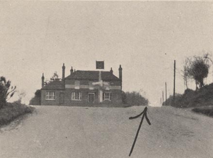
Here take R
The 29th mile stone from London is at Camberley. Keep S O through Camberley and thus to
Blackwater level railway crossing (30 3/4 miles from London). This should be carefully approached.
Following the level crossing is a slight rise, cross roads, and a fork.
Here keep L up an ascent on to a long, quite straight stretch of level road, across a fine open heath (Hartford Bridge Flats). This is followed by woods, a caution board on the R and a descent to a hidden cross road. (Hartford Bridge Village.)
After the 37th mile stone from London, oak trees will be noticed planted in an orchard-like fashion on the green on each side of the road. Here prepare for an important fork. Thus:-
After passing the 'Phoenix Inn' on L and a small pond on R
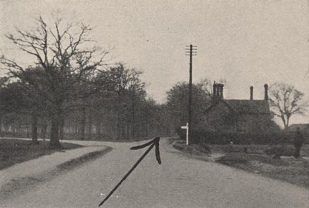
at fork take R past a red-brick cottage with red-brick chimneys.
At Hook, after the 39th mile stone from London, on passing the 'White Hart Hotel,' an old coaching inn with projecting porch supported by pillars over entrance to yard,
bear R
After passing the 40th mile stone from London, at a spot where road forks either side of a triangular green,
bear L and proceed over railway bridge
Then follow the telegraph wires to Basingstoke (45 3/4 miles from London).
After passing Basingstoke market place on R, keep a look out for a fork marker by a signpost (over which there is a lamp) which stands in front of a shop marked, 'Library, H. J. KNOWLES.'
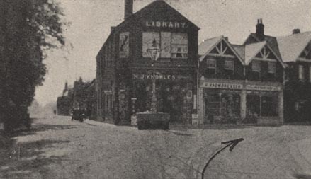
At this fork take R for Andover.
The road cannot be mistaken for 5 1/2 miles, where, at 'Deane Gate Inn.' keep S O and do not take L.
After passing through two villages (Overton and Laverstoke) from the top of a hill 5 miles beyond Deane Gate will be seen a village. There are red-brick villas on the L and thatched roofs may be seen in the valley below.
This is Whitchurch
At the foot of the hill in Whitchurch the 'White Hart Inn' stands on the R.
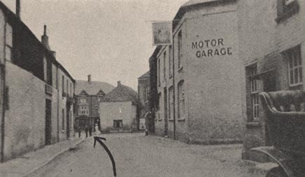
Almost facing the traveller is a red-brick building with a clock.
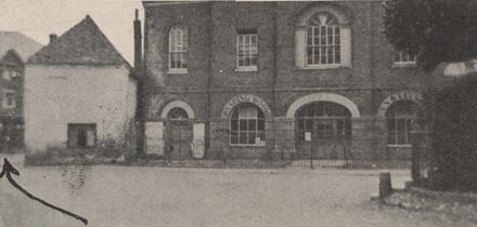
Here bear slightly to the L
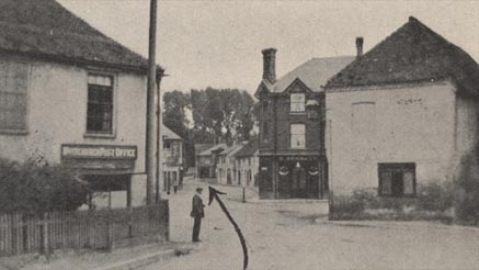
across the cross roads and S O around the churchyard wall.
2 miles after Whitchurch at cross roads (Hurstbourne Priors)
keep S O
7 miles after Whitchurch the road descends into a town.
This is Andover.
At cross roads at foot of hill bear slightly R
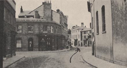
and S O along side of marker place.
Cross the level crossing at Andover Town Station.
Do not take turn to R immediately after level crossing but keep S O until faced by octagonal tollhouse, where road divides into two. Here
take L for Salisbury.
CAUTION.- 7 1/2 miles from Andover the road descends rather suddenly into a village (Wallop). At the foot of the descent is a cross road which must be taken cautiously.
This was once a famous 'police trap.'
Keep S O
2 3/4 miles from Wallop the road from Basingstoke via Stockbridge joins. This junction is called Lobcomb Corner.
7 miles from Lobcomb Corner the road descends into Salisbury.
Having entered Salisbury look out for a small inn on the L called the 'London Road House.'
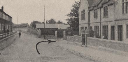
Here the road appears to go S O whereas it is necessary to
turn to the R
Then keep S O into a sort of market place with samll trees planted on L and, in front, a building with three archways.
... ...
... on arriving at Land's End there will be noticed two rival direction boards, one to 'Thomas' Temperance Hotel,' the other to 'Land's End Hotel.'
ROUTE 1. Reverse.
LAND'S END via Penzance (10), Truro (35 1/4), Launceston (81 1/2), Okehampton (100 1/4), Exeter (122 1/2), Yeovil (169 1/2), Salisbury (210 3/4), Andover (228 1/2), Basingstoke (246 1/4), and Staines (2752 1/2) to LONDON (292).
Leave Land's End by the only road, and ...
... ...
... ...
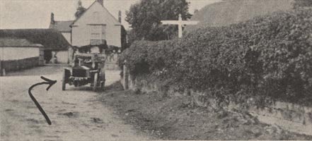
Here turn R for Wilton and Salisbury.
2 3/4 miles later, on entering Wilton, the road bears L. At cross roads in village keep S O
In leaving village, after crossing river bridge, turn R for Salisbury (3 1/4 miles).
On arriving at Salisbury from the west, pass under railway arch.
Pass clock tower and 'County Hotel' on R.
At market cross turn L
The turn R along market place and S O
7 1/2 miles after Salisbury the road divides into two at Lobcomb Corner
keep L
2 3/4 miles from Lobcomb Corner proceed cautiously down hill into Wallop,
across cross roads, and S O
On entering Andover, cross level crossing, keep along R side of market place, and on leaving it incline slightly to R but of two roads take that on L up the hill.
Whitchurch, 7 miles from Andover , will be recognised by its pretty church, round the walls of the yard of which the road winds.
At the cross roads in Whitchurch
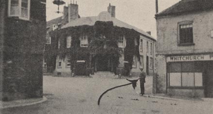
incline slightly to L past the 'White Hart Inn' (keeping the inn on the L) and S O up the hill.
On entering Basingstoke, 10 3/4 miles from Whitchurch, bear L then keep along R hand side of market place, past 'Red Lion' on L and S O up the hill.
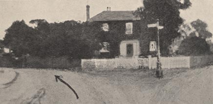
The route cannot very well be missed, except perhaps in leaving Egham (17 3/4 miles from London), where the road forks, a finger-post under a lamp standing in front of a small house, being in the middle.
... ...
turn R for Hyde Park Corner.


