county
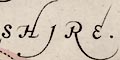
Jansson's Hampshire 1646HANTThe detached part of Hampshire in West Sussex is included, labelled:-
SHI:
RE.
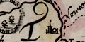
PART of HAMSHIRE.And adjacent counties are labelled, eg:-
PART OF SURREYwith or without flourishes on the lettering depending on how much space there is.:-
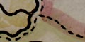
Dotted lines delimit the adjacent counties.
The county boundaries are each tinted on their county side: Hampshire yellow, Berkshire pink. Adjacent counties also have a tint: Dorset pink, Wiltshire green, Gloucestershire yellow, Oxfordshire greenBucks yellow, Surrey green, Sussex pink, Isle of Wight green. The detached part of Hampshire and the detached parts of Wiltshire are coloured to match their county. But Hayling Island and Whale Island are coloured pink? and Thorney Island green?
Four Colour Map Theorem
Cartographers and map colourists are said to have no interest in the four colour map theorem - which anyway wasn't formulated in 1646. It was a question asked by a mathematician in the mid 19th century, and is notorious because it remained unproved until the 1970s. However, just for fun, I note that it is possible to colour this uncomplicated map with three colours rather than the four used. Software MAPCOLOR.exe was used to colour the map; a colour for each county so that touching counties are coloured differently. Note that this map has detached parts which puts it outside the scope for the four colour map theorem.Hant Shire = yellow
Bark Shire = pink
Dorset Shire = pink
Wilt Shire = green
Glocester Shire = yellow
Oxford Shire = green
Buckingham Shire = yellow
Surrey = green
Sussex = pink
Isle of Wight = pink


