 |
relief, hills
Jansson's Hampshire 1646 |
|
 |
click for feature map
|
| Hills |
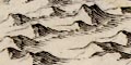
Relief on Jansson's map of Hampshire and Berkshire, 1646, is
indicated by groups of hillocks shaded to the right. The hillocks
are sometimes quite knobbly, for example in the range running
eastwards from Winchester, Magdalen Down.
Some hills are drawn realistically, others are more
conventional hillocks:-
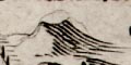
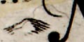
What relief is being shown is unclear; perhaps:-
- important or isolated hills
- steep scarp
- uneven ground, hilliness
- high ground, ie altitude
- watersheds
|
|
| relief |
BEWARE: to get back to this list after clicking on an item,
use the back button.
'modern' name (parish; ngr) and old name (hundred) if given |
 |
Butser Hill
(Langrish parish; SU7120)
=Butter hill(Eastmeane Hundred)
|
|
|
Danebury Hill
(Nether Wallop parish; SU3236)
=Dunbury hill(Andover Hundred)
|
|
|
Portsdown
(Portsmouth parish; SU6_0_)
|


