hundreds
Jansson's Hampshire 1646
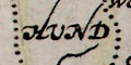
Notice that there are two Andover Hundreds. The larger is Andover Without Hundred or Andover Extra Hundred. The 'Without' part of the label is on the map attached to a hamlet symbol, an error copied from an earlier map.
The relationship between modern and old hundreds is very inexact; modern hundreds have little use today.
An interesting feature of the map can be seen in the engraving of the hundred boundaries:-
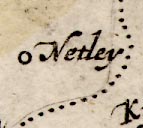
The planned line of the hundred boundary can be seen as a fine line, a soft scratch by the engraver which shows up in the final printing. The boundary engraved by dots, after placenames have been added to the map, carefully avoids the placename labels, in this instance around 'Netley'.
The hundred boundaries are not plots of a surveyed boundary, they are just lines surrounding a group of settlements which belong in the hundred, partitioning the county into administrative regions. The plotted boundary should not be treated as a line to be transferred onto another map, or GIS software, as a real boundary line.
Alton Hundred
Andover Hundred
Barmanspit Hundred
Barton Stacye Hundred
Basingstoke Hundred
Budlesgate Hundred
Buntesboro Hundred
Christchurch Hundred
Chuteley Hundred
Crundall Hundred
Eastmeane Hundred
Evinger Hundred
Fawley Hundred
Finchedeane Hundred
Fordingbridge Hundred
Hambledon Hundred
Holdshot Hundred
Horwel Hundred
Kingscler Hundred
Kingssombourne Hundred
Mansbridg Hundred
Meanestoke Hundred
Micheldover Hundred
New Forest Hundred
Odiam Hundred
Overton Hundred
Pastrae Hundred
Portes Downe Hundred
Redbridge Hundred
Rinwood Hundred
Selburn Hundred
Sutton Hundred
Thornegate Hundred
Titchfeild Hundred
Waltham Hundred


