Trees, Woods, Forests
Jansson's Hampshire 1646
Some tree symbols are more like bushses:-
woods
'modern' name (parish; ngr) and old name (hundred) if given

|
|
Trees, Woods, ForestsJansson's Hampshire 1646 |
|
|
click for feature map |
| Trees |
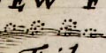
Woods and forests are shown on Jansson's map of Hampshire and
Berkshire, 1646, by groups of tree symbols, some are labelled.
The woodland areas are lightly tinted green. There are also trees
in parks. The old forests on Jansson's map are listed
below. Some tree symbols are more like bushses:- |
|
forests woods |
BEWARE: to get back to this list after clicking on an item,
use the back button. 'modern' name (parish; ngr) and old name (hundred) if given |
|
|
Arnewood(Sway parish; SZ2797) =Arnwood(Christchurch Hundred) |
|
|
Buckholt Forest =Buckholt Forrest(Thornegate Hundred) |
|
|
Chute Forest =Chure Forrest(Andover Hundred) |
|
|
East Bere Forest? =Beare Forest(Meanestoke Hundred) |
|
|
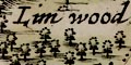
Linwood Coppice (Bramshaw parish; SU2414) =Lim wood(New Forest Hundred) |
|
|
New Forest =Newe Forest(New Forest Hundred) |
|
|
West Bere Forest =West Forrest(Kingssombourne Hundred) |
References |
Coleburn, Phil; Court, Nicky; Howe, Johnathon: 1995 (2nd edn):
Ancient Woodland: Hampshire County Council (Planning Dept)::
ISBN 01 85975 046 X |
 |
Jansson's Hampshire 1646, contents | |
|
|
feature list | |
|
|
General index | |
 |
Old Hampshire Mapped | |