latitude and longitude
Morden's Hampshire 1695
and
longitude

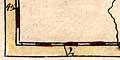
Morden's map of Hampshire, 1695, has latitude and longitude scales printed in the borders.
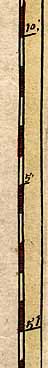
The latitude scales on left and right are chequered in 1 minute intervals, and labelled at 5 minute intervals. The longitude scale at the bottom is chequered at 1 minute intervals and labelled at 10 minute intervals. The longitude scale at the top is a scale of the time difference from the prime meridian in London. Note:-
24 hours corresponds to 360 degrees.All the scales are clearly very slanted.
II minutes [time] is 0 degrees 30 minutes West of London,
III minutes is 0d 45m W,
IIII minutes is 1d 00m W, and so on.
Calculations from the positions of the scale marks show that the ratio of latitude to longitude scales is about 1.47. It should be about 1.58 at the latitude of Hampshire; the map is stretched East_West by about 7 percent.
The angle of the 1 degree W meridian is about 14.1 degrees to vertical.
The angle of the 51 degree N parallel is a little less, about 11.2 degrees to horizontal. The lat long 'cells' are not quite rectangular; their internal angles are 93 and 87 degrees instead of 90 degrees. The discrepancy is hardly outwith the errors of the calculations, but the cells may be parallelograms, sheared rectangles.
Summary
Rectangular latitude and longitude scales, but perhaps sheared by 3 degrees W of N.
The 1 degree meridian is aligned 14 degrees west of north.
The map's horizontal scale is stretched 7 percent.
BUT, Morden probably did not plot places with the lat and long scales. It is more likely that he added the scales to an existing map that he copied. The scales might be a good fit to the existing plot.
Measured Values
Measurements in pixels from an image at 150dpi.

Corners                  A = (68,2749)
                         B = (57,58)
                         C = (3184,75)
                         D = (3183,2751)

Longitude, top           2d 00m = 210
                         1d 00m = 2616
                         0d 50m = 3018

Longitude, bottom        VII (1d 45m) = 118
                         IIII (1d 00m) = 1930
                         II (0d 30m) = 3136

Latitude, left           50d 45m = 2639
                         51d 00m = 1763
                         51d 25m = 307

Latitude, right          50d 35m = 2621
                         51d 00m = 1163
                         51d 15m = 289
Calculated Values
1 degree longitude, top = 2407
1 degree longitude, bottom = 2414

1 degree longitude = 2410
adjusted for 11.2 degree rotation = 2457

1 degree latitude, left = 3498
1 degree latitude, right = 3498

1 degree latitude = 3498
adjusted for 14.1 degree rotation = 3607

ratio lat/long (adjusted for rotation) = 1.47

compared to correct ration: 1.58 / 1.47 = 1.07
     stretch E-W 7 percent

angle of 1 degree meridian = 14.1 degree W of N

angle of 51 degree parallel = 11.2 degrees N of E

internal angles of cell = 92.9 and 87.1 degrees


