relief, hills
Norden's Hampshire 1595
- important or isolated hills
- steep scarp
- uneven ground, hilliness
- high ground, ie altitude
- watersheds
'modern' name (parish; ngr) and old name (hundred) if given

|
|
relief, hillsNorden's Hampshire 1595 |
|
|
click for feature map |
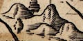
| Hills | John Norden uses little hillocks generally shaded on the east, to indicate relief. Perhaps:-
|
| hills |
BEWARE: to get back to this list after clicking on an item,
use the back button. 'modern' name (parish; ngr) and old name (hundred) if given |
|
|
Butser Hill (Langrish parish; SU7120) = butser hill (East meane Hundred) |
|
|
butser hill (East meane Hundred) = Butser Hill (Langrish parish; SU7120) |
|
|
Danebury Hill (Nether Wallop parish; SU3236) = dunbury hill (Andover extra Hundred) |
|
|
dunbury hill (Andover extra Hundred) = Danebury Hill (Nether Wallop parish; SU3236) |
|
|
Portsdown (Portsmouth parish; SU6_0_) |
  |
Norden's Hampshire 1595, contents |
|
|
feature list |
|
|
General index |
 |
Old Hampshire Mapped |