
Index sheet
Ogilby's
Hampshire
1675
Hampshire
1675
|
Index sheet Ogilby's Hampshire 1675 |
| |||||||||
|
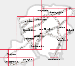
Ogilby's Hampshire 1675 | index table to map squares | |||||||||
| ... | SU56 | |||||||||
| SU55 | SU65 | SU75 | SU85 | |||||||
| SU24 | SU34 | SU44 | SU54 | SU64 | SU74 | SU84 | ||||
| SU23 | SU33 | SU43 | SU53 | SU63 | SU73 | SU83 | ||||
| SU22 | SU32 | SU42 | SU52 | SU62 | SU72 | SU82 | ||||
| SU21 | SU31 | SU41 | SU61 | SU71 | ||||||
| SU00 | SU10 | SU20 | SU60 | |||||||
| SZ09 | SZ19 | SZ29 | SZ39 | SZ69 | ||||||
| reference grid 
| To provide standardised links between these and
maps of different periods, an index grid has been overlaid on a
composite map using the Ogilby scrolls. The index grid used
is the familiar National Grid Reference system for the United
Kingdom. Ogilby's plates are strip maps of segments of road. National grid 10Km squares have been used to divide up the plates, for the purposes of comparison with other old maps of the county. The grid lines have been positioned on the strips simply by comparing the plates with modern maps. Do notice that grid lines do not run horizontally across the plates; but the plates are then divided horizontally where the grid line crosses the road and shown on screen with an added overlap. Arrows at the ends of strips take you along the road. If there are two arrows, then the road divides. Arrows at the sides take you down other routes. A line at the side switches you from one strip map of a route to an alternative. BEWARE: the 'up' arrow to a next piece goes to the top of that piece, not quite where you'd expect. You may have to scroll down to the bottom to find the continutaion of your route. |

| Ogilby's Hampshire 1675, contents |

| General index |

| Old Hampshire Mapped |