|   | Roads, Scrolls, DistancesOgilby's Hampshire 1675 | 
| 
 | 
|   | click for feature map of combined plates 
 | 
| Roads | Roads are the key feature of these maps. They are shown by a 
double line, solid or dotted.  Junctions are marked clearly, 
sometimes labelled. 
 | 
|   
 
   | Ogilby:- 
2. The Road itself is express'd by double Black Lines if 
included by Hedges, or Prick'd Lines if open; but if the 
Road be describ'd altogether by Black Lines or Prick'd Lines 
throughout the whole Plate, then the Distinction aforesaid 
of Enclos'd and Open is omitted.
 | 
|   | Ogilby sometimes gives an alternative route, eg plate 51 mile 39.  
A longer pair of routes is given at Bluck on the Heath, plate 
51, Southampton to Salisbury, miles 9-11. | 
|   | Ogilby:- 
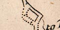
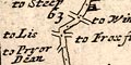
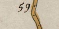
4. The several Deviations or Turnings out of the Road to 
adjacent Places on either Hand, are exprest by a short double 
Line, and are generally inscrib'd, to such a Place, 
and sometimes the reputed Distance of the said Place in Miles 
is likelwise signify'd by Figures affixt.
 
 | 
| Scrolls 
   
 
 |  
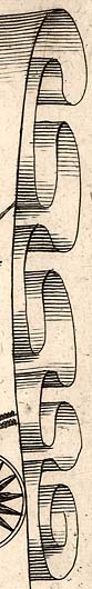
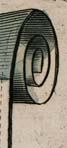
 Each route is a long narrow map of a road.  The route is arranged 
so that the user travels 'up the page' and is sectioned into 
strips, each drawn on a 'scroll' which has its ends curled 
decoratively.  The engraver has shaded the scroll to make it look 
real - which sometimes obscures map detail a little.
 
 There might be 4, 5, 6 or 7 scrolls on a plate.  Wider scrolls are 
used when the bendiness of the road demands more space.  On some 
plates the continuation from scroll to scroll is demonstrated by 
letters, a D at the top of one scroll belonging to the D at the 
bottom of the next; this device might continue onto the next plate. 
(Note that it is clearly not right to refer to scroll D, etc.) Where 
we have needed to distinguish one scroll from another, in indexing, 
scrolls have been numbered 1, 2, ... from the left of each plate.
 
In the Delineation or Decyphering these Roads upon 
Copper-Sculptures:1. We have Projected them upon imaginary Scrolls, the Initial 
City or Town being always at the Bottom of the outmost Scroll 
on the Left Hand; whence your Road ascends to the Top of the 
said Scroll; then from the Bottom of the next Scroll ascends 
again, thus constantly ascending till it terminate at the Top 
of the outmost Scroll on the Right Hand, as by the Succession 
of Figures representing the Miles, mostly plainly appears.
 
 | 
| Distances | Distances are give beside the road, miles measured from London; 
or from the lesser starting point of a cross road. | 
|   | Ogilby:- 
... the beginning of Computation from the Standard in Cornhill 
... the said Miles being exprest by double Points, and numbred 
by the Figures 1, 2, 3, &c. Each subdivided into  8 Furlongs, 
represented by the single Points included between the said 
double Ones.
The measurements seem to be very accurate; but things occasionally 
slip.  The double and single points might be muddled or misplaced; 
the numbering wrongly engraved; etc.  In the version of plate 53 in 
the HMCMS collection the distances on the map disagree with 
the distances quoted in the text source.  The version of plate 97 
has erasures and corrections. 
 It is possible to match Ogilby's roads to today's with 
surprising accuracy - where the road still exists.
 | 
| Side turnings
 | Ogilby's maps occasionally label turnings with a distance as well 
as a place to which the turning leads; in Hampshire:- 
 pl.30 scroll 4 mile 44'5 1:m: to Hasilmore
 
 pl.30 scroll 5 mile 55'2, Petersfield to Chichester: 10m
 
 pl.32 scroll 1 mile 69'6, Monxton to Winchester 12.m.
 
 pl.51 scroll 6 mile 8'3, Romsey to Andover 12 mile
 
 pl.81 scroll 3 mile 31'3 to Reding 12m.
 
 pl.81 scroll 3 mile 33'6, Kingsclere to Reding 10m.
 
 pl.81 scroll 3 mile 33'4, Kingsclere to Andover 14m
 
 pl.81 scroll 4 mile 39'2 to Reding 10.m.
 
 pl.81 scroll 4 mile 41'5 to Reding 10.m.
 
 When compared to modern distances these all appear to be 
customary miles, not the statute miles that Ogilby uses for his 
survey.  Ogilby himself remarks in his introduction that he 
gives:-
 
... sometimes the reputed Distance of the said Place in Miles ...
 | 
| Computed miles
 | In the Itinerary associated with the maps there are lists of 
both 'computed' and 'measured' distances from London.  Computed 
is the 'vulgar computation' which Ogilby includes so the reader:- 
... may easily observe the Erroneous and Irregular Consequences
following dependence on these reputed, old, distances.  His 
measured distances are much better. 
 Assuming that the computed distances are road distances we 
might calculate an estimate of the customary mile.  But, the 
assumptions in doing this are cosiderable; is it the same route, is 
the vulgar computation a centre to centre distance, etc, - which 
Ogilby comments upon.
 
 | 
| Route planner
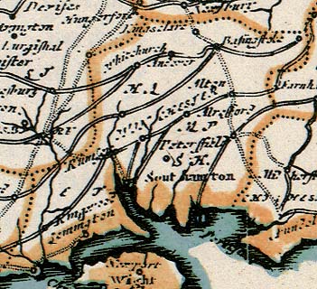
 |  Ogilby provides a map of the whole of England and Wales, shewing 
all the roads, at the beginning of his atlas.  This is the part 
for Hampshire.
 | 
| comparison roads
 
   | STRIP MAPS RELATED TO OGILBY'SAlthough the correspondences are not always exact the 
following tabulation indicates what strip maps by later map makers 
show the same 'journey' even if not the same road as 
Ogilby's.
 A question mark indicates that a plate is believed to exist but 
its number is not known.
 
 These lists do not include references to text itineraries, which 
are used by some later authors, Paterson for instance, instead 
of plates.
 
 | 
|  | Ogilby plate 25 | Moll 1718 ? | 
|  |  | Senex 1719 (1757) pl.25 (pl.25) | 
|  |  | Gardener 1719 pl.25 | 
|  |  | Bowen 1720 pl.60 and 61 | 
|  |  | Gents Mag supplement 1765 | 
|  |  | Kitchin 1767 pl.25 | 
|  |  | Jefferys 1775 pl.25 | 
|  |  | Bowles 1782 pp.45/46 | 
|  |  | Paterson 1785 pp.43/44 and 45/46 | 
|  |  | Baker 1802 opp p.51 | 
|  |  | Mogg 1814 pp.73/74, 75/76, 99/100, and 101/102 | 
|  | Ogilby plate 26 | Moll 1718 ? | 
|  |  | Senex 1719 (1757) pl.26 (pl.26) | 
|  |  | Gardener 1719 pl.25 | 
|  |  | Bowen 1720 p.62 | 
|  |  | Gents Mag supplement 1765 | 
|  |  | Kitchin 1767 pl.25 | 
|  |  | Jefferys 1775 pl.26 | 
|  |  | Bowles 1782 pp.45/46 | 
|  |  | Paterson 1785 pp.47/48 | 
|  |  | Baker 1802 opp p.52 | 
|  |  | Mogg 1814 pp.101/102 | 
|  | Ogilby plate 30 | Moll 1718 ? | 
|  |  | Senex 1719 (1757) pl.30 (pl.30) | 
|  |  | Gardener 1719 pl.30 | 
|  |  | Bowen 1720 p.73 (B073) | 
|  |  | Gents Mag July 1765 | 
|  |  | Kitchin 1767 pl.30 | 
|  |  | Jefferys 1775 pl.30 | 
|  |  | Bowles 1782 pp.57/58 | 
|  |  | Paterson 1785 pp.31/32 and 33/34 | 
|  |  | Mogg 1814 pp.29/30 and 31/32 | 
|  | Ogilby plate 32 | Moll 1718 ? | 
|  |  | Senex 1719 (1757) pl.32 (pl.32) | 
|  |  | Gardener 1719 pl.32 | 
|  |  | Bowen 1720 p.78 | 
|  |  | Gents Mag July 1775 | 
|  |  | Kitchin 1767 pl.33 | 
|  |  | Jefferys 1775 pl.32 | 
|  |  | Bowles 1782 pp.61/62 | 
|  |  | Paterson 1785 pp.69/70 and 71/72 | 
|  |  | Mogg 1814 pp.159/160 | 
|  | Ogilby plate 39 | Moll 1718 ? | 
|  |  | Senex 1719 (1757) pl.39 (pl.40) | 
|  |  | Gardener 1719 pl.39 | 
|  |  | Bowen 1720 p.97 | 
|  |  | Gents Mag July 1765 | 
|  |  | Kitchin 1767 pl.41 | 
|  |  | Jefferys 1775 pl.40 | 
|  |  | Bowles 1782 pp.77/78 | 
|  | Ogilby plate 51 | Moll 1718 ? | 
|  |  | Senex 1719 (1757) pl.51 (pl.54) | 
|  |  | Gardener 1719 pl.51 | 
|  |  | Bowen 1720 p.129 and 130 | 
|  |  | Gents Mag July 1765 | 
|  |  | Hinton 1765 pl.20 | 
|  |  | Kitchin 1767 pl.55 | 
|  |  | Jefferys 1775 pl.54 | 
|  |  | Bowles 1782 pp.103/104 | 
|  |  | Paterson 1785 pp.37/38, 39/40, and 43/44 | 
|  |  | Mogg 1814 pp.81/82 and 83/84 | 
|  | Ogilby plate 53 | Moll 1718 ? | 
|  |  | Senex 1719 (1757) pl.53 (pl.57) | 
|  |  | Gardener 1719 pl.53 | 
|  |  | Bowen 1720 p.135 | 
|  |  | Hinton 1765 pl.21 | 
|  |  | Kitchin 1767 pl.58 | 
|  |  | Jefferys 1775 pl.57 | 
|  |  | Bowles 1782 pp.109/110 | 
|  |  | Paterson 1785 pp.59/60 and 61/62 | 
|  |  | Baker 1802 opp p.51 | 
|  |  | Mogg 1814 pp.131/132 and 133/134 | 
|  | Ogilby plate 81 | Moll 1718 ? | 
|  |  | Senex 1719 (1757) pl.81 (pl.89) | 
|  |  | Gardener 1719 pl.81 | 
|  |  | Bowen 1720 p.216 and 217 | 
|  |  | Kitchin 1767 pl.91 | 
|  |  | Jefferys 1775 pl.89 | 
|  |  | Bowles 1782 pp.167/168 | 
|  | Ogilby plate 83 | Moll 1718 ? | 
|  |  | Senex 1719 (1757) pl.83 (pl.91) | 
|  |  | Gardener 1719 pl.83 | 
|  |  | Bowen 1720 p.223 | 
|  |  | Kitchin 1767 pl.93 | 
|  |  | Jefferys 1775 pl.91 | 
|  |  | Bowles 1782 pp.171/172 | 
|  | Ogilby plate 97 | Moll 1718 ? | 
|  |  | Senex 1719 (1757) pl.97 (pl.52) | 
|  |  | Gardener 1719 pl.97 | 
|  |  | Bowen 1720 p.263 and 264 | 
|  |  | Gents Mag July 1765 | 
|  |  | Hinton 1765 pl.20 | 
|  |  | Kitchin 1767 pl.50 | 
|  |  | Jefferys 1775 pl.52 | 
|  |  | Bowles 1782 pp.93/94 | 
|  |  | Paterson 1785 pp.39/40, 41/42, and 43/44 | 
|  |  | Mogg 1814 pp.83/84, 85/86, 87/88, 89/90, 77/78, and 79/80 | 
|   | Road diagrams from maps of 1675 onwards. | 
|   | Ogilby's influence on later maps and itineraries. |