
Old Hampshire Mapped

Route Analysis
Ogilby's Hampshire 1675
index map
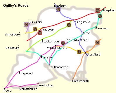
These maps were the source for many imitations. They were used by later map makers, who included all or most of Ogilby's set of routes in strip maps and on county maps of Hampshire for the next hundred years. The routes are important in their own right and as a 17th century map of parts of Hampshire.
Ordnance Survey: 1998: North Hampshire: George Philip:: ISBN 0 540 07472 1
Ordnance Survey: 1998: South Hampshire: George Philip:: ISBN 0 540 07477 1
sources
and
conventions
'Left' and 'right' in our notes assume the traveller is going up the page, the mile numbers increasing. The start of a road on a sheet is the bottom of the leftmost scroll.
The distances given are based on the position of the maps' mile numbers, even when they do not match the double spots which are intended to mark the miles. This makes it easier to match features at a glance; the figures usually agree with the descriptive text. The nearest furlong below is specified as a guide and ordering device; the furlong cannot be precise where the miles are inaccurately placed and where spots are missing from the strip map. Whatever system is used there will be some inconsistencies, including some miles which are too long. At scroll ends there may be problems with legibility, sometimes a small overlap or gap between scrolls and a few distances copied innaccurately between routes.
Compass bearings are given only to false point accuracy. John Ogilby's preface shows that he was aware of magnetic deviation, which was about 3 degrees west in 1675.
Modern road names and numbers are given approximately every mile, unless they change more frequently. Brackets around a road number implies that it was formerly used; in many instances main roads have been diverted as recently as the last few decades of the 20th century. It is worth saying that Ministry of Transport road numbers are not stable in the long term and should not be used by researchers as 'fixed' or 'safe' references to routes.
precision
Various degrees of accuracy are used: for example, a village off the road marked on Ogilby's map by its church will be assigned the 8 figure ngr of the church if it can be identified; on the other hand an area of heath may cover several 4 figure ngr squares.
8 figure grid references for features on the road itself are shown in bold type, and these can be used to help plot Ogilby's route on a modern map of Hampshire, but it must be understood that they are a guide only, and that the degree of precision implied is false. For a settlement or a mile number the ngr given is a best guess. The coordinates given for a cross roads mark where the turnings now meet the present road. Except where buildings lined the route, it is important to realise that roads were less well defined in the 17th century when less land was enclosed, and before the introduction of all weather road surfaces. John Ogilby on horseback may have recorded the exact path he took within those roads; the lines he draws look surprisingly uniform in comparison with the wandering roads of variable width that appear on Taylor 1759.
a match?
The introduction of turnpikes does not seem to have had a great effect on Ogilby's routes in Hampshire. Road realignment and major road building during the 20th century has had an impact, though signs of previous routes are often still visible, sometimes appearing more clearly on the OS 1:25000 map than on the ground. The most difficult parts of roads to trace are where there are now suburbs, or where routes went across unenclosed downland and heath.
There are sometimes inconsistencies in numbering between a scroll and the accompanying text, not match. This is particularly noticeable in Basingstoke, plates 25, 53 and 81, and Petersfield, plates 30, 39 and 81.
Raw data for plotting can be downloaded for each plate.
Our interpretation of Ogilby's route on a coloured relief background is included in the topic on road books.

