


Ogilby 1675 plate 25 scroll 6
London to Land's End
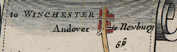
...you come at 66 M. to Andover, an indifferent large Borough-Town extending 3 F. on the Road, and about as much transverse. 'Tis seated on a Branch of the Test, affords good Accomodation to Travellers: and elects Parl-Men; having a great Mt. on Saturd. well stor'd with all sorts of Provisions, &c. also 2 Fairs, viz. on May 1st. and November 6th.

mile ' furlong
66'5 end of scroll SU36284530
continues on plate 26, scroll 1; route to Barnstable on plate 32, scroll 1 starts here; (on both routes about 5 furlongs overlap).
66'4 road SU36384535
Bridge Street (A303); crosses the River Anton, not shown on this map.
66'3 cross roads SU36504535
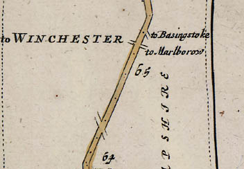
Left to WINCHESTER is Winchester Road (A3057);
Right is High Street (A343); wide main street.
66'3 town SU36504535
Andover;
66'2 turning right SU36674535
to Newbury is East Street (A343);
66'2 road SU36674535
London Street (A303);
66'1 turning left SU36874537
is Micheldever Road (A303);
66'0 mile number SU37124558
65'6 bend left SU37324570
65'4 road SU37694578
London Road (B3400); residential road.
65'4 turning right
to Basingstoke; this would have joined the Harrow Way (Taylor 1759).
65'3 road SU38154587
the route continues directly ahead, changing from B3400 to an unclassified road.
65'3 cross roads SU38154587
Icknield Way; new junction with roundabout now.
Left to WINCHESTER is Picket Twenty;
Right to Marlborow (Marlborough) is Churchill Way A3093;
65'0 mile number SU38814600
64'4 road SU39324610
London Road B3400;
64'3 cross roads
Left; no turning now at this angle.
Right; no turning now.
64'0 bend right SU40324626
less bend now.
64'0 mile number SU40324626
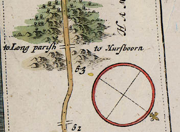
Then over another Vale somewhat Woody...
63'6 wood SU4046
Harewood Forest; partially wooded now.
63'4 road SU40894650
B3400; this was unenclosed land (Milne 1791); the route taken may not match the present B3400 exactly.
63'4 hilly land SU4046
Andover Down;
63'2 cross roads SU41414654
Test Way;
Left to Long parish (Longparish); a track.
Right to Hursboorn (Hurstbourne Tarrant); a track.
63'0 mile number SU41834653
62'5 bend left SU42384655
the road bends here now crossing an old railway line.
62'4 compass
shows UP is SW from 54'4 to 66'5; actual UP is WSW from 54'4 to 64'0.
62'4 road SU42634644
B3400;
62'3 bend right SU42744638
rejoin B3400.
62'2 road SU42964638
Ogilby's route does not match the present B3400 exactly; this was unenclosed land (Milne 1791)
62'1 cross roads SU43164638
Faulkner's Cross; leave B3400 and travel due east.
Left; a track.
Right; a track.
62'0 mile number SU43264640
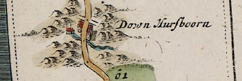
...cross a Valley at 61'5 and pass thro' Husboorn-V.
61'6 cross roads SU43744643
Left is Longparish Road B3084;
Right is B3084; the turning is now offset to SU43784642.
61'5 village SU43904640
Down Hursboorn (Hurstbourne Priors); the village is now on the B3084, no houses near the river.
61'4 house left
61'4 hilly land SU4446
61'4 river SU44074635
Bourne Rivulet;
61'4 road SU44074635
B3400;
61'2 bend right SU44334641
61'0 mile number SU44574691
61'0 bend left SU44574691
slight bend now.
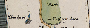
...and a Park on the Right, for a Mile together,
Hence by Charlcot-Ch. on the Left,...
...avoid these following Turnings. At ... 60'0 The Right to St. Maryborne.
60'4 park right SU4447
Hurstbourne Park;
60'4 road SU45184735
B3400;
60'3 village left SU45754683
Charlecot (Tufton); this is Tufton church.
60'2 bend right SU45554740
60'0 turning right SU45654764
to St.Mary-born (St Mary Bourne); the park drive, now not a through route.
60'0 bend left SU45694771
now the site of the A34 bypass.
60'0 mile number SU45694771
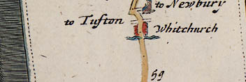
...pass at 59'4 to Whitchurch of near 4 F. on Test flu. an ancient Mt. and Borough-Town, Govern'd by a Mayor, and choosing Burgesses for Parl. 'Tis now much decay'd, yet has 2 Fairs, viz. on October 23. and Whitson-Munday.
59'6 turning right SU45904774
to Newbury is Wells's Lane; beside (dismantled) railway.
59'6 church right SU45984778
Whitchurch;
59'6 bend right SU46014773
59'6 road SU46054790
Church Street B3400;
59'5 bend left SU46264806
59'5 cross roads SU46264806
Left to Tufton is Winchester Street (A34);
Right is Newbury Street (A34);
59'4 town SU46354813
Whitchurch; Ogilby's map shows few houses and the name in italic script, implying a village. In his text it is noted as a market town.
59'3 river
the mill lade runs close to the road but does not cross it.
59'3 road SU46544822
London Street B3400;
59'0 road SU47184821
London Road B3400;
59'0 mile number SU47184821
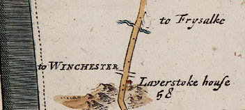
...and Laverstoke-House on the same [right] hand at 58'1 and on a small Asc.
58'7 turning right SU47384824
to Frysalke (Freefolk Priors) is London Road B3400; rejoin this, which is the main road now (see Taylor 1759).
58'6 turning right SU47614818
to Frysalke (Freefolk Priors); a track (see Taylor 1759).
58'5 river SU47854818
River Test;
58'4 road SU48004823
the route south of the river, now a track, is likely to be the approximate route (see Taylor 1759).
58'1 cross roads SU48724846
Left to WINCHESTER; a track
Right; track to river crossing
58'0 house right SU48754858?
Laverstoke House; the present Laverstoke House is on a hill but across the river; perhaps this was Freefolk Manor? (see Taylor 1759).
58'0 mile number SU48854852?
position uncertain, the distances and features don't match well.
58'0 road SU48854852?
probably a track south of the Test (see Taylor 1759).
57'7 hilly land SU4848
57'7 bend right
exact route unclear.
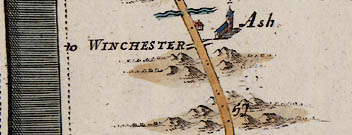
Whence by Ash-Ch. on the Right
57'6 road
leave the main road about here for a route south of the river.
57'6 river
no river crossing for the road now, unless going through Laverstoke Park.
57'5 building right SU492486
Laverstoke Mill?;
57'4 road SU49534866
London Road B3400;
57'3 village right SU49724904
Ash (St.Mary's Church, Laverstoke); the ruins of St.Mary's Church are here; Ashe is near 54'7.
57'3 cross roads SU49704870
Left to WINCHESTER; a track.
Right; a footbridge over river, towards chapel (see Greenwood 1826).
57'3 hilly land SU4948
Wool Down;
57'0 mile number SU50154904
route unsure, the distances and features don't match well.
57'0 hilly land SU5049
Rotten Hill;
57'0 road SU50154904
Rotten Hill B3400;
...come at 56'4 to Setherton-V.
56'6 turning left SU50484933
now a track.
56'5 cross roads SU50714948
Left is Vinns Lane; now a track.
Right is Southington Lane;
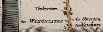
56'4 village SU50904952
Tetherton (Southington);
56'4 cross roads SU50994955
Left is Dellands Lane;
Right; now a path to a footbridge over river Test.
56'3 road SU51154963
High Street B3400;
56'2 cross roads SU51384968
Left to WINCHESTER is Red Lion Lane; joins Winchester Street.
Right to Overton is Bridge Street; Overton was centred north of the river Test.
56'1 cross roads SU51534969
Left to WINCHESTER is Winchester Street;
Right to Newbury is Kingsclere Road B3051;
56'1 road SU51534969
London Road B3400;
56'0 mile number SU51814965
Backwards Turnings to be avoided...4 F. beyond Setherton the Left to Reding.
Backwards Turnings to be avoided...1'4 beyond Setherton the Right and Left acute.
55'7 bend right
road straight now.
55'7 turning right
to Reding (Reading); no turning now at this angle, but river crossings at Quidhampton and Polhampton.
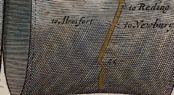
55'5 cross roads SU52454962
Left to Alresfort (New Alresford) is Berrydown Lane; leads to Waltham Lane, then Popham Lane.
Right to Newbury; minor road joining A339.
55'4 road SU52644953
B3400;
55'0 mile number SU53154958
55'0 bend right SU53464960
no bend now, road realigned (see Taylor 1759).
55'0 turning left SU53464960
is Burley Lane; a turning is indicated here in Ogilby's text and is just distinguishable on the strip map (also see Taylor 1759).
54'7 bend left SU53454970
54'7 turning right SU53454970
minor road through Ashe.
54'4 end of scroll SU54044978
continues on plate 25, scroll 5 (about 2 furlongs overlap) towards London.


