
Ogilby 1675 plate 97 scroll 1
London to Poole

mile ' furlong
73'4 end of scroll SU42002387
continued on plate 97 scroll 2 towards Poole.
73'4 house right SU424253
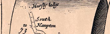
Hursly lodge (Hursley Park); house not drawn here: see start of scroll 2.
73'0 mile number SU42772443
73'0 turning left SU42772443
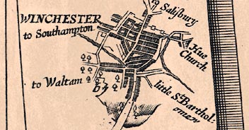
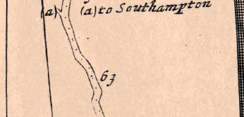
to South Hampton is Hursley Road B3043; road to Southampton now. See Ogilby plate 97 scroll 7 mile 6'0.
72'7 bend right SU42822461
A3090 (A31);
72'7 road SU42822461
A3090 (A31);
72'6 bend left
... at 72'4 Hursley-V.
72'4 bend left
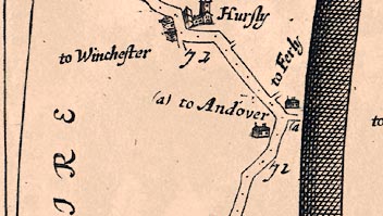
72'3 church right SU42782527
Hursley church;
72'3 village SU42862529
Hursly (Hursley);
72'3 bend right SU42862529
72'3 turning left SU42862529
to Winchester is Port Lane; minor road to Winchester.
72'1 bend left SU42622578
72'0 mile number SU42652601
72'0 turning right SU42652601?
right of way; or track at SU42632593.
71'6 road SU42672630
A3090 (A31);
71'4 turning right SU42772672
to Ferly (Farley Farm SU396277); see also Taylor 1759. Minor roads, passing Merdon Castle, lead to Farley Farm and its nearby church.
71'3 settlement SU42812681
Standon;
71'3 bend left SU42832685
71'3 road SU42832685
A3090 (A31); Merdon turnpike marked here on Milne 1791.
71'3 turning right SU42842687
to Andover is Farley Mount Road; minor roads to Kings Somborne, then A3057 to Andover.
71'2 house left
no building here.
71'1 road SU43212708
A3090 (A31);
71'1 bend left SU43212708
slight bend now.
71'0 mile number SU43372712
note only 7 furlongs between miles 70 and 71.
70'6 bend right SU43632716
... at 69'4 pass thro' Pit-V.
70'3 bend right SU44082734
slight curve now.
70'0 mile number SU44632766
70'0 road SU44632766
A3090 (A31);
69'5 turning right
to Andover; see Taylor 1759 for a turning here, joining Enmill Lane.
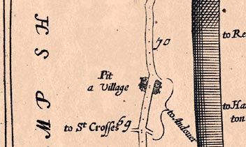
69'4 village SU45162802
Pit a Village (Pitt);
69'2 road SU45582827
(Romsey Road) (A3090, A31); on old road alignment at roundabout.
69'0 mile number SU45982862
69'0 cross roads SU45982862
Right to Andover is Kilham Lane; minor roads to Kings Somborne, then A3057 to Andover.
Left to St Crosses is Stanmore Lane; directly to St. Cross. See Ogilby plate 97 scroll 7 mile 11'2.

Leaving Winchester ascend a Hill;
68'6 road SU46262890
Romsey Road B3040 (A3090, A31);
68'3 bends SU46702933
the road bends left here as it leaves the line of the roman road to Salisbury.
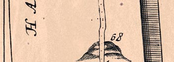
68'0 hill up SU4729
West Hill;
68'0 mile number SU47322947


Forward Turnings to be avoided... At 67'5 The Right at the End of Winchester, to Salisbury.
... leads at 67'4 to a Desc. of 2 F to WINCHESTER; an ancient and fair City adorn'd with fine Buildings, both Publick and Private:
Its Cathedral dedicated to the Holy Trinity, is a large and stately Structure, in which, several Ks. and Qs. of England were Interr'd, besides the Prebends Houses, the Bishop's Palace call'd Woolvey-House, and the Hall where the Assizes and Sessions are Held; and where K. Arthur's Round Table is kept.
In the Suburbs is Winchester-College well-endow'd; and govern'd by a Warden, Master and Usher:
The Bishops of Winchester are Chancellors to the See of Canterbury, and successively Prelates of the Noble Order of the Garter.
This Bishoprick is reputed the best in the Kingdom; the Diocess containing the Counties of Hamsh. and Surrey with the Islands of Wight, Jarsey and Garnsey.
67'6 road SU47672957
Castle Avenue B3040 (A31); passes over railway.
67'5 turning right SU47792961
to Salisbury is Upper High Street B3049 (A272); to Salisbury via Stockbridge.
67'5 turning right SU47792961
is Sussex Street B3420; roman road.
67'.. road SU47882957
High Street B3040; (West Gate - Milne 1791.)
67'.. town wall SU47882957
wall to right, wider area to left (see Speed 1611, Milne 1791).
67'.. church right
Hue Church (Hyde Church - St. Bartholomew's); the feature is clearer on plate 39 scroll 6.
67'.. turning left SU48102949?
to Southampton is Little Minster Street?; or another way to Kings Gate: this was Ogilby's route on plate 97 scroll 7 mile 12, from Southampton.
67'.. city SU48302942
WINCHESTER; there are similar plans by Ogilby on plate 97 scroll 7, and on plate 39 scroll 6 which also has text.
67'.. turnings
see Speed 1611, Milne 1791 to identify the turnings off this road.
67'.. road SU48302942
High Street (B3040); pedestrianised street.
67'.. road SU48502932
The Broadway (B3040); (East Gate - Milne 1791). See gate on plate 39 scroll 6 and plate 97 scroll 7.
67'.. river SU48602930
River Itchen;
67'.. bend right SU48652930
probably turn to enter Winchester by East Gate (see Speed 1611, Milne 1791).
67'.. turning left SU48652930?
to Waltam (Bishops Waltham) is Chesil Street B3330; (Cheese Hill Street - Milne 1791). Minor roads to Bishops Waltham, partly using route of roman road.
67'.. road SU48652947?
Water Lane; or parallel route along St. John's Street, (see Milne 1791).
67'.. bend left SU48652957?
turn into Water Lane (see Speed 1611).
67'.. road SU48652957?
Blue Ball Hill; (Red House Lane - Milne 1791). Note that the route taken through Winchester is not indicated.
67'.. turning right SU48762955?
is Beggars Lane;
67'0 wood left SU4829
now built up.
67'0 unidentified right
little St. Bartholomew; Winnall Church, in this direction, is not dedicated to St. Bartholomew.
67'0 mile number SU48852952
66'5 wood SU4929
now Winchester suburb.
66'5 road SU49422944
Alresford Road B3404 (A31);
66'5 hill down SU4929
St. Giles Hill;

... by Magdalen-House on the Right
66'0 mile number SU50302944
66'0 road SU50302944
Alresford Road B3404 (A31);
65'6 bend right
road now straight, as shown on plate 39, scroll 6 mile 27.
65'5 house right SU50582962
Magdalen house (St. Mary Magdalen's Hospital - site);
65'5 turning right SU50862943
minor road past Winnall Down Farm. Turning was further west and at a sharper angle previously, see Milne 1791, Greenwood 1826.

... whence for the most part an open Way
65'1 cross roads SU51982941
Right is Chapel Lane;
Left is A31; roundabout here now.
65'0 mile number SU52162941
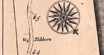
64'7 compass
UP is shown as SW from 59'7 to 74'4; it should be WSW from mile 60 to 68.
64'6 road SU52712941
Alresford Road A31; see plate 39 scroll 6 for better road orientation here.
64'3 turning left SU53302941
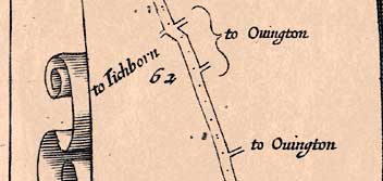
to Tichborn (Tichborne); track, right of way, then other tracks to Tichborne: this was Ogilby's route on plate 39, scroll 6, towards Petersfield and Midhurst. Note turnpike cottages here.
64'0 mile number SU53822941

Forward Turnings to be avoided ... At 63'6, The Left acute.
63'6 turning left SU54102940
to Southampton; track, right of way, to Twyford: this was Ogilby's route on plate 51, scroll4, towards Southampton.
63'6 bend right SU54222944
now a large bend.
63'4 road SU54402962
Alresford Road A31; plate 51 scroll 4 has different distances.
63'0 mile number SU55053000
62'6 bends
road straight now.
62'6 road SU55143003
(A31); track alongside realigned A31.
62'4 road SU55403024
Alresford Road A31; see plate 51 scroll 4 for different road alignment.
62'3 bend right SU55773047
62'3 cross roads SU55773047
Right to Ovington; into Ovington.
Left to Tichborn (Tichborne) is Rodfield Lane; minor road, then footpath back to Titchborn.
62'2 bend left
road now straight.
62'0 mile number SU56203092
62'0 turning right SU56203092
to Ovington; track, right of way, joins minor road to Ovington.
61'3 road SU57003162
Alresford Road A31; realigned here where road is rejoined by A31 bypass.
61'3 turning right SU57003162
to Ovington is East Lane; into Ovington.
61'2 road SU57143192
Alresford Road B3047 (A31);
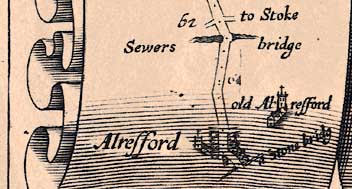
... over Sewers-Br, at 60'7
FROM London to Alresford, (as in the Southampton-R.) whence for the most part an open Way ... affording in most Parts a good Road,
and fitting Enter[t]ainment for Travellers.
61'0 cross roads SU57263204
see plate 51 scroll 3 for different turnings and destinations.
Right to Stoke (Itchen Stoke) is B3047; into Itchen Stoke.
Left; minor road into Tichborne.
61'0 mile number SU57263204
60'7 bridge SU57423222
Sewers bridge (Seward's Bridge);
60'7 river SU57423222
River Itchen;
60'7 bend left SU57453225
60'6 road SU57573229
Winchester Road B3047 (A31);
60'4 unidentified SU58003239
perhaps an erroneous mile number 6[ ].
60'4 road SU58003239
The Avenue B3047 (A31);
60'3 bend right SU58003239
no bend on plate 51 scroll 3 but a slight widening of the road here, also see Milne 1791
60'2 road SU58453258
Pound Hill B3047 (A31); from Alresford to Sewards Bridge is 1f longer on plate 51.
60'2 village right SU58823366
Old Alresford;
60'1 cross roads SU58613262
Right is The Dean; footbridge over river; then track.
Left is Jacklyns Lane B3046;
60'1 road SU58653263
West Street B3047 (A31);
60'0 town SU58823270
Alresford (New Alresford); see also plate 51 scroll 3.
60'0 church left SU58823264
New Alresford Church;
60'0 turning left SU58823270
is East Street B3047 (A31);
60'0 bend right SU58823270
T junction.
60'0 (mile number not shown) SU58823270
59'7 road SU58803285
Broad Street B3046;
59'7 river SU58803303?
River Alre; Taylor 1759 shows a mill lade here; the main outlet from the pond is further north.
59'7 bridge SU58803303?
a Stone bridg; a causeway over several channels.
59'7 road SU58803303?
Mill Hill?; or The Soak at SU58853310.
59'7 end of scroll SU58803303?
Alresford to Poole: mile numbering from London, nearly matches route 51 scroll 3.


