
Old Hampshire Mapped

Route Diagrams
Notes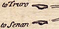
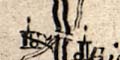
from Cowley's map of Hampshire, 1744.
Cary's map of England and Wales, 1815, uses a fringed double line:-
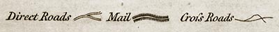
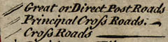
Where routes have been graded for size or importance by the mapmaker, this is shown by line thickness on the diagram.
or
route

The roads on Morden's Hampshire, 1690s, seem to have been added late in the process of engraving, after the words, and separately from the bridges.
On many maps the roads appear to have been drawn quite casually, perhaps indicating the existence of a route between towns rather than trying to show the road precisely. This is in fact the technique that has emerged as the most practical in constructing these diagrams!
Roads on smaller scale maps are usually less carefully drawn and show the road passing through fewer places. Roads included on county maps or strip maps may be missing from the corresponding general map of the country; the general map may include roads which are not on the county or strip maps.
On several small county maps, the map maker has placed settlements so inaccurately that the road's relationship to them is wrong, as in this example from Kitchin's county map of 1751:-
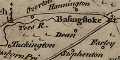
The road west from Basingstoke should go through Dean, keep well south of Hannington and just south of Overton and the river Tees. The road south-west from Basingstoke should go the other side of Stephenton.
A dotted line has been used on our route diagrams where we think the map maker has deviated significantly from his intended road, or where there is incorrect positioning of settlements relative to a road.
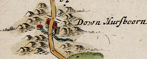
John Ogilby's strip map, plate 25, of 1675 leaves Whitchurch and skirts south of Hurstbourne Park to pass through the village of Hurstbourne Priors, where he crosses the Bourne Rivulet on the way to Andover. He calls the village Down Hursboorn; elsewhere it is recorded as Nether Hurstbourne, Down Husband, etc.
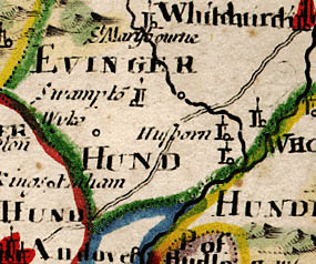
Robert Morden, in his 1690s county map, drew the road out from Whitchurch rather too straight, missing the village of Husborn.
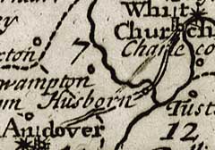
The straight road on Robert Morden's smaller map of 1701 has been amended in 1708 by Herman Moll to pass through Husborn; now two roads show where there should only be one.
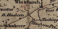
Thomas Kitchin, in 1751, shows Husborn Pri. by the Bourne Rivulet, with D. Husborn as a separate place on his straight road.
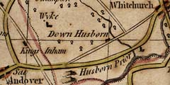
John Harrison, in 1788, shows Husborn Prior and Down Husborn as separate places, each with its own road.
- via Staines, through Hartford Bridge, Basingstoke and Andover to Salisbury, the West Country coast and Lands End.
- via Guildford and Farnham, through Alton and East Meon to Portsmouth; after 1600, via Staines, through Hartford Bridge, Alton and East Meon; in 1635-51, the mail route from Alton went via Petersfield instead of East Meon.
- via Guildford and Farnham, through Alton and Twyford to Southampton.
We can only speculate on the reasons for the absence of roads from early maps. John Ogilby, in his preface to Britannia, 1675, berates his predecessors for not surveying the roads properly. Why was this not done whilst surveying other landscape features so carefully? Why were roads not regarded as significant in comparison with other information competing for space on the map?
- Was it due to the state of the roads? Perhaps there was no concept of major and minor roads, the traveller, on foot or on horse, taking the most convenient, least muddy or rutted way between the inns or stage posts.
- Perhaps the satisfactory surveying of important roads could not be accomplished by the methods used for other features; the surveyors would be travelling by horseback, from one small settlement to the next, rather than following the major town-to-town routes.
- It could be that roads were not required by the purchasers of the maps, landowners who would be using them to put places in relationship more clearly and to understand their surroundings, rather than for travel. Perhaps for travellers who were strangers, showing roads was unnecessary because they would take it for granted that you could generally get from place to place, with some form of river crossing where required; knowledge of the precise road would be readily available locally.
- Southampton to Lymington, using Hythe Ferry.
- The route from Salisbury, via Stockbridge, to Winchester.
- The route from Winchester through Bishops Waltham to Fareham, and thence to Chichester.
- from Salisbury through Fordingbridge and Ringwood to Christchurch
- from Newbury to Andover and from Andover to Winchester
- from Oxford via Newbury and Whitchurch to Winchester
- from Reading to Odiham, Odiham to Alton, Alton to Fareham and Fareham to Gosport
Many of Ogilby's routes survive, including three important roads from London through Hampshire:-
- via Staines, through Hartford Bridge, Basingstoke and Andover to Salisbury, then a different route to Lands End.
- via Guildford, through Petersfield to Portsmouth.
- via Staines and Farnham, through Alton and now Winchester, not Twyford, to Southampton.
After the 1960's the building of motorways and bypasses has a significant effect on the roads in the county.
Box, E G: 1932-1934: Hampshire in Early Maps and Early Road-Books: ProcHCF: 12: pp.221-235
Box, E G: 1935-1937: Hampshire in Early Maps and Early Road-Books-II: ProcHCF: 13: pp.61-68
Brayshay, Mark: 1992: Royal Post-Horse Routes of Hampshire in the Reign of Elizabeth I, The: ProcHCF: 48: pp.121-134
Davies, Rev J Silvester: 1883: History of Southampton, A: Gilbert & Co. (Southampton):: pp.3, 233
James, Alan: 1970: Post, The: Batsford (London):: ISBN 0 7134 1764 1
Jervoise,E: 1930: Ancient Bridges of the South of England, The: Architectural Press (London)
MacEachren, A M & Johnson, G B: 1987 (December): Evolution, Application and Implications of Strip Format Travel Maps, The: Cartographic Journal: 24: pp.147-158
Maxwell, William H: 1899: Construction of Roads and Streets, The: St Brides Press (London)
Smith, D: 1989 (June): Strip Format Travel Maps: Cartographic Journal: 26: pp.39-41
