 Map Group CARY 1787


The map studied here is an edition of the 1787 map, published by John Cary in 1793. It is in the Map Collection of Hampshire CC Museums Service, item HMCMS:FA1998.214
(Please note that the map features and roads refer to this map, which is not illustrated.)


map maker
orientation
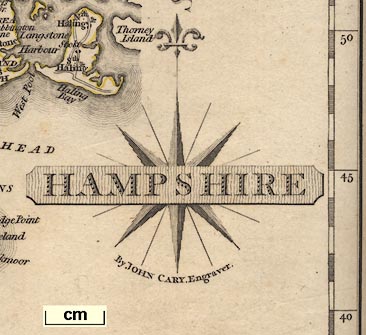
compass rose
HAMPSHIREBelow the compass rose is:-
By JOHN CARY, Engraver.Printed at the bottom is:-
London Published Jan 1st. 1793 by J. Cary, Engraver & Mapseller, StrandThe compass rose has no circle. It has star points for the cardinal and half cardinal directions, and lines for the false points. North is marked by a fleur de lys.
scale
British Statute Miles 69 1/2 to a Degree.The scale line is chequererd and labelled in miles; length 10 miles = mm, giving a map scale 1 to . The map scale is about:-
1 to
miles to 1 inch
scale
Longitude Wst. from Londonminutes of latitude = mm, gives a map scale of 1 to . The map scale is about:-
1 to
miles to 1 inchCary is the first to use longitude west from the Greenwich meridian, which was not formally established as the international prime meridian till 1884.
sea plain
ENGLISH CHANNEL
The SOLENT
Christchurch Bay
SOUTHAMPTON WATER
coast form lines
headlands
harbours
Hengistbury HeadAnd some harbours, eg:-
Portsmouth Harbour
castles
fortifications
Hurst Castle
Calshot Castle
St. Andrew's CastleThe fortifications of Portsmouth are shown, just.
ponds
bridges
Avon R.
Beauley River
Crockford Water
Auborn Riv
Bourne RiverThis Bourne is the River Bourne by South Tidworth.
TestHigher up the Test the tributary now known as the Bourne Rivulet is labelled the Anton, the Anton running into Andover is unnamed, and the head of the river is labelled:-
Source of the Hanton Riv.between Ashe and Steventon.
Ponds are drawn in outline with form lines, and perhaps labelled, eg:-
Fleet Pond
Sowley Pond
Blackmore PondThis last near Bramshott.
Bridges are suggested by the roads crossing and interupting a river. A few bridges are named, eg:-
Broken Bridge [near Brokenhurst]
Our Br.
Kitcomb Bridge [by Fullerton]A ford is labelled at:-
Jouldins Fordnorth of Eversley.
Tidbury Hill
Ports Down
forests
Holt Forest
Watmere Forest
NEW FOREST
Hackwood Park
Dogmersfield
Burley Lodge
WILT SHIREand the boundary between these counties drawn for a short way from the Hapmshire boundary by a dotted line.
A few places outside the county are drawn and labelled to make sense of Hampshire places, eg Farnham, Lopcombe Corner, Ludgershall, etc.
streets
WINCHESTERThe relationship of streets, rivers, roads, etc is visible in some detail though miniature.
SOUTHAMPTON
FAREHAMA town might have one or two starts or asterisks attached to it by a line which presumably indicate the number of members it sends to Parliament.
Froxfield
Crawley
Owslebury
house
farm
Compton
Fritham
Wyatts [a house? W of Alton]
Durham Fa. [near Maple Durham]
Lowr Farm [NW of Exton]A hamlet on a road might be marked by a small group of blocks, eg:-
Lower Froyle
Fullerton
water mills
Great Bri Mill [N of Romsey]
Mill [top of Lockerley Brook]
Overshot Watering Mill [at Lower Wallop]
Mill [at Stockbridge]I have not noticed any windmills.
docks
Dockmarking an important dockyard.
Gibbet
roman roads
roman towns
Roman Road from Old Sarum
Port Way
Roman Road [Winchester towards Silchester]
Icknield WayIt would be worth comparing these claims with what is accepted nowadays.
Silchester has its roman town marked by a ring of ?hatching with a central block.


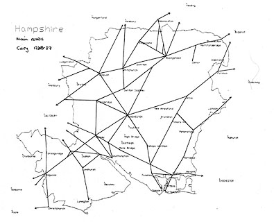
Major roads crossing the county boundary have their destination, or start, labelled, eg:-
from Salisbury
4 Miles from Amesbury
to Newbury
Miles from Hyde Park Corner London R
to London thro' Guildford
Looking closely, there are little lowercase letters labelling the major roads at the county boundary. These are grouped by county.
e
A few junctions are named, eg:-
3 Leg Cross [S of Hghclere]
Lopcombe Corner [in Wiltshire]A few roads have names, eg:
Chute Causeway
Popham Lane
Gravel Hill
Bradley Lane
New RoadThis last from near Eling towards Lyndhurst.
A label in the Lands End Road at Church Oakley:-
Dean Gatemay be a turnpike gate?

30, the Portsmouth Road, is shown.
32, from Andover towards the west, is shown.
39, the branch from Midhurst to Winchester, now shown only by minor roads.
51, the Southampton Road, but no longer the same route, Cary shows the main route through Winchester not Twyford, the older route is shown by mminor roads.
53, Basingstoke to Salisbury, is shown.
81, Oxford to Chichester, is not shown as a contnuous route though it is all shown by a mixture of major and minor roads.
83, Oxford to Salisbury, shown by only by minor roads.
97, various parts still appear as major roads, but the route from Christchurch to Lymington is now only a minor road.
Winchester, Whitchurch, Newbury.
Alton, Bishops waltham, Wickham, Fareham, Gosport.
Southampton, Wickham, Cosham, Havant, Chichester.
Salisbury, Fordingbridge, Ringwood, Christchurch.
Winchester, Stockbridge, Salisbury.
etc.
[Bagshot], Blackwater 31, Hartford Bridge 36, Basingstoke 47, Whitchurch 58, Andover 65, [Middle Wallop] 72, [Salisbury]. (Ogilby 25/26).
..., Liphook 47, Petersfield 55, Horndean 62, Cosham 68, Portsmouth [ ]. (Ogilby 30).
Andover 35, [Weyhill], Ludgershall, [Devizes].
[Bagshot], Farnham 38, Alton 48, Alresford 57, Winchester 65, Southampton [ ]. (partly Ogilby 51).
Basingstoke 46, Wheatsheaf 52 1/2, Sutton Scotney 60 1/2, Stockbridge 68, Lopcombe Corner 74 1/2, [Salisbury]. (Ogilby 53).
[Reading], Basingstoke 14 1/2.
Winchester 66, Romsey 76, Ringwood 94, [Poole].
Southampton 0, Romsey 8, [Salisbury].
These were presumably regarded as more important routes.


It was published in Cary's atlas 1787-93; and re-engraved from 1809.

Published in another edition '... London. Printed for John Cary, Engraver & Map-seller, No.181, near Norfolk Street, Strand. Published as the Act directs Jany. 1st. 1793.'
Cary, John: 1787: Cary's New and Correct English Atlas: (London)
HAMPSHIRE
IS a maritime county on the south coast of the Kingdom, which, during the Saxon heptarchy, belonged to the Kingdom of Wessex, is now included in the province of Canterbury, the diocese of Winchester, and the Western Circuit. Including the Isle of Wight, it is 55 miles long from North to South, 40 miles broad from East to West, and 220 in circumference. It contains 1540 square miles, or 985,600 acres, including also the Isle of Wight; divided into 39 hundreds, 250 parishes; one city, Winchester, which sends 2 members to parliament, and gives the title of Marquis to the Powlett family; and 20 market towns, viz. Southampton, which sends 2 members to parliament, and gives the title of Baron to the Fitzroy family; Portsmouth which sends 2 members to parliament, and gives the title of Earl to the Wallop family; Andover, which gives the title of Viscount to the family of Wallop; Christchurch, which sends 2 members to parliament; as does Stockbridge, Whitchurch, and Petersfield; with Newport, and Yarmouth, in the Isle of Wight; but the following market towns do not send representatives, viz. Basingstoke, Alresford, Alton, Fareham, Havant, Kingsclere, Odingham, Ringwood, Rumsey, and Waltham. Among the villages Titchfield gives the title of Marquis to the Bentinck family; Portchester the title of Baron to the Herbert family; and basing the title of Baron to the family of Powlett. ... This county sends 26 members to parliament, viz. 2 for the shire, and the others as expressed above; pays 14 parts of the land tax, and provides 960 men to the national militia. Its principal rivers are the Ithing or Alre, the Tees or Test, Anton, Avon, Stour, Wey, Loddon, and Auborn. It has the harbours of Spithead, Portsmouth, St Helen's, East Cowes, Hampton Water or Southampton Bay, Titchfield Bay, Langston and Hamble Haven, &c.; with a great number of points, headlands, isles, forts, castles, &c. This county has also New Forest, near 30 miles in circuit; Wulmer and 7 others; with a great number of parks, downs, &c. Its chief product is corn, cattle, pastures, wood, iron, wool, fish, and hops. It is noted for its honey, and the best bacon in the kingdom. It has manufactures of woollen; and contains extensive magazine of naval stores at Portsmouth. The air of this county is fertile and healthy, and abounds with extensive views and elegant villas; among which
The following are the most considerable
Ashley Lodge, near Fordingbridge.
Avington, near Alresford.
Bellevue, near Southampton.
Bestorn, New Forest.
Bortswood, near New Forest.
Bolderwood Lodge, New Forest.
Bramble Hill, near Fordingbridge.
Bramshill Park, near Heckfield
Burley Lodge, New Forest
Cadland Park upon the New Forest
Cannon Park, near Kingsclere
Chapman's Ford, near Winchester
Chilton Candover.
Dogmersfield, near Odiham
Dinny Lodge, New Forest
East Stretton.
Evelham
Farmborough
Freemantle Park.
Grange, near Alresford
Hackwood Park, near Basingstoke
Havant Park
Headley Park, near Alton
Heckfield Park, near Odiham
High Cliff, near Christchurch
Holmeley, New Forest
Hursley Lodge, near Winchester
Iver Lodge, near Fordingbridge
Idesworth Park.
Mallwood Lodge, near West Minsted
New Park, New Forest
Polton's, near Rumsey
Ringfield Lodge, New Forest
Rotherfield, near Alton.
Southwick Park, near Fareham
North Stoneham, near Southampton
Red Rice, near Andover
Stratfield Saye Park, near Odiham
Stubbington, near Crofton
Sydmonton, near Kingsclere
Tilney Hall, near Odiham
Walbury, near Comb
Wulverton, near Winchester
The most remarkable Views and Situations are,
Portsdown, five miles North of Portsmouth.
West Lodge, in Bere Forest.
Ashley Down.
Nunwell Down.
...
The atlas includes a map 'South Britain' 1787.


