 Map Group KITCHIN 1767


Its price was 7s6d, size 9 x 7 1/2 ins. Detail notes are only about Hampshire, and the part of Dorset that was then Hampshire.


KITCHIN'S / Post-Chaise Companion, / THROUGH / ENGLAND and WALES; / CONTAINING / All the Ancient and New Additional ROADS, / WITH / Every Topographical Detail relating thereto. / BY THOMAS KITCHIN, / For the Use of TRAVELLERS, on One Hundred and Three Copper Plates. / LONDON: / Printed for ROBERT SAYER, at No 53, in Fleet-street; JOHN BOWLES, at No , in Cornhill; and / CARINGTON BOWLES, at No 69, in St. Paul's Church-Yard. 1767. Price 7s. 6d.
table of distances
An INDEX of all the Cities, Market-Towns, and principal Villages, on the Direct Roads; shewing their respective Distance from London in measured Miles; in what County situate, and the Page in which they are to be found. These Distances are measured from the STANDARD in CORNHILL, near the ROYAL EXCHANGE.The index is formatted in four columns:-
Page / Towns. / County. / Mileswith entries on the pattern:-
55 / Alton / Hampsh. / 66 1/4There is also a:-
A TABLE of the CROSS ROADS. Shewing the measured Distances from one Town to another, and the Total Distance from the Town where the Road begins, to the Town at the End of it.The table is formatted in three columns:-
P. / Towns. / M.with entries after a heading, on the pattern:-
-- SOUTHAMPT.
55 to SALISBURY . 25 1/2
-- viz. to
-- Rumsey .............. 8 1/4
-- White Parish ....... 9
-- Whaddon ............ 3 3/4
-- Salisbury ............ 4 1/2


table of distances

The beginning of each route has a title in a plain box, the sides curved to fit within the scrolls of the route maps.

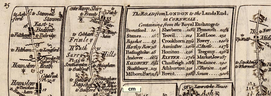
Only the first plate of a long road has a title cartouche giving the name of the road, for example plate 25 has a title, but 26 and 27 which continue the road, do not. Plate 25's title:-
The ROAD from LONDON to the Lands End, / in CORNWALL. / Containing from the Royal Exchange to / ...followed by a table of distances, in this example including:-

...
Bagshot .......... 29
Hartley Row ..... 38
Basingstoke .... 48
Andover ........... 66 1/4
Salisbury ......... 83 3/4
...
north point
up is destination

While the general bearing of the route can be taken from the north point the actual direction of a stretch of road is not so certain. The wiggles in the road are probably 'compressed' sideways to fit within the scrolls.
1 to 160000
2.5 miles to 1 inchbut remember this is just an estimate and the plates seem to be different.
coast shaded

The coast line is shaded, eg:- pl.55 m.0. At Portsmouth the sea is labelled:-
THE SEAand:-
Portsmouth Harbourand an island, pl.30 m.70, is labelled:-

Horsey I.Kitchin has drawn the west coast of Portsea Island, three of the islands in Portsmouth Harbour, and Gosport on the opposing coast. This is more than was drawn by his predecessors.
In the sea off Lands End is a ketch (?)
bridges
ferries
ponds

Avon R.and:-
Black Water
Itchin Flu.Bridges are presumably taken for granted; a road over interupts the wiggly line of the river. A bridge might be labelled, eg pl.55 m.71:-

High bridgealso:-
Portsey BriAt Southampton, by the Itchen is:-
FerryA pond is marked between Enfield and Romsey, labelled:-

a PondAlresford Pond is shown similarly, pl.55 m.59.
hillocks

Relief along the road is indicated by hillocks; it remains an open question just what is being indicated, eg:- pl.58 m.59. The hillock may be across the road suggesting a slope, up or down is not distinguished. There might be hillocks either side of the road suggesting a valley, as running into N Bavant in Wiltshire. They might suggest a ridge eg:- pl.55 m.47:-

but we think this is just the engraver running hillocks together. The hills might be spread around decoratively suggesting hilly country, eg:- pl.25 m.64:-


Woodland is suggested by little tree symbols, eg:- pl.55 m.53. A wood might be labelled, eg:-
Anstrey WoodA single tree might be labelled, eg pl.55 m.4:-

Halfway OakHalfway from Southampton to Romsey.

Parkwith a length of fence by the road before and after, on the right, just beyond Whitchurch.

County boundaries are drawn by a dotted line across the road, eg:- pl.50 m.5. This boundary is also marked by a stream. At these borders there is generally a statement like:-
enter Hamp ShireCounty names are labelled alongside each length of road, eg pl.30 m.45:-

HAMP SH.
streets
The notes below come from a quick look through the plates rather than a detailed study.

WINCHESTER

BasingstokeSouthampton has streets and gardens (burgess plots?) behind houses.

WoottonVillages off the road may be shown by a drawing of a church alone eg:- pl.41 m.27:-
labelled in lowercase italic text, eg:-

ChilcombThe church symbols are drawn 'horizontally' not correctly aligned EW; some churches have a flat top tower with a cross, others have a steeple - but I have no idea whether this is by chance or design. Two of Winchesters churches are drawn and labelled:-
H[ii]e Church
Little St. Bartholm

Enfield

Brambridge House
distances from London
distances from start

The route of the strip map is drawn by a double line; continuous or dotted. The dotted lines occur over heaths etc and probably indicate an unfenced road? The line of the road shows bends and junctions with side roads. Many turnings are labelled with a destination to a nearer or further place, eg:-
to Basing
to WinchesterA junction might be labelled, eg:-
Lobcocks CornerWhere the turning is another route in the road book this is indicated, for example on plate 33 at mile 67:-

to Salisbury Pl.25There is another example at Basingstoke where the road to Alton is labelled, to be followed on pl.91. Although the important route to Stockbridge from here, Basingstoke, is labelled, its plate number is not given.
You have to be careful following these references, the first plate of the sequence may be given, and you have to turn on to find the bit you want. There are useful hints in the footer printed beow the map, eg (on the same plate):-
Another Way from London to Salisbury is from Basingstoke to Stockbridge in Pl.58 & from thence to the Hutt in this Plate at 77m. The several Roads from Salisbury are shown in Plates 55, 84, 93 & 95.Distances from London, or from the start of a cross road, are marked along the roads at one mile intervals. A dot is drawn in the road and a figure engraved by it, eg: pl.50 m.78. Distances are also listed in introductory tables and in a table in the title cartouche, eg: pl.25:-
The ROAD from LONDON to the Lands End, in CORNWALL. Containing from the Royal Exchange to
...
Bagshot ....... 29
Hartley Row ... 38
Basingstoke ... 48
Andover ....... 66 1/4
Salisbury ..... 83 3/4
...
to Skippords Innfrom the road near Oakley. And:-
the Huttnear Lopcomb Corner.

Charlton MillThere is another at Alton.

a millThere is a 'paper mill' elsewhere.
The Race
the Stand

Fortifications are drawn to suggest polygonal style walls around Portsmouth, pl.30 m.73. At Portsey Bridge guarding Portsea Island the wall is labelled:-
a FortThere are fortifications around Gosport and around the naval base on Portsmouth Common, pl.30 m.72. Kitchin shows more fortifications in this area than his predecessors.

Free Schoolwhich is Eggars School

a post


The three tumuli of Popham Beacons are copied in an unlikely shape, pl.58 m.57, with no labelling. It feels as though the engraver had no idea what he was drawing. They are fairly indeterminate on Ogilby's map (pl.53) a hundred years earlier.
Gallows
| pl.25 | pl.30 | |
| 9.0 | 23.0 (2) | |
| 27.3 (3) | 11.0 | |
| 19.6 (2) | 12.6 | |
| 16.9 (2) | 11.8 | |
| 9.8 | 12.9 | |
| 27.7 (3) | 13.1 | |
| 18.0 (2) | 14.0 | |
| 27.5 (3) | 11.0 | |
| 9.1 | 23.5 (2) | |
| 9.1 | 22.9 (2) | |
| 18.1 (2) | 12.6 | |
| 8.9 | 11.0 | |
| 8.9 | 24.1 (2) | |
| 9.1 | 13.0 | |
| 18.1 (2) | 11.6 | |
| 26 miles | 19 miles | |
| 237.1mm | 228.1mm |
1 to 160000
2.5 miles to 1 inch


| Kitchin | Ogilby | |
| 25 | 25 & 26 | London to Lands End |
| (Basingstoke-Andover etc) | ||
| 30 | 30 | London to Portsmouth |
| 33 | 32 | London to Barnstable |
| (Andover westwards) | ||
| 41 | 39 | London to Chichester, |
| branch Midhusrt to Winchester | ||
| 50 | 97 | London to Poole |
| (Alresford-Christchurch etc) | ||
| 55 | 51 | London to Southampton |
| 58 | 53 | London to Weymouth |
| (Basinsgtoke-Stockbridge etc) | ||
| 91 | 81 | Oxford to Chichester |
| (Kingsclere-Petersfield etc) | ||
| 93 | 83 | Oxford to Salisbury |
| (Shipton Bellinger etc) |
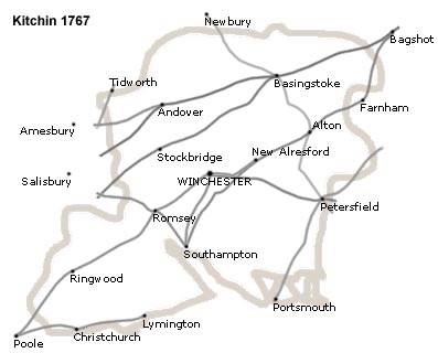
Much simplified the roads plotted by Kitchen in Hampshire are:-


A General MAP of the / Direct & Principal Cross / ROADS, / in ENGLAND and WALES; / extended to Edinburgh in / SCOTLAND.
Direct Roads are described thus //
Cross Roads thus /
The figures on the Roads in this Map refer to the Pages where they may be found.When using this index map do note that the page reference is to the start of the route, you may have to turn a page or two to find your place.
compass rose
1 to 3500000
55 miles to 1 inch
sea plain
ENGLISH CHANNEL
BRITISH OCEAN
coast shaded
Some headlands and bays are labelled; none of relevance to Hampshire.
The coasts of Ireland and France are drawn in outline with a few towns.


Published in 'KITCHIN's Post-Chaise Companion, THROUGH ENGLAND and WALES; CONTAINING All the Ancient and New Additional ROADS, WITH Every Topographical Detail relating thereto. By THOMAS KITCHIN, For the Use of TRAVELLERS, on One Hundred and Three Copper Plates. London: Printed for ROBERT SAYER, at No 53, in Fleet-street; JOHN BOWLES, at No , in Cornhill; CARRINGTON BOWLES, at No 69, in St. Paul's Church-Yard; 1767. ...'
Published in 'Kitchin's Post-Chaise Companion ... London: Printed for and sold by Carington Bowles, at his Map and Print Warehouse, No.69, in St. Paul's Church-Yard,' 1770.
Published in 'Nouvel Atlas D'Angleterre Divise En ses 52 Comtea Avec toutes les Routes Levees Topographiquement par ordre de S. M. Britannique et les Plans des Villes et Ports de ce Royaume. A Paris, Chez le Sieur Desnos Ingenieur Geographe pour les Globes et St. Jacques 1767.'
Published in an edition, 1780.


