 Map Group PIGOT 1835


The map is accompanied by a view of Winchester Cathedral.


map maker
engraver

HAMPSHIREin decorative block caps.
Printed bottom centre:-
PUBLISHED BY PIGOT & Co. LONDON AND MANCHESTERPrinted bottom right:-
Pigot & Slater Engravers Manchr.
north point
up is N

Printed lower left is a north pint; N-S line with an arrow marking North, E-W cross line. The map is printed with North at the top of the sheet.
scale

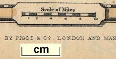
Scale of Mileschequered in miles, labelled 1,2,4,6,8 10 miles. The 10 miles = 19.1 mm giving a scale 1 to 842588 assuming a statute mile. The map scale is about:-
1 to 840000
13 miles to 1 inchUsing the scale of latitude another estimate of the scale can be got. 1 degree latitude = 129.2mm gives a scale 1 to 861597. The map scale is about:-
1 to 860000A good estimate of the real scale of the map can be made by reading the positions of a number of towns and comparing these to their known positions. DISTTAB.exe software is used to do the sums. The map scale is calulated as:-
1 to 870000The accuracy of the scale line is estimated:-
1 map mile = 1.05 statute miles

Printed in the map borders, which are tinted pale brown, are scale of latitude and longitude; chequered in minutes, labelled at 5 minute intervals. The projection is decidedly odd, trapezoid, but upsidedown; the longitude scale at the top is wider than the scale at the bottom! The ratio of the bottom (S) scale to top (N) scale is 0.94, it should be about 1.02.
The ratio of latitude/longitude scales is 1.61; this is close to the value to produce a 'square' map, 1.58 at latitude 51d N.
Measured from the map as well as can be, the:-
longitude, Winchester: 1d 16.6m WSuggesting a prime meridian about 2 degrees W of Greenwich.

Explanation.
Turnpike Roads ... [double line]
Rail Roads ... [bold line]
Rivers ... [wiggly line]
Canals ... [triple line, light bold light]
Boundary of Counties ... [dotted line]
sea plain
THE ENGLISH CHANNEL
CHRISTCHURCH BAY
coast form lines
harbours

The coast line emphasized by form lines and tinted blue. The form lines are continued in estauries and harbours. Harbours are recognisable, but not labelled.

Rivers are drawn by a wiggly line tapering upstream. None are labelled. All the major river systems of the county seem to be represented, with numerous tributaries.
forests
NEW FORESTis labelled as an area.

A number of parks are shown in outline, with a suggestion of fence plaings. The areas are tinted green, but the tinting of the whole map is poorly done, parks are most slap dash. Parks include modern estates as well as some of the old emparked areas, and are mostly [all?] unlabelled.
BERKSHIREEach county has its own tint: Hampshire yellow, Wiltshire green, Berkshire magenta, Surrey blue, Sussex magenta. Notice that this is 1 more colour than is needed. The detached part of Hampshire in Sussex is shown, interrupting the right border of the map, unlabelled, but coloured to match Hampshire. Quite a lot of topographic detail is shown in the adjacent counties, but less densely than in Hampshire.
town

WINCHESTER

LYMINGTON
STOCK-BRIDGE
hamlet

Upr. Wallop / Lr. Wallop
Hartley
Lyndhurst

Roads are drawn by a double line. They are all declared to be turnpike by the table of symbols, but this may not be so.

Canals are drawn by a curvy triple line, light bold light. None are labelled, but it is possible to recognise:-
Basingstoke Canal
Andover Canal [not through to Southampton]
Salisbury and Southampton Canal
Itchen Navigation
Titchfield Canal
the Portsea Island canal

London and South Western Raily.When the map was made, 1835, the London and Southampton Railway had not been built, though its route was known from its Act of Parliament passed 1834. It was renamed the London and South Western railway in 1839, and opened throughout in 1840.


Published in another edition 1842.


