
 Map Group PINE 1739

Plates 5 and 6 are on one sheet, plates 7 and 8 together on another sheet.
On each chart there is part of the coast of Hampshire with limited topographic detail. Plates 6 and 7 show the same area around the Isle of Wight. Plate 5 is to the east, plate 6 to the west.
Plates 5, 6 and 8 each show 2 battle scenes at different times.
Remember that these notes have a bias towards Hampshire interest.


set down in my mother tongue all that befell that summer upon the seas between the fleet of our noble and gracious Queen, and that of the King of Spain.
Tapestry Hangings of the House of Lords to which are added from a book entitled 'Expedionionis Hispanorum in Angliam Vera Descriptio AD1588' .. ten charts of the sea-coasts of England ... ornamented with medals struck on that occasion and other suitable devices. ...


publisher
H Gavelot delin. Publish'd by John Pine, June 24. 1739. according to Act of Parliament J. Pine Sculp.
SR. FRANCIS DRAKEBottom middle of border; an officer distributing booty? left - prisoners being taken off towards a castle; right - 3 ships at anchor
And medallions with mottoes around; top left, 3 ships:-
SED NOMINI TUO AD GLORIAMtop right, coat of arms, lion rising from the sea:-
NON NOBIS DOMINE NON NOBIS 1588 bottom left, lady in a chariot with ?palm and a book:-
TANDEM BONA CAUSA TRIUMPHAT 1588the book reads:-
ONSE UWEN
VADE NAEH
INDE- WERD
HEME GEHEY
sea plain
coast form lines
headlands
Some headlands, etc, are labelled, eg:-
Barry Point
Portland Bill
Mewstone
castles
Powderham Castle
Portland Castle
Sanderfoot Castle
PART OF DEVON SHIRE
PART OF DORSET SHIRE
town walls
EXETERdrawn with a town wall, with bastions.
Weymouth
Lyme
compass rose

There are two compass roses; each shows cardinal, half cardinal, and false points by star points, North is marked by a fleur de lys.

A winged cherub's head puffs to indicate wind direction at the time of the action.
sea plain
sandbanks
Some rocks and sandbanks are marked, some labelled, eg:-
Needles
Shingles

Horse
coast form lines
headlands

The coast line is drawn with form lines and has hachuring to indicate cliffs or a steep shore.
Some headlands, etc, are labelled, eg:-
Bill of Portland
Dunnose
castles
fortifications
Portland Castle
Corfe Castle
Hurst Castle

Calshot Castle
St Andrew's Castle
Portcaesarand on the Isle of Wight at:-
Yarmouth
Cows
Sandham Fort [IoW]Portsmouth, and the edge of Southampton, are shown by a star symbol which (I think) represent polygonal fortifications.
bridges

River estuaries are drawn with form lines, and then the river is drawn by a wiggly line going tapering inland. The rivers are not named.
A few bridges are shown.
hillocks

Relief is not treated seriously; many little hillocks are drawn on the land, but they are just scattered about as decoration. Corfe Castle is shown on its hill; the range of hills across the Isle of Wight is more carefully defined.

Tree are drawn on the land. But, as with hillocks, it looks as if they are just decorative.

The county boundary is a fine dotted line; the county areas are labelled, eg;-
PART OF HAMP SHIRE
Christchurch

Limmington
SOUTHAMPTON
Gosport

PortsmouthThe star shape indicates fortifications.


publisher
H Gavelot delin. Publish'd by John Pine, June 24. 1739. according to Act of Parliament J. Pine Sculp.
Sr. M. FORBISHER [sic]
Sr. JOHN HAWKINSBetween the 2 charts an angel leans on a shield inscribed:-
Ld. Tho. Howard
Lord Sheffield
R. Townsend
C. I. Hawkins
C. M. FrobisherAt the bottom Lord Howard knights some of his men; this included Hawkins and Frobisher, 5 August 1588.
compass rose

There is a compass rose showing cardinal, half cardinal, and false points by star points. A fleur de lys marks north.

A winged cherub's head puffs to indicate wind direction.
tides
sandbanks
The rough water off Portland Bill, caused by the tidal stream, is marked by waves, labelled:-

Race of PortlandSandbanks are noticed, eg:-

Shingles
coast form lines

The coast line is drawn with form lines and has hachuring to indicate cliffs or a steep shore.
castles
antiquities

Hurst CastlePortchester castle is marked and labelled:-

Portcaesara roman fort!

The county boundary is a fine dotted line; the county areas are labelled, eg;-
PART OF HAMP SHIRE
Christchurch
Limmington
SOUTHAMPTON

Gosport

Portsmouth
sandbanks
Owersand:-
The Horseis marked and labelled off Portsea Island.
Portsmouth
Havant


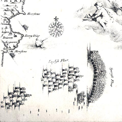
The scene shows the two fleets, clearly labelled:-
English Fleet
Spanish Fleetoff Berry Point, Devon, 1 August 1588.
The wind is from the west south west.
The Spanish are in their crescent battle formation, a mass of great ships; their flag is an X cross. The English, in open array, are chasing from windward; their flag is the cross of St George. Part of the english fleet is still lagging behind, perhaps a result of Drake leaving his station as a marker for the fleet during the night to take a rich prize in the morning, the Rosario. Two english ships are taking the abandoned spanish San Salvador, which is shown smoking after a crippling accidental explosion the day before. She was taken into Weymouth.
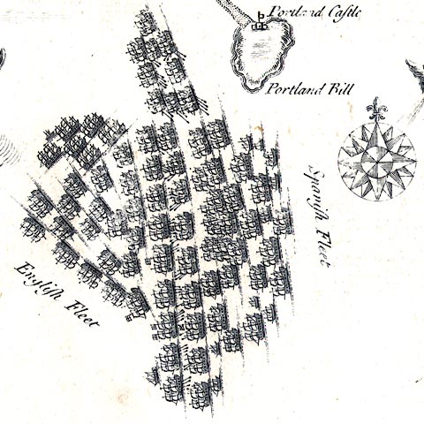
On 2 August 1588 the wind was from the north east in the morning, giving the Spanish the weather gage ie they were upwind of the English, an advantage. The Spanish attacked. The ships in the two forward lines of the two fleets are shown firing at each other - drawn by lines with a cannonballs at the ends coming from the ships. In the lee of Portland bill another group of english ships fire on the spanish north flank. (Pine's drawing does not show the action of spanish galleases attacking the detached Triumph and others as in the Adams charts.) During the day the wind went round to the south west again.
PROGRESS OF THE ARMADA, PLATE 6
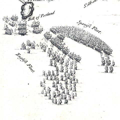
The action of 2 August 1588 is continued off Portland. The wind has shifted to south west. The action between Triumph and spanish galleases is still fierce close to Portland Bill; the main battle is now east of Portland.
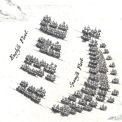
The weather was calm, light winds from the south west, by 3 August 1588. The English are formed in four squadrons pursuing the Spanish in their crescent formation, south of the Isle of Wight. The squadrons were commanded by Howard, Drake, Frobisher and Hawkins. The light wind inhibited action. Meanwhile small ships had been sent to shore for munitions (not shown in this scene; nor is an action against the Gran Grifon).
PROGRESS OF THE ARMADA, PLATE 7
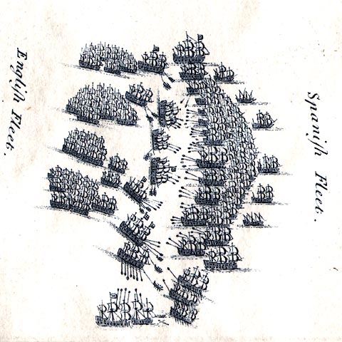
4 Augusts 1588, the two fleets are engaged in battle south of the Isle of Wight. The english fleet is in four squadrons; some ships are being towed towards the spanish fleet by rowing boats - the south west wind was so light. Some of the english ships are shown broadside on to fire their cannon. (The drawing fails to show ships in the south wing of the spanish fleet turning towards the attack there by Drake, which is clearly shown on the Adams chart.) Drake's attack on the seaward hoped to drive the Spanish north onto the Ower Banks, but this did not work. The Spanish disengaged. The encounter was indecisive; both sides used a lot of ammunition to little effect.
PROGRESS OF THE ARMADA, PLATE 8
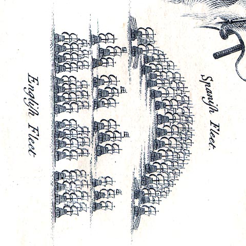
From 5-6 August 1588 the two fleets trailed eastwards along the channel towards the Straits of Dover. The Spanish in their battle crescent are pursued by the English in four squadrons. The Spanish were hurrying to their rendezvous to support the invasion by the Duke of Parma across the channel. They were still on course and undeterred by the English.
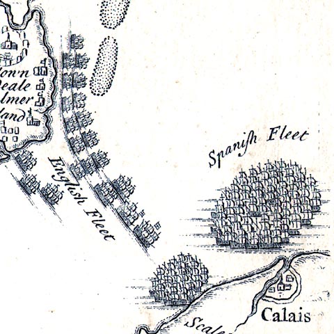
By 6 August the Spanish had anchored off Calais and decided to wait in this exposed spot for the invasion force of Parma - who was not ready. If they advanced to a safer anchorage they would have been unable to beat to windward to support Parma's crossing later. The English are anchored off Calais Cliffs. Seymour's squadron is shown sailing from his protective patrol off Kent, called by Lord Admiral Howard to his support. A council of war that day planned an attack by fireships ...


: 1919: Lord Howard of Effingham and the Spanish Armada with exact facsimiles of the Tables of Augustine Ryther, AD1590, and the Engravings of the Hangings in the House of Lords by John Pine, AD1739, ...: Roxborough Club
: 1988: Armada 1588-1988: Penguin Books & National Maritime Museum:: ISBN 0 14 010301 5; has reproductions of all the Adams/Ryther charts and the tapestry designs.
Martin, Colin & Parker, Geoffrey: 1988: Spanish Armada, The: Hamilton, Hamish:: ISBN 0 241 12125 6
Pine, John: 1739: Tapestry Hangings of the House of Lords: (London)
Ryther, Augustine: 1590: Discourse concerning the Spanishe fleete invadinge Englande in the year 1588 ...: (London)
Schrire, David: Adam's and Pine's Maps of the Spanish Armada: Map Collector's Circle
Ubaldini, Petruccio: 1588=1590: Expeditionis Hispanorum in Angliam vera Descriptio Anno Do MDLXXXVIII


