 Map Group CARY 1815

Although printed on one sheet the map is displayed in sections, with adequate margins between each so that the page can be folded without spoiling the map detail. The coast line, county boundaries, and roads are connected across the margins by straight lines to aid the eye. In spite of this the map has, as usual, suffered in use, becoming crumpled and in danger of tearing. The arrangement of sections is, in rows from the top, of 3, 4 and 4 panels, 11 sections altogether.
The map and the Itinerary studied are in the Map Collection, Hampshire CC Museums Service, items HMCMS:B1990.1794.1 and HMCMS:B1990.1794 respectively.


circular cartouche
map maker
A NEW MAP OF ENGLAND AND WALES, ADAPTED TO CARY'S NEW ITINERARY, SHEWING the Whole of the Roads Direct & Cross CONTAINED In that Work.Printed at the bottom is:-
London: Published by J. Cary Engraver and Map seller, No.181 Strand
up is N
scale
British Statute Milesgraduated and labelled at 5 miles intervals. From the scale line the scale is about 1 to 1306285. The map scale is about:-
1 to 1300000
21 miles to 1 inch
index map
Direct Roads [double line] Mail [double line, + shading] Cross Roads [single line]
Note The figures added to the Roads shew the route wherein they are describedThis map is an index map to the road book itineraries.
REFERENCES
ENGLAND
1 Cornwall
2 Devonshire
3 Somersetshire
...
7 Hampshire
...
40 NorthumberlandCounties are presented in a south to north, west to east order.
WinchesterLondon, the capital, has upright block caps.
village
Alton
Ringwood
BeaulieuVillages are probably only marked if they are nodes on the road network.
post roads
A junction might be labelled, eg:-
Lopton Cor.A road might be named, eg:-
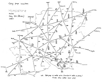
Popham LaneNumbers beside a road are route numbers, referring the user to a numbered itinerary in the road book; the map is an index map. This indexing is not done for all routes; the direct and post roads are mostly not numbered, cross roads, which one assumes are less well known, are.


Alton
Andover
Basingstoke
Bps. Waltham
Christchurch
Fareham
Fordingbri.
Gosport
Havant
Kingsclere
Lymington
Alresford
Odiham
Petersfield
Portsmouth
Ringwood
Romsey
Southampton
Stockbri.
Whitchurch
Winchester


post road: from London; through Bagshot and by the Golden Farmer, Surrey; then Blackwater, Hartford Bri., Basingstoke, Overton, Whitchurch, Andover, Hampshire; Lopton Cor. and Salisbury, Wiltshire; and on the Lands End.
branch from Andover, Hampshire; to Amesbury, Wiltshire; and beyond.
branch from Basingstoke, through Popham Lane, Sutton [Scotney], Stockbri., Hampshire; then Lopton Cor., Wiltshire, rejoining the Lands End route.
branch from basingstoke, through Popham Lane, to Winchester, Hampshire; continued from Winchester, through Romsey, Cadnam, Hampshire; joining the Poole Road in Dorset.
post road: branch from the Lands End road at the Golden Farmer, Surrey; across a corner of Hampshire; through Farnham, Surrey; then Alton, Alresford, Winchester, Southampton, Hampshire; continued from Southampton, through Totton, Cadnam, Ringwood, Hampshire; then Wimborne, to Poole, Dorset.
branch at the Hampshire/Dorset border direct to Poole, Dorset.
branch from Ringwood to Christchurch, Hampshire.
branch from Totton to Lymington, Hampshire
branch off the Poole Road after Alton, through Filmer Hill, Bps. Waltham, to Southampton, Hampshire.
branch off the Poole Road to Wickham, Fareham, Gosport, Hampshire; and a join from this road to Bps. Waltham.
post road: from London; through Godalming, Surrey; then Liphook, Petersfield, Horndean, Cosham, to Portsmouth, Hampshire.
branch off the London to Bath Road, [at about Aldermaston], Berkshire; to Kingsclere, Hampshire.


Title Page
CARY'S / NEW ITINERARY: / OR AN / ACCURATE DELINEATION / OF THE / GREAT ROADS, / Both DIRECT and CROSS throughout / ENGLAND AND WALES; / With many of the Principal Roads in / SCOTLAND. / From an ACTUAL ADMEASUREMENT by / JOHN CARY: / Made by COMMAND of his / Majesty's Postmaster General, / FOR / OFFICIAL PURPOSES. / Under Direction and Inspection of / THOMAS HASKER Esqr. / Surveyor and Superintendant of the Mail Coaches. / This WORK shows the IMMEDIATE ROUTE from the / METROPOLIS to all parts of ENGLAND and WALES: / AND / From Town to Town in every direction, distinguishing also, / THE / CITIES, MARKET, BOROUGH AND CORPORATE TOWNS: / And those at which the ASSIZES are held, and gives the time of / the MAILS ARRIVAL and DEPARTURE from each. Describes the / Line of the Navigable Canals and the Course of the Rivers passed over, / The Number of Houses and Inhabitants contained in each Town. / And those INNS which supply Post Horses and Carriages. / ALSO / The INNS throughout the METROPOLIS, from which the MAIL / And STAGE COACHES go, their time of departure, & the ROUTE they severally take. / The NOBLEMEN and GENTLEMEN'S SEATS situate near the Roads, / A List of the PACKET BOATS, and their Time of sailing: COPIOUS INDEXES. / Maps of the I. of Wight Environs of London Bath Brighton Margate & Cheltenham & a Large / Map of ENGLAND and WALES, peculiarly adapted to the Work. / SIXTH EDITION, with IMPROVEMENTS. / LONDON: Printed for J. CARY No. 181 Strand 1815.
Dedication page
DEDICATED / By Permission, / To The Right Honorable the / EARL of / Chesterfield, / THE / Liberal Patron of this Work, / BY / His Lordship's / much obliged, and / very obedient Servant, / John Cary, 1815.

HAMPSHIRE ROUTE DIAGRAM showing Cary page numbers:-


Cary, John: 1815 (6th edn): Cary's New Itinerary: (London)


