Coast line
Blome's Hampshire 1673
The sea area on Richard Blome's map has shading lines here and there, perhaps just to make it less 'empty'. One sea area is labelled - The Solent, called:-
PART OF YE BRITISH SEA
The coast line is shaded, pretty crudely. The shading is taken into harbours and river mouths. Mudflat or sandbank areas are stippled, and:-
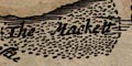
The Mackettis labelled south of Hayling Island.
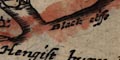
A few coastal features are labelled, headlands etc, eg:-
Hengist bury headSome harbours are labelled, eg:-
Black cliffe
Rames head
Hamble haven
Titchfeilde hav.
If the mapped coastlines are to be compared it might be helpful to lay them over each other. You might make each coastline conform to a common grid calculated for each map from data points over the whole county (this is the process used for other comparisons in this project). Or, you might calculate a common underlying structure just from recognizable fixed points along the coast: castles don't move, towns centres might shift a little, ... Do allow for gross as well as slight errors in the map maker's plotting.


