 |
Coastal defence, Castles
Blome's Hampshire 1673 |
|
 |
click for feature map
|
| coastal defence |
The three legs of The Solent, Southampton Water and Spithead
were the launching pad for medieval military expeditions to
the Continent, and in due course became the main base of the
Royal Navy. The area was equally liable to attack from the
Continent, and had to be defended.
Coastal defence castles are hardly noticed on Richard Blome's map.
Hurst castle is missing; so is the whole of Hurst Spit! The
defences shown listed below.
|
|
| castles |
BEWARE: to get back to this list after clicking on an item,
use the back button.
'modern' name (parish; ngr) = old name (hundred) if given
The list includes one inland castle.
|
 |
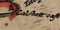
Calshot Castle (Fawley parish; SU488025)
= Calshott cast (Newforest Hundred)
|
|
|
Calshott cast (Newforest Hundred)
= Calshot Castle (Fawley parish; SU488025)
|
|
|
Castle of Malwood (Newforest Hundred)
= Malwood Castle (Minstead parish; SU277121)
|
|
|
Haselworth Castle (Gosport parish; SZ6198?)
= haselworth castle (Portesdowne Hundred)
|
|
|
haselworth castle (Portesdowne Hundred)
= Haselworth Castle (Gosport parish; SZ6198?)
|
|
|
Malwood Castle (Minstead parish; SU277121)
= Castle of Malwood (Newforest Hundred)
|
|
|
S Andrews Castle (Mansbridg Hundred)
= St Andrew's Castle (Hamble parish; SU4806?)
|
|
|
South castle (Portesdowne Hundred)
= Southsea Castle (Portsmouth parish; SZ6498)
|
|
|
Southsea Castle (Portsmouth parish; SZ6498)
= South castle (Portesdowne Hundred)
|
|
|
St Andrew's Castle (Hamble parish; SU4806?)
= S Andrews Castle (Mansbridg Hundred)
|


