Relief, Hills
Blome's Hampshire 1673
- important or isolated hills
- steep scarp
- uneven ground, hilliness
- high ground, ie altitude
- watersheds
A few hills are named, listed below.
'modern' name (parish; ngr) = old name (hundred) if given

|
|
Relief, HillsBlome's Hampshire 1673 |
|
|
click for feature map |
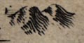
| Hills | Richard Blome could be using his hill symbol,
groups of hillocks generally shaded on the right, the east, to
show any of the following:-
A few hills are named, listed below. |
| hills |
BEWARE: to get back to this list after clicking on an item,
use the back button. 'modern' name (parish; ngr) = old name (hundred) if given |
|
|
Butser Hill (Langrish parish; SU7120) = Butter hill (Eastmeane Hundred) |
|
|
Butter hill (Eastmeane Hundred) = Butser Hill (Langrish parish; SU7120) |
|
|
Danebury Hill (Nether Wallop parish; SU3236) = Dunbury hill (Andover extra Hundred) |
|
|
Dunbury hill (Andover extra Hundred) = Danebury Hill (Nether Wallop parish; SU3236) |
  |
Blome's Hampshire 1673, contents |
|
|
feature list |
|
|
General index |
 |
Old Hampshire Mapped |