Parks
Blome's Hampshire 1673
'modern' name (parish; ngr) = old name (hundred) if given

|
|
ParksBlome's Hampshire 1673 |
|
|
click for feature map |
| Parks |
Parks on Richard Blome's map are drawn by a ring of fence palings.
Some contain trees. Few are labelled except by the house or
settlement within or near. Parks are listed below. |
| parks |
BEWARE: to get back to this list after clicking on an item,
use the back button. 'modern' name (parish; ngr) = old name (hundred) if given |
|
|
park (Old Basing parish; SU6654) |
|
|
Barapey (Basingstoke extra Hundred) = Beaurepaire Park (Sherborne St John parish; SU6358) |
|
|
Beaurepaire Park (Sherborne St John parish; SU6358) = Barapey (Basingstoke extra Hundred) |
|
|
Bedhampton Park (Havant parish; SU7008?) |
|
|
Bishops Waltham Park? (Bishops Waltham parish) |
|
|
Bramshill Park (Bramshill parish; SU7559) = Bramsill (Holdshott Hundred) |
|
|
Bramsill (Holdshott Hundred) = Bramshill Park (Bramshill parish; SU7559) |
|
|
Dogmersfield Park? (Dogmersfield parish) = Drogmers feild (Odiam Hundred) |
|
|
Drogmers feild (Odiam Hundred) = Dogmersfield Park? (Dogmersfield parish) |
|
|
East Meon Park? (Eastmeon parish) |
|
|
Elvetham Park (Hartley Wintney parish; SU85) |
|
|
Fareham Park (Fareham parish) |
|
|
Farleigh Park (Farleigh Wallop parish; SU6246) |
|
|
Freemantle Park (Hannington parish) = Fremantle parke (Kingesclere Hundred) |
|
|
Fremantle parke (Kingesclere Hundred) = Freemantle Park (Hannington parish) |
|
|
Grove place (Redbridge Hundred) = Grove Place Park? (Nursling and Rownhams parish; SU3616?) |
|
|
Grove Place Park? (Nursling and Rownhams parish; SU3616?) = Grove place (Redbridge Hundred) |
|
|
Hackwood Park (Winslade parish; SU6549) |
|
|
Hale Park (Hale parish; SU1818) |
|
|
Hambledon Park? (Hambledon parish) |
|
|
Highclere Park (Highclere parish; SU4459) |
|
|
Hursley Park (Hursley parish; SU4225) |
|
|
Hurstbourne Park (Hurstbourne Priors parish; SU4447) |
|
|
Marwell Park (Owslebury parish) = Maxwell (Fawley Hundred) |
|
|
Maxwell (Fawley Hundred) = Marwell Park (Owslebury parish) |
|
|
New Park (Brockenhurst parish) = Parke (Newforest Hundred) |
|
|
New Park (Old Basing parish; SU6651) |
|
|
Odiham Park (Odiham parish) |
|
|
Parke (Newforest Hundred) = New Park (Brockenhurst parish) |
|
|
Preuet park (Basingstoke extra Hundred) = Prewett Park (Sherborne St John parish; SU6153?) |
|
|
Prewett Park (Sherborne St John parish; SU6153?) = Preuet park (Basingstoke extra Hundred) |
|
|
Pylewell Park (Boldre parish; SZ3596) |
|
|
Rotherfeild (Alton and Sutton Hundreds) = Rotherfield Park (East Tisted parish; SU6932) |
|
|
Rotherfield Park (East Tisted parish; SU6932) = Rotherfeild (Alton and Sutton Hundreds) |
|
|
Silchester Park (Silchester parish; SU66) |
|
|
Southwick Park (Southwick and Widley parish) |
|
|
Stratfield Saye Park (Stratfield Saye parish; SU7061) |
|
|
The Vine (Basingstoke extra Hundred) = Vyne Park (Sherborne St John parish; SU6356) |
|
|
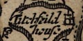
Titchfield Park (Fareham parish; SU5307) |
|
|
Vyne Park (Sherborne St John parish; SU6356) = The Vine (Basingstoke extra Hundred) |
|
|
West Park (Rockbourne parish; SU1116)
|
References |
Bilikowski, K: 1983: Historic Parks and Gardens: Hampshire
CC (Planning Dept):: ISBN 0 900908 79 3 Prosser, G F: 1833: select Illustrations of Hampshire ... Seats of the Nobility and Gentry; Gentlemen's seats in Hampshire: Arch, J and A (London) Shirley, Evelyn P: 1867: Some Account of English Deer Parks: John Murray |
 |
Blome's Hampshire 1673, contents |
|
|
feature list |
|
|
General index |
 |
Old Hampshire Mapped |