Scale line
Blome's Hampshire 1673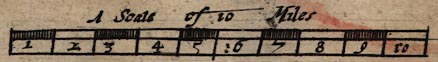
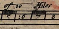
Printed lower centre is:-
A Scale of 10 Mileschequered and labelled in miles. The 10 miles = 65.1mm gives a scale 1 to 247211 on the bad assumption of a statute mile. The map scale is about:-
1 to 250000A better estimate of the map scale, with a note about the Old English Mile, has been made by comparing the positions of 21 market towns on Blome's map and today. The measured average scale is:-
4 miles to 1 inch
1 to 388167The range of scales is large; from 3.95 to 7.63 statute miles to 1 inch.
6.13 statute miles to 1 inch
According to its own scale line the map scale is 4.83 map miles to 1 inch, ie apparently 1 to 306087. The miles on the map's scale line are not statute miles but Old English Miles. From Richard Blome's map the:-
old english mile = 1.27 statute miles


