 |
miscellaneous
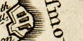
Kitchin's Hampshire 1767 |
|
| miscellany |
Thomas Kitchin's strip maps show incidental features beside the
road, what the tourist might or should notice, perhaps.
|
|
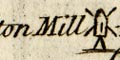
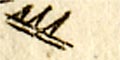
windmills: a post mill (eg: pl.30 m.61):-
Charlton Mill
There is another at Alton.
|
|
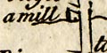
water mills: A water mill is labelled near Southampton
(eg: pl.55 m.3):-
a mill
There is a 'paper mill' elsewhere.
|
|
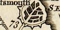
fortifications: Fortifications are drawn to suggest
polygonal style walls around Portsmouth (eg: pl.30 m.73). At
Portsey Bridge guarding Portsea Island the wall is labelled:-
a Fort
There are fortifications around Gosport and around the naval
base on Portsmouth Common (eg: pl.30 m.72). Kitchin shows more
fortifications in this area than his predecessors.
|
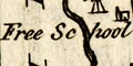 |
schools: At Alton (eg: pl.55 m.50) is:-
Free School
which is Eggars School.
|
|
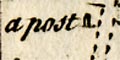
posts: There is a post drawn at 'Bluck on the Heath'
near Romsey (eg: pl.55 m.10) labelled:-
a post
|
|
crosses: There is a cross drawn at Picket Post near
Ringwood (eg: pl.50 m.94) with no label.
|
|
antiquities: The three tumuli of Popham Beacons are copied
in an unlikely shape (eg: pl.58 m.57) with no labelling. It feels
as tho' the engraver had no idea what he was drawing. They are
fairly indeterminate on Ogilby's map (pl.53) a hundred
years earlier.
|
|
inns: Inns are not much noticed but there are one or
two references. A turning is labelled:-
to Skippords Inn
from the road near Oakley. And:-
the Hutt
is labelled near Lopcomb Corner.
|
|
race courses: The race course on the downs above
Salisbury, Wiltshire, is indicated by several labels:-
The Race
the Stand
|
|
gallows: A mile short of Kingston, Surrey, near Richmond
Park, on the road from London to Portsmouth (pl.30 m.11) is a
drawing labelled:-
Gallows
|


