 |
Road map features
Kitchin's Hampshire 1767 |
|
|
A few images can be clicked for more information. |
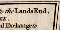 |
title cartouche: The beginning of each route has a title
in a plain box, the sides curved to fit within the scrolls of
the route maps. Only the first plate of a long road has a
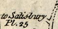
title cartouche giving the name of the road. Plate 25 for
example:-
The ROAD from LONDON to the Lands End, / in CORNWALL. / Containing
from the Royal Exchange to / ...
followed by a table of distances.
|
|
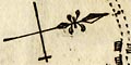
north point: Each strip has a north point, marked with a
spear point for north, and a cross line marked with a cross for
east. The orientation of the route maps is up is 'out from London',
as you journey from town you look up to what is before you.
(eg: pl.41 m.23)
While the general bearing of the route can be taken from the compass
the actual direction of a stretch of road is not so certain.
The wiggles in the road are probably 'compressed' sideways to fit
within the scrolls.
|
|
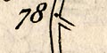
scale: The maps have no declared scale. It is possible,
but risky, to estimate the scale by measuring 1 mile
intervals marked on the roads (eg: pl.50 m.78), and averaging
... The average scale is about:-
1 to 160000
2.5 miles to 1 inch
but remember this is just an estimate and the plates seem to have
different scales.
|
|
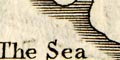
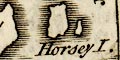
coast shaded: The coast line is shaded (eg: pl.55 m.0).
At Portsmouth the sea is labelled:-
THE SEA
Portsmouth Harbour
and an island (eg: pl.30 m.70) is labelled:-
Horsey I.
Kitchin has drawn the west coast of Portsea Island, three of the
islands in Portsmouth Harbour, and Gosport on the opposing coast.
This is more than was drawn by his predecessors.
|
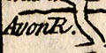 |
rivers: Rivers are shown by a wiggly line crossing a road;
or alongside a road. A large river may be drawn wider with form
lines, eg the Thames and Portscreek. A few rivers are labelled,
(eg: pl.50 m.101):-
Avon R.
Itchin Flu.
Black Water
|
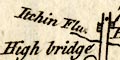 |
bridges and ferries: Bridges are presumably taken
for granted; a road over interupts the wiggly line of the river.
A bridge might be labelled, (eg: pl.55 m.71):-
High bridge
Portsey Bri
At Southampton, by the Itchen is:-
Ferry
|
|
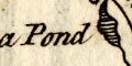
ponds: A pond is marked between Enfield and Romsey,
labelled:-
a Pond
Alresford Pond is shown similarly (eg: pl.55 m.59).
|
|
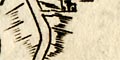
hills: Relief along the road is indicated by hillocks; it
remains an open question just what is being indicated
(eg: pl.58 m.59). The hillock may be across the road suggesting
a slope, up or down is not distinguished. There might be
hillocks either side of the road suggesting a valley, as
running into N Bavant in Wiltshire. They might suggest a ridge
(eg: pl.55 m.47) but we think this is just the engraver running
hillocks together. The hills might be spread around
decoratively suggesting hilly country (eg: pl.25 m.64).
|
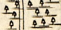 |
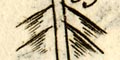
woods & forests: Woodland is suggested by little
tree symbols (eg: pl.55 m.53). A wood might be labelled, eg:-
Anstrey Wood
|
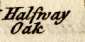 |
trees: A single tree might be labelled, even if not drawn
(eg: pl.55 m.4):-
Halfway Oak
Halfway from Southampton to Romsey.
|
|
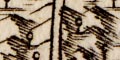
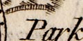
parks: Parks might be shown by some of a ring of fence
palings. This might be labelled, (eg: pl.25 m.61):-
Park
with a length of fence by the road before and after, on the right,
just beyond Whitchurch.
|
|
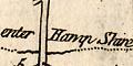
county: County boundaries are drawn by a dotted line across
the road (eg: pl.50 m.5). This boundary is also marked by a stream.
At these borders there is generally a statement like:-
enter Hamp Shire
County names are labelled alongside each length of road,
(eg: pl.30 m.45):-
HAMP SH.
|
|
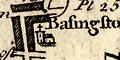
settlements: Settlements are drawn with blocks or groups
of blocks, perhaps laid out in streets in larger towns.
|
|
roads: Roads are the main element of these maps. The
road distance from London is given each mile.
|
|
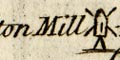
miscellaneous: Thomas Kitchin's strip maps show incidental
features beside the road, what the tourist might or should
notice, perhaps. There are a few: inns, windmills, race
courses, fortifications, schools, ...
|


