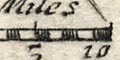
scale line
Morden's playing card map, Hampshire, 1676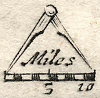
Morden's playing card map of Hampshire has a scale line with a pair of compasses above. The scale of 10 miles is chequered at one mile intervals, labelled at 5 and 10 miles. Its length is 10.3mm, assuming a statute mile the scale is 1 to 1562470. The map scale is about:-
1 to 1600000 ?A better estimate of scale can be amde from town positions, comparing known town-town distances, using DISTAB.exe. The map scale is about:-
25 miles to 1 inch
1 to 1800000 ?The map maker's miles are probably an old English mile = 1.15 statute miles BUT on such a small map this is not a reliable estimate of the Old English Mile.
27.5 miles to 1 inch


