| Trees, Woods, Forests
Norden's Hampshire 1607
|
|

| click for feature map
|
| Trees
|
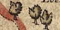
Trees, on Norden's map of Hampshire, are shown outsize pictures
of trees. Many of the trees appear to be no more than decoration
- but as this symbol probably has a low priority the distribution
cannot be taken with to be very reliable or significant. One
single tree is named, the Lomer Ash. The trees sometimes
seem to be grouped into woods or forests; in many cases these
groupings can be identified with the royal forests of a previous
age. Forests on Norden's map are listed below.
We have not tried to match the groups of trees to present day woods.
|
|
| forests |
BEWARE: to get back to this list after clicking on an item,
use the back button.
'modern' name (parish; ngr) = old name (hundred) if given
|
 |
Bagshot Forest
|
|
|
Buckholt Forest
= Buck Holt Forrest (Thornegate Hundred)
|
|
|
Chute Forest
= Chure Forrest (Andover extra Hundred)
Note in Camden's Britannia
|
|
|
East Bere Forest?
= Forrest of Beare (Portesdowne Hundred)
Note in Camden's Britannia
|
|
|
Eversley Forest - perhaps
|
|
|
Linwood Coppice (Bramshaw parish; SU2414)
= Lynwood (Newforrest Hundred)
|
|
|
Lomer Ash (Exton parish)
= Lomer Ash (Fawley Hundred)
|
|
|
New Forest
= New Forrest (Ringewood Hundred)
Note in Camden's Britannia
|
|
|
Pamber Forest (Pamber parish; SU6161)
Note in Camden's Britannia
|
|
|
Stansted Forest
|
|
|
West Bere Forest
= Weste Forrest (Budlesgate Hundred)
|
|
|
Woolmer Forest (Whitehill parish; SU8032)
= Wvtmer Forrest (Alton Hundred)
|
|
Notice the name of West Bere Forest, called 'Weste Forrest'.
The 'Beare' has got detached and misplaced, engraved to make
the village of Weeke into 'Beare week'.
|


