 |
Road map features
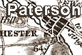
Paterson's Hampshire 1785-93 |
|
|
A few images can be clicked for more information. |
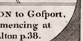 |
title cartouche: The beginning of each strip map, at
the bottom of the first strip, is a semicircular cartouche with
the route's title (eg: vol.1 p.68 mile 48):-
LONDON to Gosport, commencing at Alton p.38.
Page 38 is where to the way from London to Alton is found, part
of another road. Other road titles give the start point for
distances (eg: vol.1 p.29):-
LONDON to Portsmouth, measured from the Stones-end in the
Borough.
|
|
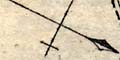
north point: Orientation is indicated for each section of
road; a line with a spear point for north, and a line across
with a cross for east. The strip maps are drawn with the direction
of travel going up the page, ie up is forward.
(eg: vol.1 p.31)
Contrasted to earlier strip maps Paterson's are more like strips
cut out of a 'normal' topographical map. They include a great deal
of surrounding detail and the direction of each piece of road is
meant to be true.
|
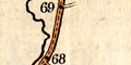 |
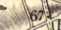
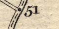
scale: The strip maps have no explicit scale; roads are
marked with a numbered dot at 1 mile intervals. A scale can
be estimated; about:-
1 to 181000 = 3 miles to 1 inch
|
|
coast form lines & harbours: The coast is engraved with
form lines following into harbours and up river mouths.
Harbours are indicated, and may be named, (eg: vol.1 p.69 mile 75):-
PORTSMOUTH HARBOUR
The sea might be labelled, eg:-
THE SEA
|
|
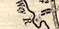
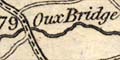
rivers & bridges & ponds & ferries: Rivers are shown as a
wiggly line which broadens towards its mouth, where it is drawn
with form lines. The river may be named, (eg vol.1 p.37 mile 40):-
Wey R, Thees R.
Bridges are not clearly indicated, but are implied by the river
being interupted by the road it crosses. A bridge might be named
(eg: vol.1 p.39 mile 79):-
Oux Bridge
A pond may be drawn, perhaps labelled, eg:-
Fleet Pond
Or not as at Alresford Pond (eg: vol.1 p.43 mile 57).
|
|
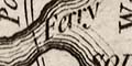
ferries:
A ferry might be drawn by a dotted line across a river, and
labelled, (eg vol.1 32 mile 0):-
Ferry
across the 'Itching' by Southampton.
|
|
relief & hill hachuring: Little attention is given to
gradients on the roads. Relief is indicated by hachuring, and this
might imply a hilly road, for example near Lopcombe Corner west
of the Wallops. Some hills are labelled, eg:-
Salisbury Plain
Deanbury Hill
Ports Down
At the last the map shows the road dropping off the hillside
towards Portsea (eg: vol.1 p.33 mile 67).
|
|
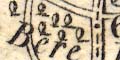
woods & forests: There are occasional groups of trees drawn
to indicate woods or a forest. These might be labelled,
(eg: vol.1 32 mile 63):-
Bere Forest
|

|
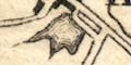
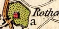
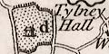
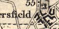
parks & houses: Parks are shown by a ring of fence palings,
the drawing indicates the size and shape of the park. The interior
is dotted and usually contains a house (eg: vol.1 p.69 mile 52):-
d Rotherfield
e Hackwood Park, D. of Bolton.
Not all the grounds drawn like parks are old emparked areas.
In some instances the house name or the gentleman's name is drawn
by the park in the map (if assembling a list of names do not rely
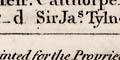
only on the footer lists). In other instances there is a letter
beside the house keying it to information in the page footer
(eg: vol.1 p.45 mile 45 and footer):-
d Tylney Hall
... d Sir Jas. Tylney Long ...
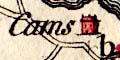
Not all houses are in grounds (eg: vol.1 p.69 mile 73):-
b Cams
And a splendid castle is drawn at Powderham (eg: vol.1 p.38 mile 41):-
Powderham C.
|
|
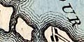
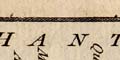
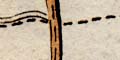
county: Counties are labelled along the edge of a strip,
(eg: vol.1 p.71 mile 69):-
HANTS
A county boundary is shown by a dotted line where it crosses the
road, in some cases this is labelled, eg:-
Enter Dorset
But in other instances it is unlabelled (eg: vol.1 p.71 mile 72),
and might even be missed altogether.
|
 |
settlements & streets: Settlements are shown by blocks and
groups of blocks arranged along streets or the road. The size of
the group indicates the size of the place.
|
 |
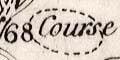
roads: Roads are the reason for these maps, but the route
being drawn is less prominent than in earleir road books. The road
is surrounded by more detail of the countryside. The route for each
strip is the familiar double line PLUS a dotted line down the centre to mark its importance.
|
 |
miscellany: Daniel Paterson's strip maps show incidental
features beside the road, what the tourist might or should
notice, perhaps.
|


