 |
miscellaneous
Paterson's Hampshire 1785-93 |
|
miscellany
|
Daniel Paterson's strip maps show incidental features beside the
road; what the tourist might or should notice, perhaps.
|
|
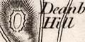
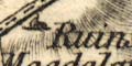
antiquities & hillforts: Occasional antiquities are drawn,
for example Danebury has a structure drawn on top of the hill which
is labelled (eg: vol.1 p.69 mile 69):-
Deanbury Hill
and (eg: vol.1 p.43 mile 63):-
Ruins of Magdalane Chapel
Are drawn on Magdalen or Morning Down, on the lovely route
into Winchester from the east.
|
|
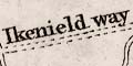
roman roads: A dotted double line is used for roman roads;
which might be labelled, (eg: vol.1 p.45 mile 63):-
Ikenield way
which runs southward, on the east of Andover, from the:-
Port Way a Roman Way to Silchester
|
|
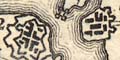
fortifications: Angular, polygonal artillery style,
fortifications are drawn at Portsmoutha and Gosport
(eg: vol.1 p.33 mile 72), with Haslar Hospital shown with towers
at its four corners.
|
|
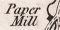
paper mills: A paper mill is labelled at Whitchurch
(eg: vol.1 p.45 mile 56):-
Paper Mill
This is an important paper mill. No other water mills or windmills
have been noticed in Hampshire (yet).
|
|
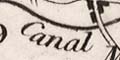
canals: Canals are drawn by a single curvy line, labelled,
near Hook, (eg: vol.1 p.45 mile 39):-
Canal
|
|
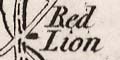
inns: A number of inns are labelled, for example on the road
west of Newnham, about mapledurweel, is (eg: vol.1 p.45 mile 41)
the:-
Red Lion
|
|
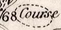
race course: Several race courses are shown, for example west
of Stockbridge, a dotted ring for the course, labelled
(eg: vol.1 p.69 mile 68):-
Course
|


