| Coastal defence, Castles
Saxton's Hampshire 1575
|
|

| click for feature map
|
|
coastal defence
|
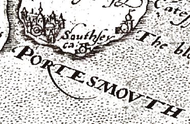
Saxton's map of Hampshire shows most of the active coastal
defence castles: Hurst, Calshot, Netley, St Andrew's,
Southsey and Lumps Fort east of Southsea. At Portsmouth
and Southampton it is possible, under the heavy red applied
by the colourist, to see town walls and bastions; for
example at Portsmouth:-
Norden's map of Hampshire, 1595-1607, marked the ruins of
Worth castle, but left off Lumps Fort. In the late 16th
century the possibility of invasion was real; the Armada
came in 1588.
|
|
| castles |
BEWARE: to get back to this list after clicking on an item,
use the back button.
'modern' name (parish; ngr) = old name if given
The list includes inland castles as well as the
coastal defences.
|
 |
Calshot Castle (Fawley parish; SU488025)
= Calshot castel
|
|
|
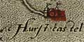
Hurst Castle (Milford-on-Sea parish; SZ3189)
= Hurst castel
|
|
|
Lumps Fort (Portsmouth parish; SZ657982)
= blockhowse, The
|
|
|
Netley Castle (Hound parish)
= Netley cast
|
|
|
Odiham Castle (Odiham parish)
= Wharnboro cast
|
|
|
Portchester Castle (Fareham parish; SU6204)
= Portchester
|
|
|
Southsea Castle (Portsmouth parish; SZ6498)
= Southsey ca
|
|
|
St Andrew's Castle (Hamble parish; SU4806?)
= Sct Andros cast.
|


