| Map features
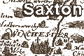
Saxton's Hampshire 1575
|
|
| Map feature
|
Some images can be clicked for more information.
|
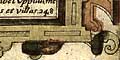
| title cartouche; strapwork plus ...
coats of arms, maker's name
|
| orientation; shown by labelled borders
|
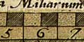
| scale line; 10 miles, chequered
engraver's name
|
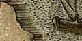
| coast shaded; into a stippled sea
|
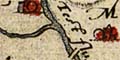
| rivers; shown by tapered wiggly lines
|
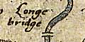
| bridges; shown by arches over rivers
|
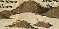
| relief; shown by hillocks shaded to east
|

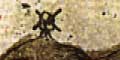
| beacons; some indicated by 'posts' on hills
|
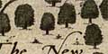
| woods, forests; shown by groups of trees
|

| parks; shown by rings of fence paling
|
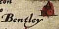
| settlements; places are shown by a dot
and circle, with added elements to indicate -
houses, hamlets, villages, cities, etc
|
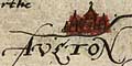
| market towns; and other towns, block caps label
|
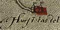
| coastal defence, castles; dot and
circle with towers and flag
|
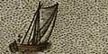
| decoration:
galleon - carracks and small craft; sea monster; etc
|
| miscellany:
picture frame border; swash lettering; engraving; windmill; etc
|


