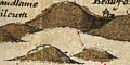
Relief, Hills

Saxton's Hampshire 1575

click for feature map
Hills Hills on Saxton's map of Hampshire are indicated by hillocks. These are mostly grouped, though it is not easy to interpret what they mean. Some hills are made steeper or bigger than others; some hills are named.

The hill symbol could show any of the following:-
  • important or isolated hills
  • steep scarp
  • uneven ground, hilliness
  • high ground, ie altitude
  • watersheds
- or they might possibly just be decoration, but we don't believe that. The drawing of hills has to compete with the placing other information on the limited map space. We do not know what priority was given to hills.


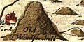
The first category of hills is clearly represented. An important or isolated hill might be the site of a fort, beacon, castle, or town. The hill might be named, for example Old Windsor hill.


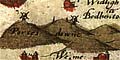
A steep scarp might be shown as a line of hills; example Portes downe. Some scarps are missed.


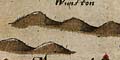
The line of hills drawn north of Winchester is not a scarp, but is high rolling downland, and is a watershed.

The other categories of hills seem to have a lower priority, and it is less clear what was intended. There seem to be more hillocks drawn where ground is high, say above 100m. In Hampshire high ground tends to be hilly ground. Low lying hilly ground seems to lack hillock symbols; but the space on the map is often taken up by trees in woods and forests.


hills BEWARE: to get back to this list after clicking on an item, use the back button.
'modern' name (parish; ngr) = old name if given
Old Winchester Hill (Exton parish; SU6420) = Old Windsor hill
Portsdown (Portsmouth parish; SU6_0_) = Portes downe
St Ann's Hill (Nether Wallop parish) = Sct An~s hill
Stoner Hill? (Froxfield parish) = Stone hill
Toothill (Nursling and Rownhams parish; SU3818) = Towte hill


Saxton's Hampshire 1575, contents
feature list
General index
Old Hampshire Mapped

Map HMCMS:KD1996.1