miscellany
Saxton's Hampshire 1575frame
border
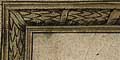
Saxton's map is engraved with a border that imitates carved wood picture framing.
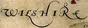
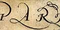
Empty space outside the county is filled with swash lettering, naming the contiguous counties.

Spaces within the map might also be filled decoratively.
The text engraving on this map is a delight; accurate and clear with a lovely feel to the letter spacing and decoration. Extended ascenders and descenders work between cartographic elements to please the eye.
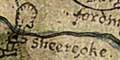
The map has had some very crude amendments to its plate. Perhaps the most blatant 'correction' is the addition of Fordingbridge and Burgate with a village symbol. Nearby the Sheereoke is added at the shire boundary. These additions are not well engraved, are rather naive.
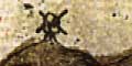
Windmills are drawn on the map, for example two on Portes down. The mills are post mills with four sails.
Hundreds
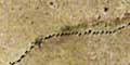
The county boundary is a finely dotted line. Contiguous counties area named. The detached part of Hampshire to the east is missed off the map.
Although hundreds remained an useful administrative unit, only 5 of Saxton's 34 county maps show them. This sheet, Hampshire, does not show the hundreds.
There is an unexplained area delimited by a red dotted line near around Cheriton, Kimston, Beauford, and Tichborn. This is not printed in black, and might have been inserted by the colourist.


