| Rivers
Saxton's Hampshire 1575
|
|

| click for feature map
|
| Rivers
|
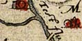
Saxton's map of Hampshire clearly shows its rivers; some of
them are named. All the major rivers are shown, but there
are some little streams shown which might have been left out,
and some not shown which might have been included. Keep in
mind that this map was produced for government; knowledge
of rivers is necessary to the planning of troop movements,
they are a serious barrier.
The style of drawing of rivers is schematic, drawn tapering
from their mouth. There is no excessive wiggliness but it
clear that rivers are represented. Braiding is indicated,
but is not an exact match to the rivers' [today's] courses.
The rivers that are shown can mostly be indentified, with
a degree of guesswork.
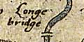
A number of bridges are indicated; they too are
important knowledge if movements are being planned.
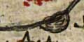
Harbours, havens, along the coast are labelled clearly.
Some ferries are noticed. At least one pond is shown, at
Alresford.
|
|
| rivers |
BEWARE: to get back to this list after clicking on an item,
use the back button.
'modern' name (parish; ngr) = old name if given |
 |
Alre, River (Itchen Stoke and Ovington parish; SU5732)
|
|
|
Anton, River (Wherwell parish; SU3839)
|
|
|
Ashford Water (Fordingbridge parish; SU1413)
|
|
|
Avon Water (Milford-on-Sea parish; SZ3091)
|
|
|
Avon, River (Christchurch parish; SZ1692)
= Avon flu
|
|
|
Bagwell Stream? (Hook parish; SU740543?)
|
|
|
Bartley Water (Totton and Eling parish; SU3612)
|
|
|
Beaulieu Haven (Beaulieu parish; SZ4398)
= Bewley haven
|
|
|
Beaulieu River (Beaulieu parish; SZ4297)
|
|
|
Blackwater River (Bramshill parish; SU7463)
|
|
|
Blackwater, River (Totton and Eling parish; SU3615)
|
|
|
Bourne Rivulet (Hurstbourne Priors parish; SU4445)
|
|
|
Bow Brook (Bramley parish; SU6758)
|
|
|
Buriton Stream? (Buriton parish; SU7521)
|
|
|
Cadnam River (Netley Marsh parish; SU3317)
|
|
|
Candover Stream (Itchen Stoke and Ovington parish; SU5631)
|
|
|
Christchurch Harbour (Christchurch parish; SZ1791)
= Christchurch haven
|
|
|
Criddell Stream (Petersfield parish; SU7723)
|
|
|
Danes Stream (Milford-on-Sea parish; SZ2991)
|
|
|
Dever, River (Barton Stacey parish; SU4041)
|
|
|
Ditchend Brook (Fordingbridge parish; SU1413)
|
|
|
Dockens Water (Ringwood parish; SU1406)
|
|
|
Dun, River (Mottisfont parish; SU3225)
|
|
|
Ems, River (Havant parish; SU7505)
|
|
|
Enborne, River (Ashford Hill with Headley parish; SU5563)
= Awborne flu
|
|
|
Hamble Haven (Hamble parish)
= Hamble haven
|
|
|
Hamble, River (Hamble parish; SU4804)
|
|
|
Hart, River (Bramshill parish; SU7460)
|
|
|
Itchen, River (Southampton parish; SU4209)
= Ichin flu
|
|
|
Kingsclere Stream? (Ashford Hill with Headley parish; SU5363)
|
|
|
Lin Brook (Ringwood parish; SU147058)
|
|
|
Loddon, River (Stratfield Saye parish; SU7063)
|
|
|
Lyde River (Sherfield on Loddon parish; SU6956)
|
|
|
Lymington Haven (Lymington and Pennington parish; SZ3394)
= Lemyngton haven
|
|
|
Lymington River (Lymington and Pennington parish; SZ3493)
|
|
|
Meon, River (Fareham parish; SU5302)
|
|
|
Oakhanger Stream (Selborne parish; SU7836)
|
|
|
Park Stream (Michelmersh parish; SU3432)
|
|
|
Pillhill Brook (Upper Clatford parish; SU3544)
|
|
|
Ports Creek
|
|
|
Portsmouth Harbour (Portsmouth parish)
|
|
|
Rother, River (Steep parish; SU7723)
|
|
|
Shedfield Stream? (Curdridge parish; SU529118)
|
|
|
Somborne Stream?? (Kings Somborne parish; SU3430)
|
|
|
Southampton Water
|
|
|
Stour, River (Christchurch parish; SZ1692)
= Stoure flu
|
|
|
Test, River (Southampton parish; SU4209)
= Test flu
|
|
|
Titchfield Haven (Fareham parish; SU5303)
= Tychfeld haven
|
|
|
Wallington River (Fareham parish; SU6003)
|
|
|
Wallop Brook (Houghton parish; SU338307)
|
|
|
Wey Brook (Sherborne St John parish; SU642584)
|
|
|
Wey, River (Binsted parish; SU8144)
|
|
|
Whitewater, River (Bramshill parish; SU7463)
= Ditford flu
|


