| Trees, Woods, Forests
Saxton's Hampshire 1575
|
|

| click for feature map
|
Woods and
Forests
and Trees
|
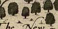
Saxton's map of Hampshire shows definite groups of
trees indicating forests, which are mostly named.
Undergrowth is also shown by little bushes. The
forests mostly correspond to the great hunting preserves
declared as royal forests; but not all. Trees are also drawn
in parks. The forests on Saxton's map are listed below.
We have not attempted to explore the relationships of all
groups of trees on the map with woods today.
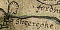
The version of Saxton's map in the Hampshire collection has ill-engraved additions to the plate. One of these is
the Sheereoke marking the meeting of shire boundaries
of Hampshire, Dorset and Wiltshire.
|
|
forests
woods
trees |
BEWARE: to get back to this list after clicking on an item,
use the back button.
'modern' name (parish; ngr) = old name if given |
 |
Alice Holt Forest (Binsted parish; SU8042)
= Alisholt forest
|
|
|
Buckholt Forest
= Buckholt forest
|
|
|
Chute Forest
= Chute hamshire forest
|
|
|
East Bere Forest?
= forest of Est Bere, The
|
|
|
Harewood Forest (Longparish parish; SU4044)
|
|
|
New Forest
= New forest, The
|
|
|
Pamber Forest (Pamber parish; SU6161)
= Pamber forest
|
|
|
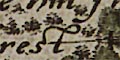
Shire Oak (Fordingbridge parish)
= Sheere oke
|
|
|
Sutton Beech Wood (Bishops Sutton parish; SU6233)
|
|
|
Waltham Forest
= Waltham forest
|
|
|
West Bere Forest
= West Bere forest
|
|
|
Woolmer Forest (Whitehill parish; SU8032)
= Wulmere forest
|


