| Map features
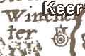
Keer's Hampshire 1605
|
|
| Map feature
|
Some images can be clicked for more information.
|
|
title cartouche; strapwork cartouche.
|
|
orientation; labelled borders.
|
|
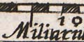
scale line; chequered scale line with the title
cartouche; about 16.5 miles to 1 inch.
|
|
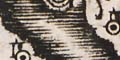
coast shaded; moire effect sea; and the coast shaded
with horizontal lines extended into harbours and river mouths.
|
|
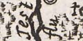
rivers; wiggly lines tapering in from the river mouth,
the lines stay quite wide and bold. Most rivers are not
named, but see:- Test flu.
|
|
bridges; some bridges are indicated, at
Romsey, Stockbridge, and out of the county.
|
|
relief; no relief is indicated on the map; except
Old Winchester Hill? near Catherington.
|
|
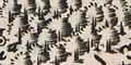
woods, forests; forests are clearly shown by groups
of trees.
|
|
county; dotted line
|

|
swash lettering; swag lettering is used to fill
space, labelling the adjoining counties and the sea area
south of Chichester.
|
|
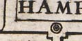
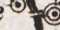
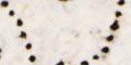
settlements; dot and circle, and building; labelled
|
|
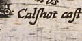
castle; dot and circle, and tower, like a village; the
sea defences, Hurst, Calshot, Netley and St Andrew's castles
are labelled.
|


