
 Map Group OS 1810s OLD SERIES


map maker
WinchesterThe sheet number is printed top right in roman numerals, eg:-
No. XIand on later editions is repeated in arabic numerals, above and to the right, eg:-
11Printed top left:-
Engraved at the Drawing Room in the Tower under the Direction of Lt. Coll. Mudge, by Benjn. Baker & Assistants - The Writing by Ebenr. Bourne. / Price Two ShillingsPrinted bottom:-
Published 10th. April 1810, by Lt. Coll. Mudge, Tower. / Printed from an Electrotype
up is N
meridian
Printed in the top and bottom borders of sheet 11 is a line marking the local meridian, labelled:-

Meridian of Dunnose Latitude 50[d]. 37[m]. 8[s]. / Longitude 1[d]. 11[m]. 36[s]. WestThe Meridian of Dunnose runs from Dunnose, Isle of Wight to Clifton, Yorkshire. It passes through Hampshire and used triangulation stations at Butser Hill and Highclere. Other nearby stations that made triangles with these were: Dean Hill, Wiltshire; Hindhead and Bagshot, Surrey; Whitehorse Hill, Berkshire; Nuffield, Oxfordshire. The triangulation is described by Mudge and Colby 1811.
Printed in the right border:-
Parallel to the Meridian at GreenwichThe maps have no scales of latitude and longitude by which to know where a place is, though accurate knowledge of this information is implicit in the plotting.
scale

Scale of Statute Milesmarked and labelled in miles, with a left extension marked and labelled in furlongs. The 5+1 miles = 149.1 mm gives a scale 1 to 64676. The nominal map scale is:-
1 to 63360
1 inch to 1 mile
sea plain
buoys
wrecks
STOKES BAY
SPITHEADbuoys are not marked generally, but a conical buoy is drawn in Spithead, labelled:-

Buoy of the Royal Georgewhich ship sank in 1782 and was still obstructing shipping in The Solent to the mid 19th century.
coast form lines
foreshore
headlands
sandbanks
coast appearance
lighthouses
harbours

The coast line is emphasized by elegant form lines. The engraving is in two stages: from the coast line out across the foreshore, reducing to nothing; from the edge of the foreshore out into the sea, reducing again. The engraving is eye catching, particularly around the channels in Portsmouth Harbour and the East and West Winner at the entrance to Langstone Harbour, sheet 11.
Channels in the foreshore are clearly marked, and occasionally labelled, eg:-
Ashlet Lake
Oar CreekRocks might be marked on the foreshore.
Where there are cliffs the coast line is drawn to show their appearance from the sea, for example west of Hengistbury Head and the coast off Milton.
Headlands are noticed eg:-
Needs Oar Point
Stone Point
Gilkicker PointThe shallows and channels and islands are drawn in the harbours, some of which are labelled, eg:-
PORTSMOUTH HARBOUR
Langston HarbourIn Portsmouth Harbour there are labelled:-
Pewitt Island
Horsea Island
Whale Id.
Porchester Lake
Fountain Lake
Fareham Lakeas well as the coastal features. Notice the use of 'lake' for channel. The term has two meanings, from two separate roots; here it means channel from its teutonic root.
On Hurst Spit there is labelled:-
Light House
castles
fortifications
Hurst Castle

Calshot Castle
Netley Castle
[fortification, Fort Gilkicker]
Barracks [at Haslar]
Haslar Hospital
[fortification, Fort Blockhouse]
[fortification, around Gosport]
Burrow Fort
Priddys Hard [and fortification]
[fortification, along Ports Creek]
[fortification on mainland at Ports Bridge]
Hilsea Redoubt
Hilsea Barracks
Magazine [Tipner Point]
[fortification, round Royal Navy dockyard]
[fortification, round Portsmouth]
S. Sea Castle
[fortification, Lumps Fort]
[fortification]

Cumberland FortOn a later edition of the 1 inch maps, government maps, the coastal defences are partly erased. The fortifications around Gosport and the dockyard and town at Portsmouth, are, for example, blanked out. Haslar Hospital and Priddy's Hard are gone, and so on.
ponds
watermeadows
bridges
ferries

Rivers are drawn with a double line sometimes with form lines, perhaps suggesting their true width? with the west bank engraved bolder, a shadow to the east or south east. Where narrower the river is drawn by a single wiggly line tapering upstream. Large and moderate size meanders should be plotted accurately at this scale; but remember that rivers are dynamic systems, and meanders do just that. Braiding is shown. Many rivers are labelled, eg:-
The Anton or Test R.
RIVER ITCHEN
Beaulieu River
Town Brook [Basingstoke]and some river mouths are labelled, eg:-
Bourne Mouthwhich is pretty near uninhabited at this date.
Above Stockbridge the Test/Anton is labelled Test; the river through Andover is labelled Anton; the stream through St Mary Bourne is labelled Test. This is not an unusual muddle.
A river flood plain might be engraved, perhaps by a roulette? to suggest tussocky meadows. Below Bossington a flood plain engraved like this is labelled:-

Water MeadThe map shows the complicated streams and artificial channels of the water meadows south of Downton, on the Avon.
Some springs are noticed, eg:-
Springs [S of East Meon]
Newram Springs [ESE of Basingstoke]Some ponds are drawn in outline and labelled, eg:-
Sowley Pond
Creech PondAn unlabelled pond might be unrecognised, it's just another shape. A pond in the flood plain of the Itchen, level with North Stoneham is labelled:-
Decoywhere there was a duck decoy for hunters.

Flash Pondon Beaulieu Heath uses a local word for a marsh or pond. On the stream 2 miles ENE of Southwick Park is a:-
SheepwashBridges are implied where a road crosses and interrupts a stream. Some are labelled, eg:-

Boldre Bridge [Lymington River]
Skidmore Bridge [Test]A ferry might be noticed, eg:-

Itchen Ferry
hill hachuring

Relief is indicated by hill hachuring, which, disentangled from other features, is moderately successful at giving a local impression of landscape; it does not show the shape of the country as a whole. The relationship of rivers to valleys, and roads to ridges, is often very clear. Some hills are labelled, eg:-
PORTS DOWN
Butser Hill
Bere Down
Toot HillAs well as hills some valleys are labelled, eg:-
Hollywell Bottom [W of Kingsclere]
Beacon Hill [Burghclere]
Beacon Hill [N of Exton]
Beacon Hill [NW of Dibden]and at least one is named:-

Bushy Beacon [ESE of Sarisbury Green]
forests
trees
vegetation
plantations

FOREST of BERE
Out Hurst Wood
In Hurst Wood
Holt Wood
Bells Coppiceall in the East Bere Forest area. Nearly all woods are shown with deciduous tree symbols. There are some fir trees noticed, eg:-
Fir Treesby an indeterminate symbol east of Catherington.
In a park the tree symbols might be drawn in avenues.
There is an unnamed plantation of fir trees, in rows, on The Barnet south of Colemore.
A few individual trees are labelled, not always attached to a particular tree symbol, eg:-

Wollaston's Willow [E of Bossington]
Marlpit Oak [S of Brockenhurst]
Bound Oak [W of Rowlands Castle]
Bound Tree [S of Dibden]
Yew Tree [E of Dibden]which last may just be descriptive, not a name, but it does have its own distinctive tree symbol, a fir.
A variety of land areas are labelled indicating their nature, eg:-
Blendworth Comn.
Creech Plain
West Heath [W of Pamber]
Hartford Bridge Flats
Wallop Fields
Peat Moor

At this scale parks are shown in some detail, for example:-

The county boundary is a bold dotted line; the line might be engraved less bold where it would spoil other engraving, eg the edge of Lady Holt Park east of Charlton on the Sussex border. Remember that these maps are not 'county' maps but parts of an overall survey of the country. Topographic detail is plotted allover the sheets, not stopping at, taking little notice of, county boundaries. The county is named, labelled on sheets 12 and 11:-
H A M P
S H I R E

in large block caps which are engraved to overlie hachures and land boundaries, but underlie settlements and roads; a pretty conceit.
The detached part of the county in Sussex is bounded, and labelled:-
PART of HAMPSHIRE
streets

WINCHESTERAmong the clutter is it is possible to pick out the cathedral, drawn in solid outline, and river streams.
PORTSMOUTH
SOUTHAMPTON

PETERSFIELD
STOCKBRIDGEThe leading capital being a little larger. Notice that Fordingbridge is downgraded to a village.

Hambledon
Hinton Ampner
East Worldham

Nurstead
Oakhanger
Neatham
Summer Ho. / Brick Kiln / Monument / Public Ho. / School / Post Office / Tumuli / Well / FactoryBut some are not so clear:-
Cabbage Garden / Beech Coppice / Seven Barrows / Fir Clumps

Stoke Dairy F.
Sherfield F.
FarmThese can be regarded as the smallest sort of settlement, discounting a great house.
Redbrook Tan Yard [S of Fordingbridge]
Hill Pound [NE edge of Waltham Chace]
County Lunatic Asylum [N of Funtley]
Dog-kennel [North Park Farm, SE of Stockbridge]
tumuli
hillforts

Tumuli [on St Catherine's Hill]

Barrow [hatched circle, SE of Yateley]
Seven Barrows [N of Litchfield]
Ladle Hill [hillfort?]
Devils Ditch [SW of St Mary Bourne]
Harrow Way [N of Overton]
Caesars Camp [SW of Aldershot]
Deanbury Hill [hillfort]
Kent Barrow
Tumulus [SW of Crawley]
Ancient Entrencht. [near Toothill]Some less ancient sites are labelled in english black letter, eg:-
Priory (Remains of)to the south east of Southwick. Hillforts are drawn by rings of hachures, tumuli by little circles of hachures.
roman roads
Roman Roadlabelled WSW of Freemantle Park, and more helpfully:-

Roman Road from Old Sarum to Winchester [S of Kings Sombourne]
Roman Road to Porchester [N of Morestead]The road is indicated by an embankment of hachures, perhaps partly including existing modern tracks or roads. One interesting example is seen where the fairly straight road from Winchester to Otterbourn turns away to the west. There is no track or embankment, but along the line to the south is labelled:-
from Bitternewhich was roman Clausentum.

Public Ho.
P. Ho.
Red Lion [S of Stratfield Turgis]
The Plough [Bramshill]
Qn Charlotte Inn [E of Andover]
Dean Gate Inn
Deluge Hut [SW of Crawley]
windmills
water mills

Horsebridge Mill
Fulling Mill [S of Froyle]
Mill [nr Neatham]
Kingsclere Mill
Paper Mill [E of Whitchurch]
Corn Mill [SE of Bishops Waltham]
Wood Mill [South Stoneham]Windmills have a drawing of a post mill, even if it is a tower mill as at Bursledon.

Bursledon Mill
Broad halfpenny Mill
Charlton Wind Milland maybe there is just a clue in a hill name, eg:-
Windmill Hill [NW of Farnborough]
Bounds Saltern [E of Fawley]
Great Saltern [no symbol, E coast of Portsea Island]and a large area of hatching:-

Salt Workson the coast between Lymington and Milford. There salterns, larger and smaller, all along the coasts of the islands and mainland from Langstone Harbour to beyond Lymington.
Brick Yard
Brick Fieldbut mostly:-
Brick Kiln
Peat PitsSSW of Stockbridge, and in other parts of the county.
Osier Farm

Ship Yard [east bank of Beaulieu River]
Baileys Hard [west bank of Beaulieu River]both downstream of Beaulieu.

Telegraph [ENE of Wickham]
Bramshaw Telegraph
Telegraph [ESE side of Toothill]
Telegraph [on Portsdown N of Cosham]
Telegraph [by Charlton Windmill]

Race Course / Booth / StandBy Stockbridge on the downland to the north west there is a less well defined track, with some marker posts:-
Stockbridge Race Ground
North Camp
South Campand:-
Cavalry Barracks
Infantry Barracks

New Forest Union House [SW of Redbridge]
Portsea Island Union House
Fareham Union House
Poor HouseA union is a parish union, a joint authority for the Poor Law purpose.
Hill Pound

Gibbetoutside Bishops Waltham on the road to Wickham, on the edge of Waltham Chace.

Mizaze Hillwhich should be the Mizmaze.
Woolmer Post [on Hatchet Green E of Hale]
Dibden Post [N of Dibden]
Winkton Post [N of Hinton Admiral]
Picked Post

Nelsons Monument
Rufus's Stone
Farley Monument
Heathcotes Monument [SW of Romsey]
A memorial Stone [ENE of Botley]


turnpike roads
road distances
road signs

A detailed network of roads is shown over the whole map. Roads are drawn by double lines, solid or dotted for fenced or unfenced. A line at right angles to the road at the end of a dotted edge, indicates a field boundary delimiting unenclosed land. Roads are drawn with slightly different widths; broader roads with one line bolder are turnpike roads, narrower roads are minor roads. Tracks are drawn by a single dotted line.
How much smoothing of the routes is made has not been investigated, but it is clear that these roads are plotted to show how they lie; bends and junction realistically laid out within the limitations of the scale.
A few roads have names, eg:-
Hog Lane [NW of Kingsclere]
Cock Lane [W of Winchester]as are some junctions, eg:-

Pimple Corner [WNW of Bossington]
Lobcombe Corner
Five Lanes [W of St Mary Bourne]
Hampshire Cross [N of South Tidworth]
Three Legged Cross [5 ways, E of Ashmansworth]Some signposts are indicated, eg:-

Direction Post [fork S of Twyford]with a drawing of a finger post.
Some turnpike gates are labelled, eg:-

T.P. Gate
Worting T.P. Gate
Kempshot T. Pike
T. Pike
Port-lane T. PikeGates are not marked across the road. Notice that a term like:-
Whichers Gatenot on a turnpike, probably refers to an old park gate, or something!
Later editions of the map have spot heights along some roads, for example:-
.284 .372 .466 .446on the road from Basingstoke towards Popham Lane.
Road distances seem to be given by figures along some roads, but this is not regular, and no dot or milestone symbol marks where the distance figure belongs. Try following figures 68, 67, 66 back up the London road from Portsmouth - there are no more figures on sheet 11 as far as Petersfield. Numbering to the east of Fareham, towards Cosham, runs 13, 14, ... 17 then beyond Cosham 5, 6, 7, ... and beyond Havant 8, 7, 6, ... towards Chichester. This is not very helpful.

The map shows canals by a curvy line, shadowed on the west side ie to the east, perhaps with form lines. They are mostly labelled. Both road and accommodation bridges are shown. the frequency of the latter distinguishes a canal from a river. Locks are meant to be drawn by an arrow but are mostly missing from the plot. Other features, like winding points which can be shown at this scale, are ignored. If a symbol is declared in the table of symbols it is misleading for the user if the corresponding feature is not plotted regularly. These maps are an unsatisfactory guide to the canals. Fine engraving and accurate plotting do not make a good map; content matters.
Canal from Redbridge to Stockbridge
CanalOnly one lock is shown, by two arrows, pointing downstream which is not the best convention, near Grove Place. This is the 18th lock identified on Whitworth's map 1770; other locks are missing.
Southampton Canal
Basingstoke CanalThe tunnel at Greywell is labelled:-
Tunnelbut does not show the line of canal underground. A single arrow marks the ?stop lock at Greywell, but no other locks seem to be shown on the canal right down to the River Wey in Surrey. There is a winding point at Winchfield Hurst, but no others. Rushmoor Flash is drawn, but none of the others in the area, which are as large or larger. The aqueduct across the Blackwater River is labelled:-
Aqueduct
Itching RiverThere could be one lock marked south east of St Cross.

When the Old Series was first published there were no railways. Railways were added on later printings by a double line with cross lines, often labelled with a version (not reliable) of the railway's name. Cuttings and embankments are shown by hachures; over and under bridges indicated; viaducts drawn with a row of v pillars and label 'Viaduct'; tunnels shown by a double dotted line and label 'Tunnel'; stations drawn by a block or two and label 'Station' or 'Railway Station'. Looking closely at the engraving it is possible to see how the engraving is added to an existing plot.
The Map Collection does not have a set of sheets of one period, so it is not sensible to survey railways as a whole for the county. An example from sheet 11 is:-
Southampton
Railway
Stationthen down the Itchen valley, 'Station' outside Bishopstoke; and on to:-
Railway Stationat Southampton. The line is labelled:-
Southampton and London railway


Alton (sheet 12)
Andover (sheet 12)
Basingstoke (sheet 12)
Bishops Waltham (sheet 11)
Christ Church (sheet 16)
Fareham (sheet 11)
Fordingbridge (sheet 15)
Gosport (sheet 11)
Havant (sheet 11)
Kingsclere (sheet 12)
Lymington (sheet 11)
Alresford (sheet 11)
Odiham (sheet 12)
Petersfield (sheet 11)
Portsmouth (sheet 11)
Ringwood (sheet 15)
Romsey (sheet 11)
Southampton (sheet 11)
Stockbridge (sheet 12)
Whitchurch (sheet 12)
Winchester (sheet 11)


Early states of the maps were reproduced by Margary, 1981, in a series of bound volumes. And have been reproduced as sheets from 1880s states of the plates by David and Charles, 1970s-80s, sheet renumbered. There is also a volume of reproductions, with completely different sheet numbering, published by the OS, 1988.


HMCMS:FA2003.1.9 -- sheet 9
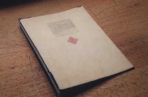
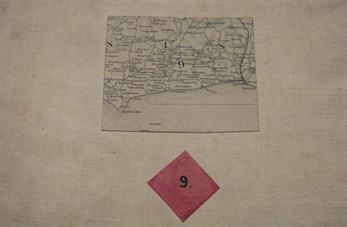
Sectioned for folding, 4x2 pieces, mounted, blue ribbon binding crudely sewn on - tatty 150 years later, folded up from bottom with map face inside, then zigzag across. The map size is:-
wxh, sheet = 96.5x64cm
wxh, folded = 242x323mmThe outside ends are marked by pink diamonds, 1 inch square pink paper on the diagonal, pasted on the reverse of outer sections. One diamond labelled with the sheet number, eg:-
9.This end section has a location map pasted on it to show the map coverage, snipped out of the 10 miles to 1 inch index map. There is also a tab pasted on to stand up at top centre, with the sheet number, now crumpled.
HMCMS:FA1998.91 -- sheet 10
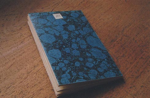
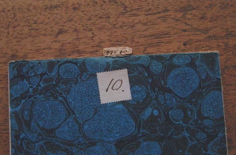
Sectioned for folding, 7x3 pieces, mounted, folded up from bottom with map face inside, then zigzag across. The end sections have blue marbled card pasted on for protection. The map size is:-
wxh, sheet = 96.5x65.5cm
wxh, folded = 138x220mmThere is a tab pasted on to stand up at top centre, with the sheet number:-
10.This is crumpled.
HMCMS:FA2003.1.15 -- sheet 15
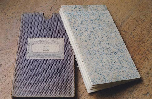
Sectioned for folding, 7x3 pieces, mounted, folded up from bottom with map face inside, then zigzag across. The end sections have lightly marbled end papers pasted on for protection, which continue a short way round the fold. The map is presented in a slip case which has thumb cutouts for getting the map out, and dirty marks on the map to match. The map size is:-
wxh, sheet = 86.5x67cm
wxh, folded = 125x226mmPasted on the outer section, visible at the thumb cutout, is a location map, a tiny rectangle about 14x12mm, scale about 40 or 50 miles to 1 inch, with the sheet number:-
15The stiff brown slip case is covered in brown textile and embossed in a diagonal pattern of small squares, size:-
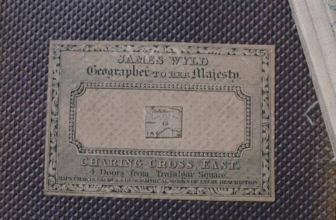
wxh, slip case = 134x232mmThe slip case has a paper label, printed in a scroll cartouche:-
JAMES WYLD Geographer / TO HER / Majesty. / CHARING CROSS, EAST. / 4 Doors from Trafalgar Square. / MAPS, CHARTS, GLOBES & GEOGRAPHICAL WORKS OF EVERY DESCRIPTION.A central cartouche with a picture frame border has pasted on it the same minute location map with the sheet number.
HMCMS:FA2001.6 -- sheet 6
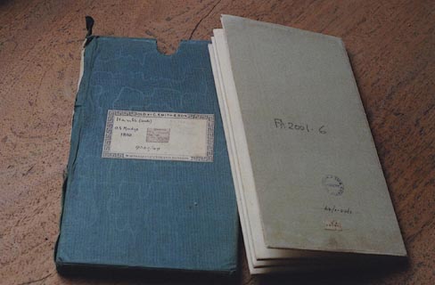
Sectioned for folding, 7x3 pieces, mounted, folded up from bottom with map face inside, then zigzag across. The end sections have pale buff end papers pasted on for protection. The map is presented in a slip case which has thumb cutouts for getting the map out, and dirty marks on the map to match. The map size is:-
wxh, sheet = 84x66cm
wxh, folded = 126x222mmPasted on the outer section is a location map, a tiny rectangle about 14x8mm, scale about 40 or 50 miles to 1 inch, with the sheet number:-
12The card slip case is covered with dark green moire silk, size:-
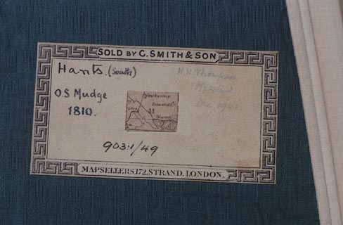
wxh, slip case = 133x230mmPasted on the slip case is a paper label with a greek key border, printed in top and bottom borders:-
SOLD BY C. SMITH & SON / MAPSELLERS. 172, STRAND, LONDON.A tiny location map is pasted in the centre of the label, and various owners have added their own remarks:-
Hants (N.E.) / O.S. Mudge. / 1817. / 1 Mile to 1 Inch
Medstead
H. W. THompson / Medsted / Dec. 1941
903.1/48
In every instance the map has to be completely unfolded to be read.


