
|
Catalogue of Map Collection
GOS -- WOC:
Identity number order
 |
FA2001 -- FA2004 |
 |
bottom of page |
|
|
A thumbnail image on the right will enlarge, then return here.
The left link will take you to the Map Collection record page, and if (Map Group) is shown, will link to other Hampshire resources.
If you want to return to your place here, use your back browser button.
|
|
Identity number
(Map Group)
|
|
|
 |
|
GOS1976.23

|
Map, showing wild grounds? Alverstoke, Gosport, Hampshire,
published 1939.
|
|
|
|
GOS1976.59.4
|
Map, cloth bound, Surrey, published by Bacon, 1910.
|
|
|
|
GOS1976.60
|
Map, Portsmouth, Hampshire, captured from a german soldier in
Netherlands, made in Germany, about 1939.
|
|
|
|
GOS1977.120
|
Map, Drinker's Guide to Gosport, 60 ale houses in the centre
of Gosport, Hampshire, 1850.
|
|
|
|
GOS1977.149
|
Map, linen backed, in black carrying case, Tower of London,
London.
|
|
|
|
GOS1979.19
|
Map, and local advertisements, with a calendar, made 1925.
|
|
|
|
GOS1979.38
|
Map, bombing map, showing the south coast from Bracklesham,
Isle of Wight, Hampshire, to Lyme Bay, Dorset, made in Germany,
1941.
|
|
|
|
GOS1979.38.1
|
Map, bombing map, Southampton Docks, aircraft construction
etc, Southampton, Hampshire, made in Germany, 1941.
|
|
|
|
GOS1979.38.2
|
Map, bombing map, Royal Naval Dockyard, Portsmouth, and part
of Priddy's Hard, Gosport, Fort Nelson, HMS Dolphin, etc,
Hampshire, made in Germany, 1941.
|
|
|
|
GOS1981.8.1
|
Map, book, plans and sections, Portsmouth Corporation
Tramways, Portsmouth, Hampshire, November 1887.
|
|
|
|
GOS1981.8.2
|
Map, book, plans and sections, Plymouth, Stonehouse and
Devonport Tramways.
|
|
|
|
GOS1981.8.3
|
Map, book, additional provisions, plans and sections, Gosport,
Fareham and Cosham Tramways, Hampshire, 1903.
|
|
|
|
GOS1981.8.4
|
Map, book, extensions plans and sections, tramways in Gosport,
Hampshire, 1880.
|
|
|
|
GOS1981.8.5
|
Map, book, tramways, plans and sections, Gosport, Fareham,
Portchester and Cosham tramways, 1903.
|
|
|
|
GOS1981.8.56
|
Map, 1 to 2500, sheet SU5704NE, Hoeford area, Fareham,
Hampshire, published by the Ordnance Survey, 1964.
|
|
|
|
GOS1981.17
|
Map, England and Wales, 12 maps, 1/4 inch to 1 mile, in
leather carrying case, made 1929.
|
|
|
|
GOS1982.12
|
Map, bombing map, 6 inches to 1 mile, prime targets marked,
made in Germany, during World War II, about 1939.
|
|
|
|
GOS1982.64
|
Map, Gosport and part of Portsmouth and Southsea, Hampshire,
about 1897.
|
|
|
|
GOS1982.77.64
|
Map, scale 25 inches to 1 mile, sheet SU 6000 SE, part of
Gosport, Hampshire, published by Ordnance Survey, 1950.
|
|
|
|
GOS1982.86
|
Map, bus route, folded to fit pocket, London, 1934.
|
|
|
|
GOS1983.79.34
|
Map, route map of road services, Gosport area, Hampshire?
1981.
|
|
|
|
GOS1983.79.35
|
Map, route map of road services, Gosport area, Hampshire?
1981.
|
|
|
|
HCMS1974.574
|
Map, hand coloured pictorial map of Sebastopol and the Crimea,
from the home of Miss M E Tasker, Brookside, Abbotts Ann,
Hampshire, published by Rock Bros and Payne, 11 Walbrook, London,
1854.
|
|
|
|
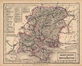
HCMS1975.178
|
Map, Barnett's Official Street Plan of Basingstoke, Hampshire,
scale about 6 inches to 1 mile, published by G I Barnett and Son,
Chadwell Heath, Essex, 1950s-60s.
|
|
|
|
KD1989.1.12B1
|
Map, traced from photograph of Tithe map with notes from map
and Tithe book, Hampshire, 9.1963.
|
|
|
|
KD1989.1.12B2
|
Map, Tithe map of Clatford, copy, Hampshire, 5 July 1821.
|
|
|
|
KD1989.1.13B
|
Map, tracing of Tithe map of Clatford, Hampshire, 5 July
1821.
|
|
|
|
KD1992.289
(Parker 1777)
|
Map, uncoloured engraving, Plan of the intended Navigable
Canal from Basingstoke to the River Wey, scale roughly 1 mile to
1 inch, made for the canal prospectus, engraved by William Faden,
Charing Cross, London, surveyed by Joseph Parker, about 1777.
|
|
|
|
KD1992.292
(Giles 1838)
|
Map, 8 lithograph sheets, parts in Hampshire of a planned
railway, London and Salisbury Junction Railway, from Kings
Worthy, Hampshire to Salisbury, Wiltshire, scale 4 inches to 1
mile, by Francis Giles, civil engineer, engraved by J
Netherclift, 23 King William Street, Strand, London, 1838.
|
|
|
|
KD1992.293
|
Map, photocopy, Defences in the Christchurch Area in World War
II, Dorset, 1939-45, drawn by M A Hodges, 1977.
|
|
|
|
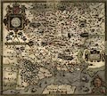
KD1996.1
(Saxton 1575)
|
Map, hand coloured copper plate engraving, Southamtoniae, ie
Hampshire, scale about 4 miles to 1 inch, engraved by Leonard
Terwoort, Antwerp, Netherlands, published by Christopher Saxton,
map maker, London? about 1575.
|
|
|
|
KD1996.2
(Norden 1607)
|
Map, uncoloured copper plate engraving, Hamshire olim Pars
Belgarum ie Hampshire, with part of the Isle of Wight, scale
about 6 miles to 1 inch, by John Norden, about 1595, engraved by
William Hole, published in William Camden's Britannia, 6th Latin
edition, 1607.
|
|
|
|
KD1996.3
(Keer 1605)
|
Map, uncoloured engraving, Southampton, ie Hampshire, scale
about 16.5 statute miles to 1 inch, by Pieter van den Keere, 1605
and 1620, published 1666.
|
|
|
|
KD1996.5
(Cundee 1815)
|
Map, Hampshire, scale about 6 miles to 1 inch, included in the
New British Traveller, by Dugdale, 1819, engraved by Neele,
Strand, London, published by J and J Cundee, Albion Press,
London, 1815.
|
|
|
|
KD1996.6
(Taylor 1759)
|
Reproduction map, Map of Hampshire, with the Isle of Wight, 6
sheets, by Isaac Taylor, 1759, scale about 1 mile to 1 inch, but
published at about 3/4 size by Hampshire Field Club and
Archaeological Society, 1933.
|
|
|
|
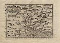
KD1996.7
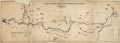
(Ogilby 1675)
|
Strip map, uncoloured engraving, road map of part of The Road
from London to Southampton, Hampshire, from the road book,
Britannia, published by John Ogilby, White Friars, London,
1675.
|
|
|
|
KD1996.8
|
Map, geological map, Farnham area, Surrey, scale 3 inches to 1
mile, 1930s-40s?
|
|
|
|
KD1996.9
|
Map, mesolithic sites in Farnham area, Surrey, scale 3 inches
to 1 mile, drawn by W F Rankin, early 20th century?
|
|
|
|
KD1996.10
|
Map, neolithic sites in Farnham area, Surrey, scale 3 inches
to 1 mile, drawn by W F Rankin, early 20th century?
|
|
|
|
KD1996.11
|
Map, bronze age sites in Farnham area, Surrey, scale 3 inches
to 1 mile, drawn by W F Rankin, early 20th century?
|
|
|
|
KD1996.12
|
Map, iron age sites in Farnham area, Surrey, scale 3 inches to
1 mile, drawn by W F Rankin, early 20th century?
|
|
|
|
KD1996.13
|
Map, roman sites in Farnham area, Surrey, scale 3 inches to 1
mile, drawn by W F Rankin, early 20th century?
|
|
|
|
KD1996.14
(Hall 1833)
|
Map, hand coloured engraving, Hampshire or Southampton, and
the Isle of Wight, scale about 8 miles to 1 inch, engraved by
Sidney Hall, 1830s, published by Chapman and Hall, Piccadilly,
London, about 1865.
|
|
|
|
KD1996.15
(Blome 1673)
|
Map, hand coloured etching, A Mapp of Hantshire, ie Hampshire,
with part of the Isle of Wight, scale about 4 miles to 1 inch, by
Richard Blome, about 1673.
|
|
|
|
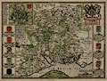
KD1996.16
(Speed 1611)
|
Map, hand coloured copper plate engraving, Hantshire described
and divided, Hampshire with part of the Isle of Wight, scale
about 4 miles to 1 inch, and a town plan of Winchester, by John
Speed, engraved by Jodocus Hondius, about 1611.
|
|
|
|
KD1996.17
(Bill 1626)
|
Map, uncoloured engraving, Hant Shire, ie Hampshire, scale
about 16.5 miles to 1 inch, by John Bill, published in an
abridged edition of Britannia, by William Camden, about 1626.
|
|
|
|
KD1996.18
|
Map, Selborne area, Hampshire, sheet Hants XLIII NE, scale 6
inches to 1 mile, published by the Ordnance Survey, 1910, hand
painted to show local geology.
|
|
|
|
KD1996.19
(Cary 1790)
|
Map, hand coloured copper plate engraving, Hampshire, with
Isle of Wight, scale about 14 miles to 1 inch, by John Cary, 181
Strand, London 1790? published 1814.
|
|
|
|
KD1996.21
(Greenwood 1826)
|
Map, uncoloured steel plate engravings, Map of the County of
Southampton, ie Hampshire, with the Isle of Wight, scale about 1
miles to 1 inch, by C and J Greenwood, and Nathaniel L Kentish,
published by Greenwood, Pringle and Co, Regent Street, Pall Mall,
London, 1826.
|
|
|
|
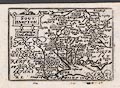
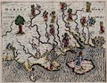
KD1996.23
(Drayton 1612)
|
Map, hand coloured copper plate engraving, fantastical map of
Dorset, Hampshire and the Isle of Wight, published in
Poly-Olbion, by Michael Drayton, poet, engraved by William Hole,
about 1612.
|
|
|
|
KD1996.25
|
Map, watercolour painting copy, A True Ground Plot of Weyhill
Faire, Penton Grafton, Hampshire, scale about 38ins to 1 mile,
originally drawn 1683.
|
|
|
|
P1985.60
|
photograph, manuscript estate plan, Mapp of New Park Farm, in
the estate of Thomas Knight, Chawton, Hampshire, 1741, by Edward
Randall snr and Edward Randall jnr, reproduced scale about 1 to
6000, about 11 ins to 1 mile, photographed about 1985.
|
|
|
|
PH1998.1.233
|
Map, The Crimea, Russia, including Sevastapol town and
harbour, published during the Crimean War, by James Wyld, Charing
Cross, London, 1855.
|
|
|
|
PH1998.1.234
|
Map, Plan of Portsea, showing the fortifications of Portsea,
Gosport Lines and Outforts, Portsmouth area, Hampshire, 1773.
|
|
|
|
PH1998.1.235
|
Map, Map of Gosport, Hampshire, with Priddy's Hard and Royal
Clarence Yard, by Lt J Lynn RE, 1829.
|
|
|
|
R15
(Kitchin 1751 small)
|
Map, Hampshire, hand coloured copper plate engraving,
Hampshire and Isle of Wight, scale about 11 miles to 1 inch,
published in the Small English Atlas, by Thomas Kitchin, London,
about 1751.
|
|
|
|
R60
|
Map, scale 1/2 inch to 1 mile, Aldershot and District War
Office Series, published by Ordnance Survey.
|
|
|
|
R274
(Saxton 1575)
|
Reproduction map, Hampshire, published by Christopher Saxton,
1575, published 20th century?
|
|
|
|
R417
|
Map, County Series map, scale 6 inches to 1 mile, Aldershot
area, Rushmoor, Hampshire, published by the Ordnance Survey,
1909-12.
|
|
|
|
R418
|
Map, watercolour tinted, Aldershot, Rushmoor, Hampshire,
1950s.
|
|
|
|
R567
|
Map, paper on linen, rough plan of temporary barracks,
Aldershot Common, scale 4 inches to 1 mile, made by the Ordnance
Survey? 1855.
|
|
|
|
R701
|
Map, proposals for tramways for Aldershot and Farnborough
area, Rushmoor, Hampshire, January 1958.
|
|
|
|
R712
(Wright 1791)
|
Map, plan of the Basingstoke Canal, canal from Basingstoke,
Hampshire, to the River Wey, Weybridge, Surrey, published by
William Wright, engineer, Frimley, Surrey, 1 November 1791.
|
|
|
|
R1991.151
(Dispatch 1863)
|
Road map, Hampshire, scale about 3 miles to 1 inch, by G W
Bacon and Co, Bacon's Geographical Establishment, Norwich Street,
London, late 19th century.
|
|
|
|
R1991.218.95
|
Map, Military Three Inch Scale Map of Aldershot and District,
scale about 3 inches to 1 mile, published by Gale and Polden,
Wellington Works, Aldershot, Rushmoor, Hampshire, 1910s?
|
|
|
|
R1991.218.97
|
Map, Map of the Aldershot Command, British Army areas,
Hampshire and Surrey, scale 1 inch to 1 mile, by Ordnance Survey,
published by the War Office, 1931.
|
|
|
|
R1991.218.98
|
Map, Map of the Aldershot Command, British Army areas,
Hampshire and Surrey, scale 1 inch to 1 mile, by Ordnance Survey,
published by the War Office, 1934.
|
|
|
|
R1991.218.100
|
Map, Surrey Commons Training Areas, British Army, in Surrey
and Hampshire, scale 2.5 inches to 1 mile, published by Defence
Survey, Ministry of Defence, 1972.
|
|
|
|
R1991.218.101
|
Map, Ash Ranges, Surrey, with detail for the Harvester Trophy
Relay race, scale about 4 inches to 1 mile, by Master Maps,
Spring Lane, Farnham, Surrey, 1981.
|
|
|
|
R1991.218.102
|
Map, Surrey Commons, British Army training areas in Surrey and
Hampshire, scale 2.5 inches to 1 mile, published by Military
Survey, Ministry of Defence, 1983.
|
|
|
|
R1991.218.103
|
Map, Aldershot Military Lands and Training Areas, British Army
in Hampshire and Surrey, scale 2.5 inches to 1 mile, published by
Military Survey, Ministry of Defence, 1986.
|
|
|
|
R1991.218.111
|
Map, England, South East and London, scale 4 miles to 1 inch,
by the Ordnance Survey, published for Defence Survey, 1958.
|
|
|
|
R1991.218.113
|
Road map, and table of distances, Route Planning Map, North,
scale about 10 miles to 1 inch, published by the Ordnance Survey,
Southampton, Hampshire, 1969.
|
|
|
|
R1991.218.114
|
Road map, and table of distances, Route Planning Map, South,
scale about 10 miles to 1 inch, published by the Ordnance Survey,
Southampton, Hampshire, 1969.
|
|
|
|
R1991.218.115
|
Map, Country round Aldershot, Hampshire and Surrey etc, scale
2 miles to 1 inch, published by the Ordnance Survey, Southampton,
Hampshire, 1909.
|
|
|
|
R1993.20
|
Map, bus route map for Aldershot and District Traction Co,
Aldershot area, Rushmoor, Hampshire, about 1920.
|
|
|
|
R1993.22
|
Map, copy of the inclosure map for Cove, Farnborough,
Rushmoor, Hampshire, made by David Cleeve, 2 August 1859.
|
|
|
|
R1994.11
|
Bus map, showing the main routes of the Aldershot and District
Traction Co, Aldershot and Farnborough area, Rushmoor, out to the
rest of Hampshire, scale about 4 miles to 1 inch, drawn by
Searle, Reading, Berkshire, 1968.
|
|
|
|
SH1993.602
|
Map, Map of Hampshire, made by Boro and Counties Commercial
Advertising Company, Birmingham, 1890-1910?
|
|
|
|
SH1993.603
|
Map, Ordnance Survey England and South West, quarter inch
scale, sheet 10, made by The Ordnance Survey Office, Southampton,
Hampshire, 1946.
|
|
|
|
SH1993.604
|
Map, Geographers 4 sheet Map of London, made by Alexander Goss
and the Geographers' Map Company Ltd, High Holborn, London.
|
|
|
|
SH1993.606
|
Map, Barnett's Rural District Map Basingstoke, costing 15p,
made by G I Barnett, Barking, Essex, 1971-1979?
|
|
|
|
SH1993.607
|
Map, Barnett's Rural District Map Basingstoke, costing three
shillings, made by G I Barnett, Barking, Essex, 1960-1970?
|
|
|
|
SH1993.853
|
Map, The Cyclist Pocket Touring Maps of Britain, cased set of
seven double sided maps, printed by W and A K Johnston, Ltd,
Edinburgh and London, late 1939.
|
|
|
|
SH1995.5.5
|
road map, Hampshire, with the Isle of Wight, scale about 1 to
190000, 3 miles to 1 inch, published by Geographia, 167 Fleet
Street, London
|
|
|
|
SH1995.13.5
|
Railway map, Underground Railway Map, published by London
Transport, 55 Broadway, Victoria, London, 1937.
|
|
|
|
SH1999.621
|
Railway map, Diagram Map of the Great Western Railway, scale
about 13 miles to 1 inch, framed for the wall of a carriage,
issued by the GWR, about 1920s?
|
|
|
|
WOC4458
|
Map, New Allotments of Land in the Manor of Dummer, pen and
ink drawing, scale about 8 inches to 1 mile, Dummer, Dummer with
Kempshot, Hampshire, made by Robert Scullard, 1743.
|
|
|
|
WOC4459
(Speed 1611)
|
Map, copper plate engraving, Hantshire, ie Hampshire, scale
about 4 miles to 1 inch, by John Speed, published by Sudbury and
Humble, Popeshead Alley, London, about 1611.
|
|
|
|
WOC4716
(Dugdale 1835)
|
Map, uncoloured engraving, Hampshire, with the Isle of Wight,
scale about 8 miles to 1 inch, drawn by J Archer, Pentonville,
London, published in England and Wales Delineated by T Dugdale,
about 1835, published 1840s?
|
|
|
|
WOC5598.4
(Dawson 1832)
|
Map, copy of hand coloured lithograph, Basingstoke, Hampshire,
nominal scale 1 mile to 1 inch, indicating proposed changes in
municipal boundaries, by Lt Robert K Dawson RE, 1835, copied
1937.
|
|
|
|
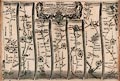
WOC5927
(Railway Chronicle 1846)
|
Railway map, guide book with strip maps, scale about 1 inch to
1 mile, a Travelling Chart or Iron Road Book, for the line from
Nine Elms, London to Southampton, Hampshire, published by the
Railway Chronicle, 14 Wellington Street North, Strand, London,
about 1846.
|

|
|
|
|
 |
top of page |
 |
PRIVATE |
|