
|
Maps from Private Collections
 |
GOS -- WOC |
 |
bottom of page |
|
|
A thumbnail image on the right will enlarge, then return here.
The left link will take you to the Map Collection record page, and if (Map Group) is shown, will link to other Hampshire resources.
If you want to return to your place here, use your back browser button.
|
|
Identity number
(Map Group)
|
|
|
 |
|
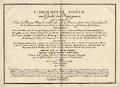
private collection (1)
(Unknown 1700s)

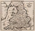
|
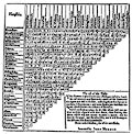
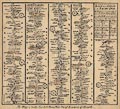
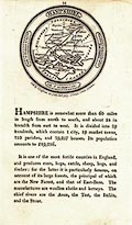
Map, uncoloured engraving, Map of a Country Exemplified, a
fictional map for teaching, showing map features, 18th
century.
|
|
|
|
private collection (2)
(Chambers 1890s)
|
Map, colour printed engraving, England and Wales, by W and R
Chambers, Edinburgh, Lothian, 1890s.
|
|
|
|
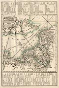
private collection (3)
(Bowles 1773)
|
Map, partly coloured engraving, New Travelling Map of England
and Wales, scale about 25 miles to 1 inch, by Carington Bowles,
69 St Paul's Church Yard, London, 1773.
|
|
|
|
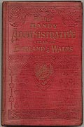
private collection (4)
(Philip 1908)
|
Atlas, the Handy Administrative Atlas of England and Wales,
published by George Philip and Son, 32 Fleet Street, London,
about 1908.
|
|
|
|
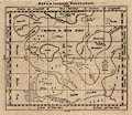
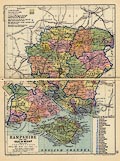
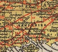
private collection (4_19)
(Philip 1908)
|
Map, engraving and colour lithograph? Hampshire and the Isle
of Wight, scale about 8.5 miles to 1 inch, published in the Handy
Administrative Atlas of England and Wales, by George Philip and
Son, 32 Fleet Street, London, about 1908.
|
|
|
|
private collection (5)
(Philip 1886)
|
Atlas, Handy Atlas of the Counties, England, by George Philip
and Son, 32 Fleet Street, London, new edition, 1886.
|
|
|
|
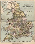
private collection (5_01)
(Philip 1886)
|
Railway map, engraving and colour lithograph? Railway Map of
England and Wales, scale about 56 miles to 1 inch, published in
the Handy Atlas of the Counties, England, by George Philip and
Son, 32 Fleet Street, London, 1886.
|
|
|
|
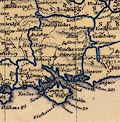
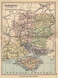
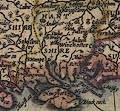
private collection (5_14)
(Philip 1886)
|
Map, engraving and colour lithograph? Hampshire, including the
Isle of Wight, scale about 8.5 miles to 1 inch, published in the
Handy Atlas of the Counties, England, by George Philip and Son,
32 Fleet Street, London, 1886.
|
|
|
|
private collection (6)
(Gall and Inglis 1900s)
|
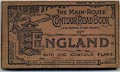
Road book, Main Route Contour Road Book of England, published
by Gall and Inglis, 12 Newington Road, Edinburgh, Lothian,
1900s.
|
|
|
|
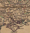
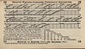
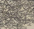
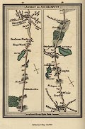
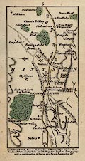
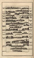
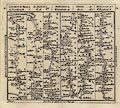
private collection (6_12)
(Gall and Inglis 1900s)
|
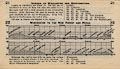
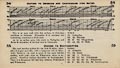
Contour diagram, with itinerary and table of distances,
Brighton to Southampton, in the Main Route Contour Road Book of
England, published by Gall and Inglis, 12 Newington Road,
Edinburgh, Lothian, 1900s.
|
|
|
|
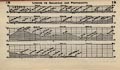
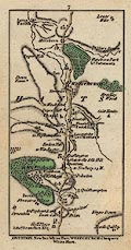
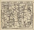
private collection (6_18)
(Gall and Inglis 1900s)
|
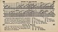
Contour diagram, with itinerary and table of distances, London
to Portsmouth, in the Main Route Contour Road Book of England,
published by Gall and Inglis, 12 Newington Road, Edinburgh,
Lothian, 1900s.
|
|
|
|
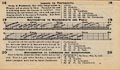
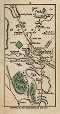
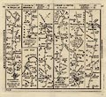
private collection (6_19)
(Gall and Inglis 1900s)
|
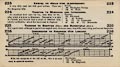
Contour diagram, with itinerary and table of distances,
Southampton to Poole, in the Main Route Contour Road Book of
England, published by Gall and Inglis, 12 Newington Road,
Edinburgh, Lothian, 1900s.
|
|
|
|
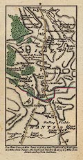
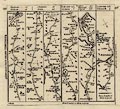
private collection (6_20)
(Gall and Inglis 1900s)
|
Contour diagram, with itinerary and table of distances,
Southampton to Christchurch, in the Main Route Contour Road Book
of England, published by Gall and Inglis, 12 Newington Road,
Edinburgh, Lothian, 1900s.
|
|
|
|
private collection (6_21)
(Gall and Inglis 1900s)
|
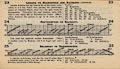
Contour diagram, with itinerary and table of distances, London
to Winchester and Southampton, in the Main Route Contour Road
Book of England, published by Gall and Inglis, 12 Newington Road,
Edinburgh, Lothian, 1900s.
|
|
|
|
private collection (6_22)
(Gall and Inglis 1900s)
|
Contour diagram, with itinerary and table of distances,
Winchester to Poole, in the Main Route Contour Road Book of
England, published by Gall and Inglis, 12 Newington Road,
Edinburgh, Lothian, 1900s.
|
|
|
|
private collection (6_23)
(Gall and Inglis 1900s)
|
Contour diagram, with itinerary and table of distances, London
to Salisbury, in the Main Route Contour Road Book of England,
published by Gall and Inglis, 12 Newington Road, Edinburgh,
Lothian, 1900s.
|
|
|
|
private collection (6_24)
(Gall and Inglis 1900s)
|
Contour diagram, with itinerary and table of distances,
Southampton to Salisbury, in the Main Route Contour Road Book of
England, published by Gall and Inglis, 12 Newington Road,
Edinburgh, Lothian, 1900s.
|
|
|
|
private collection (6_25)
(Gall and Inglis 1900s)
|
Contour diagram, with itinerary and table of distances,
Salisbury to Christchurch, in the Main Route Contour Road Book of
England, published by Gall and Inglis, 12 Newington Road,
Edinburgh, Lothian, 1900s.
|
|
|
|
private collection (6_32)
(Gall and Inglis 1900s)
|
Contour diagram, with itinerary and table of distances, London
to Aldershot, in the Main Route Contour Road Book of England,
published by Gall and Inglis, 12 Newington Road, Edinburgh,
Lothian, 1900s.
|
|
|
|
private collection (6_55)
(Gall and Inglis 1900s)
|
Contour diagram, with itinerary and table of distances, Oxford
to Southampton, in the Main Route Contour Road Book of England,
published by Gall and Inglis, 12 Newington Road, Edinburgh,
Lothian, 1900s.
|
|
|
|
private collection (6_57)
(Gall and Inglis 1900s)
|
Contour diagram, with itinerary and table of distances, Oxford
to Reading, in the Main Route Contour Road Book of England,
published by Gall and Inglis, 12 Newington Road, Edinburgh,
Lothian, 1900s.
|
|
|
|
private collection (6_226)
(Gall and Inglis 1900s)
|
Contour diagram, with itinerary and table of distances,
Dorchester to Ringwood, in the Main Route Contour Road Book of
England, published by Gall and Inglis, 12 Newington Road,
Edinburgh, Lothian, 1900s.
|
|
|
|
private collection (6_EW)
(Gall and Inglis 1900s)
|
Road map, England and Wales, scale about 33 miles to 1 inch,
in the Main Route Contour Road Book of England, published by Gall
and Inglis, 12 Newington Road, Edinburgh, Lothian, 1900s.
|
|
|
|
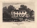
private collection (7)
(Cobbett 1830)
|
Print, engraving, birthplace of William Cobbett, Farnham,
Surrey, published in Dugdales England and Wales Delineated, mid
19th century.
|
|
|
|
private collection (8)
(Speed 1611)
|
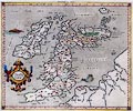
Map, coloured engraving, Kingdome of Great Britaine and
Ireland, scale about 36 miles to 1 inch, by John Speed, about
1610-11, published by Thomas Bassett, Fleet Street and Richard
Chiswell, St Paul's Churchyard, London, 1676.
|
|
|
|
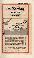
private collection (9)
(Burrow 1920s)
|
Road book, strip maps and descriptive text, On the Road, the
Dunlop Pictorial Road Plans, vol.2, published for Dunlop by E J
Burrow and Co, Cheltenham, Gloucestershire, 2nd edn 1920s.
|
|
|
|
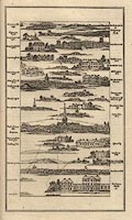
private collection (9_33)
(Burrow 1920s)
|
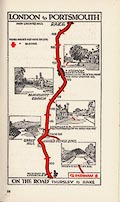
Strip map, colour printed road map p.33, London to Portsmouth,
scale about 1.5 to 2.5 miles to 1 inch, published for Dunlop in
On the Road vol.2, by E J Burrow, Cheltenham, Gloucestershire,
1920s?
|
|
|
|
private collection (9_35)
(Burrow 1920s)
|
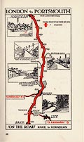
Strip map, colour printed road map p.35, London to Portsmouth,
scale about 1.5 to 2.5 miles to 1 inch, published for Dunlop in
On the Road vol.2, by E J Burrow, Cheltenham, Gloucestershire,
1920s?
|
|
|
|
private collection (9_37)
(Burrow 1920s)
|
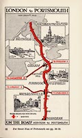
Strip map, colour printed road map p.37, London to Portsmouth,
scale about 1.5 to 2.5 miles to 1 inch, published for Dunlop in
On the Road vol.2, by E J Burrow, Cheltenham, Gloucestershire,
1920s?
|
|
|
|
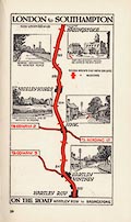
private collection (9_57)
(Burrow 1920s)
|
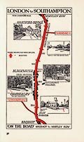
Strip map, colour printed road map p.57, London to
Southampton, scale about 1.5 to 2.5 miles to 1 inch, published
for Dunlop in On the Road vol.2, by E J Burrow, Cheltenham,
Gloucestershire, 1920s?
|
|
|
|
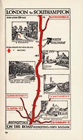
private collection (9_59)
(Burrow 1920s)
|
Strip map, colour printed road map p.59, London to
Southampton, scale about 1.5 to 2.5 miles to 1 inch, published
for Dunlop in On the Road vol.2, by E J Burrow, Cheltenham,
Gloucestershire, 1920s?
|
|
|
|
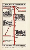
private collection (9_61)
(Burrow 1920s)
|
Strip map, colour printed road map p.61, London to
Southampton, scale about 1.5 to 2.5 miles to 1 inch, published
for Dunlop in On the Road vol.2, by E J Burrow, Cheltenham,
Gloucestershire, 1920s?
|
|
|
|
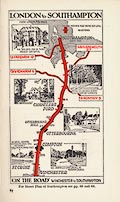
private collection (9_63)
(Burrow 1920s)
|
Strip map, colour printed road map p.63, London to
Southampton, scale about 1.5 to 2.5 miles to 1 inch, published
for Dunlop in On the Road vol.2, by E J Burrow, Cheltenham,
Gloucestershire, 1920s?
|
|
|
|
private collection (9_67)
(Burrow 1920s)
|
Strip map, colour printed road map p.67, London to
Southampton, scale about 1.5 to 2.5 miles to 1 inch, published
for Dunlop in On the Road vol.2, by E J Burrow, Cheltenham,
Gloucestershire, 1920s?
|
|
|
|
private collection (9_71)
(Burrow 1920s)
|
Strip map, colour printed road map p.71, London to
Bournemouth, scale about 1.5 to 2.5 miles to 1 inch, published
for Dunlop in On the Road vol.2, by E J Burrow, Cheltenham,
Gloucestershire, 1920s?
|
|
|
|
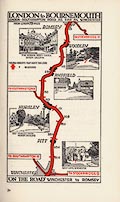
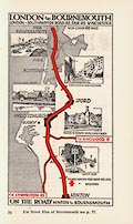
private collection (9_73)
(Burrow 1920s)
|
Strip map, colour printed road map p.73, London to
Bournemouth, scale about 1.5 to 2.5 miles to 1 inch, published
for Dunlop in On the Road vol.2, by E J Burrow, Cheltenham,
Gloucestershire, 1920s?
|
|
|
|
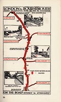
private collection (9_74)
(Burrow 1920s)
|
Strip map, colour printed road map p.74, London to
Bournemouth, scale about 1.5 to 2.5 miles to 1 inch, published
for Dunlop in On the Road vol.2, by E J Burrow, Cheltenham,
Gloucestershire, 1920s?
|
|
|
|
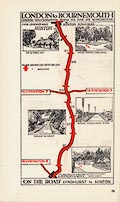
private collection (9_75)
(Burrow 1920s)
|
Strip map, colour printed road map p.75, London to
Bournemouth, scale about 1.5 to 2.5 miles to 1 inch, published
for Dunlop in On the Road vol.2, by E J Burrow, Cheltenham,
Gloucestershire, 1920s?
|
|
|
|
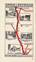
private collection (9_78)
(Burrow 1920s)
|
Strip map, colour printed road map p.78, London to Weymouth,
scale about 1.5 to 2.5 miles to 1 inch, published for Dunlop in
On the Road vol.2, by E J Burrow, Cheltenham, Gloucestershire,
1920s?
|
|
|
|
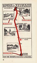
private collection (9_79)
(Burrow 1920s)
|
Strip map, colour printed road map p.79, London to Weymouth,
scale about 1.5 to 2.5 miles to 1 inch, published for Dunlop in
On the Road vol.2, by E J Burrow, Cheltenham, Gloucestershire,
1920s?
|
|
|
|
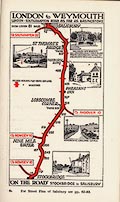
private collection (9_81)
(Burrow 1920s)
|
Strip map, colour printed road map p.81, London to Weymouth,
scale about 1.5 to 2.5 miles to 1 inch, published for Dunlop in
On the Road vol.2, by E J Burrow, Cheltenham, Gloucestershire,
1920s?
|
|
|
|
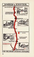
private collection (9_95)
(Burrow 1920s)
|
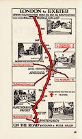
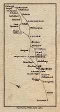
Strip map, colour printed road map p.95, London to Exeter,
scale about 1.5 to 2.5 miles to 1 inch, published for Dunlop in
On the Road vol.2, by E J Burrow, Cheltenham, Gloucestershire,
1920s?
|
|
|
|
private collection (9_96)
(Burrow 1920s)
|
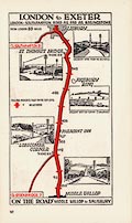
Strip map, colour printed road map p.96, London to Exeter,
scale about 1.5 to 2.5 miles to 1 inch, published for Dunlop in
On the Road vol.2, by E J Burrow, Cheltenham, Gloucestershire,
1920s?
|
|
|
|
private collection (9_97)
(Burrow 1920s)
|
Strip map, colour printed road map p.97, London to Exeter,
scale about 1.5 to 2.5 miles to 1 inch, published for Dunlop in
On the Road vol.2, by E J Burrow, Cheltenham, Gloucestershire,
1920s?
|
|
|
|
private collection (10)
(Morden 1695)
|
Map, hand coloured engraving, England, including Wales, scale
about 27 miles to 1 inch, by Robert Morden, published by Abel
Swale Awnsham and John Churchil, London, about 1695.
|
|
|
|
private collection (11)
(Fullarton 1856)
|
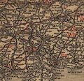
Map, partly coloured engraving, Plan of Portsmouth, Portsea,
Spithead and Vicinity, scale about 2.5 miles to 1 inch, from the
Imperial Gazetteer, by Archibald Fullarton and Co, London and
Edinburgh, Lothian, about 1856.
|
|
|
|
private collection (12)
(Cary 1801)
|
Map, hand coloured engraving, A New Map of Hampshire, scale
about 2.5 miles to 1 inch, by John Cary, London, 1801.
|
|
|
|
private collection (13)
(Cole and Roper 1810)
|
Map, hand coloured engraving, England and Wales, index sheet
to the British Atlas, scale about 43 miles to 1 inch, engraved by
J Cole under the direction of E W Brayley, published by Vernor,
Hood, and Sharpe, Poultry, London, 1809.
|
|
|
|
private collection (14)
(Bowles 1782)
|
Map, uncoloured engraving, General View of the Roads, scale
roughly 80 miles to 1 inch, for Bowles's Post Chaise Companion,
by Carington Bowles, London, 1782.
|
|
|
|
private collection (15)
(Ogilby 1675)
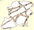
|
Road map, printout from an image file, Hampshire Road Map
1675, strip maps by John Ogilby combined on an outline of the
county, scale about 1 inch to 1 mile, by Jean Norgate, 1999.
|
|
|
|
private collection (16)
(Norden 1625)
|
Guide book, England, an Intended Guyde for English Travailers,
by John Norden, London, 1625.
|
|
|
|
private collection (17)
(Ptolemy 1578)
|
Map, hand coloured engraving, Europe Map 1, Ptolemy map of
roman Britain, by Gerard Mercator, 1578.
|
|
|
|
private collection (18)
(Bazaar 1890)
|
Road map, The Tourist Route Map of England and Wales,
published by the Bazaar Exchange and Mart Office, 170 Strand,
London, about 1890.
|
|
|
|
private collection (19)
(Musgrave 1717)
|
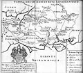
Map, uncoloured engraving, Belgium, the land of the Belgae,
southern England, scale about 22.5 miles to 1 inch, by George
Musgrave, 1717, drawn for his brother's book, Antiquitates
Britanno-Romanae, by William Musgrave, published London,
1719.
|
|
|
|
private collection (20)
(Fothergill 1900s)
|
Road map, Finger Post Strip Map, London to Exeter, by Gerald
Fothergill, published by George Philip and Son, 32 Fleet Street,
London, 1900s?
|
|
|
|
private collection (21)
(Fothergill 1900s)
|
Road map, Finger Post Guides to Road Junctions, 12 Routes from
London, by Gerald Fothergill, published by George Philip and Son,
32 Fleet Street, London, 1900s?
|
|
|
|
private collection (22)
(Johnson 1907)
|
Road book, illustrated itineraries, Roads Made Easy by Picture
and Pen, by Claude Johnson, published by The Car Illustrated, 168
Piccadilly, London, 1907.
|
|
|
|
private collection (23)
(Pike 1946)
|
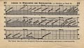
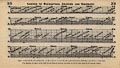
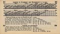
Railway map, strip maps, scale about 1 mile to 1 inch, and
gradient diagrams with descriptive text, Travelling on the
Southern Railway, in the Journey Mile by Mile series, compiled
and published by Stuart N Pike, Shepperton, Middlesex, 1946.
|
|
|
|
private collection (24)
(CTC 1913)
|
Road book, British Road Book, vol II, South West England,
compiled by W Baxter, maps by John Bartholomew and Co, published
for the Cyclists' Touring Club by Thomas Nelson and Sons, London
etc, 1913.
|
|
|
|
private collection (25)
(Bacon 1900s)
|
Road book, road maps and itineraries, Bacon's Up-to-date
Cycling Pocket Road Book of England and Wales, published by G W
Bacon and Co, 127 Strand, London, 1900s.
|
|
|
|
private collection (25_1)
(Bacon 1900s)
|
Road map, uncoloured engraving, Cycling Road Map of England
and Wales, scale about 17 miles to 1 inch, inserted in Bacon's
Up-to-date Cycling Pocket Road Book of England and Wales,
published by G W Bacon and Co, 127 Strand, London, 1900s.
|
|
|
|
private collection (26)
(Harper 1910)
|
Road book, 'The Autocar' Road Book, vol.1 England South of the
Thames, by Charles G Harper, published by Methuen and Co and
Iliffe and Sons, London, 1910.
|
|
|
|
private collection (27)
(Bowles 1763)
|
Map, hand coloured engraving, Modern Map of Hamp Shire ie
Hampshire, scale about 7 miles to 1 inch, published by Carington
Bowles, St Paul's Churchyard, and Robert Sayer, Fleet Street,
London, after 1763.
|
|
|
|
private collection (28)
(Michel and Desnos 1765)
|
Road book, tooled leather binding, Indicateur Fidele ou Guide
des Voyageurs, road maps of France, by Mr Michel, published by Sr
Desnos, Rue St Jacques, Paris, France, 1765.
|
|
|
|
private collection (28_10)
(Michel and Desnos 1765)
|
Road map, hand coloured engraving, Paris to Normandy, Flanders
and London, by Mr Michel, published by Sr Desnos, Rue St Jacques,
Paris, France, 1765.
|
|
|
|
private collection (29)
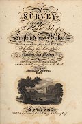
(Mogg 1814)
|
Road book, Survey of the High Roads of England and Wales,
published by Edward Mogg, 51 Charing Cross, London, 1816-17.
|
|
|
|
private collection (29_77)
(Mogg 1814)
|
Strip map, road map, part of route London to Southampton,
Hampshire, scale about 1 inch to 1 mile, published by E Mogg,
London, 1814.
|
|
|
|
private collection (29_EW)
(Mogg 1814)
|
Road map, A New Map of England and Wales, by Edward Mogg, 51
Charing Cross, London, 1817.
|
|
|
|
private collection (30)
(Moll 1718)
|
Road map, hand coloured engraving, The Roads of ye South Part
of Great Britain, ie England and Wales, scale about 33 miles to 1
inch, by Herman Moll, Published by T Bowles, St Paul's
Churchyard, and J Bowles, Cornhill, London, 1718.
|
|
|
|
private collection (31)
(Moll 1718)
|
Strip map, road map, uncoloured engraving, Road from London to
the Lands End, scale about 6 miles to 1 inch, from The Roads of
ye South Part of Great Britain, by Herman Moll, London, 1718.
|
|
|
|
private collection (32)
(Cary 1784)
|
Road book, the Great Post Roads between London and Falmouth,
by A Arrowsmith, 1782, published by John Cary, Arundel Street,
Strand, London, 1784.
|
|
|
|
private collection (32_4)
(Cary 1784)
|
strip map, page 4 from the Great Post Roads between London and
Falmouth, by A Arrowsmith, 1782, published by John Cary, Arundel
Street, Strand, London, 1784.
|
|
|
|
private collection (32_5)
(Cary 1784)
|
strip map, page 5 from the Great Post Roads between London and
Falmouth, by A Arrowsmith, 1782, published by John Cary, Arundel
Street, Strand, London, 1784.
|
|
|
|
private collection (32_6)
(Cary 1784)
|
strip map, page 6 from the Great Post Roads between London and
Falmouth, by A Arrowsmith, 1782, published by John Cary, Arundel
Street, Strand, London, 1784.
|
|
|
|
private collection (32_7)
(Cary 1784)
|
strip map, page 7 from the Great Post Roads between London and
Falmouth, by A Arrowsmith, 1782, published by John Cary, Arundel
Street, Strand, London, 1784.
|
|
|
|
private collection (32_8)
(Cary 1784)
|
strip map, page 8 from the Great Post Roads between London and
Falmouth, by A Arrowsmith, 1782, published by John Cary, Arundel
Street, Strand, London, 1784.
|
|
|
|
private collection (32_9)
(Cary 1784)
|
strip map, page 9 from the Great Post Roads between London and
Falmouth, by A Arrowsmith, 1782, published by John Cary, Arundel
Street, Strand, London, 1784.
|
|
|
|
private collection (32_31)
(Cary 1784)
|
strip map, page 31 from the Great Post Roads between London
and Falmouth, by A Arrowsmith, 1782, published by John Cary,
Arundel Street, Strand, London, 1784.
|
|
|
|
private collection (32_32)
(Cary 1784)
|
strip map, page 32 from the Great Post Roads between London
and Falmouth, by A Arrowsmith, 1782, published by John Cary,
Arundel Street, Strand, London, 1784.
|
|
|
|
private collection (32_33)
(Cary 1784)
|
strip map, page 33 from the Great Post Roads between London
and Falmouth, by A Arrowsmith, 1782, published by John Cary,
Arundel Street, Strand, London, 1784.
|
|
|
|
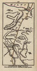
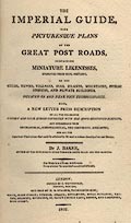
private collection (33)
(Baker 1802)
|
Road book, The Imperial Guide, post roads in England and
Wales, by J Baker, published, London, 1802.
|
|
|
|
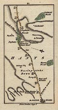
private collection (33_51)
(Baker 1802)
|
Road map, perspective map, part of the Western Road to the
Lands End, in the Imperial Guide, by J Baker, published, London,
1802.
|
|
|
|
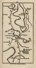
private collection (33_52)
(Baker 1802)
|
Road map, perspective map, uncoloured engraving, part of the
Western Road to the Lands End, in the Imperial Guide, by J Baker,
published, London, 1802.
|
|
|
|
private collection (34)
(Bowles 1782)
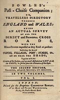
|
Road book, strip maps, Bowles's Post Chaise Companion,
published by Carington Bowles, 69 St Paul's Churchyard, London,
1782.
|
|
|
|
private collection (34_45)
(Bowles 1782)
|
Strip map, road map, uncoloured engraving, part of the London
to the Lands End road, scale about 3.5 miles to 1 inch, published
in Bowles's Post Chaise Companion, by Carington Bowles, 69 St
Paul's Churchyard, London, 1782.
|
|
|
|
private collection (34_61)
(Bowles 1782)
|
Strip map, road map, uncoloured engraving, part of the road
from London to Truro by Barnstaple, scale about 3.5 miles to 1
inch, published in Bowles's Post Chaise Companion, by Carington
Bowles, 69 St Paul's Churchyard, London, 1782.
|
|
|
|
private collection (34_109)
(Bowles 1782)
|
Strip map, road map, uncoloured engraving, part of the road
from London to Weymouth, scale about 3.5 miles to 1 inch,
published in Bowles's Post Chaise Companion, by Carington Bowles,
69 St Paul's Churchyard, London, 1782.
|
|
|
|
private collection (34_195)
(Bowles 1782)
|
Strip map, road map, uncoloured engraving, Canterbury to
Margate, London to Bedford and part of the road from London to
Exeter, scale about 3.5 miles to 1 inch, published in Bowles's
Post Chaise Companion, by Carington Bowles, 69 St Paul's
Churchyard, London, 1782.
|
|
|
|
private collection (34_197)
(Bowles 1782)
|
Strip map, road map, uncoloured engraving, part of the road
from London to Exeter, London to Gosport, and part of the road
from London to Falmouth, scale about 3.5 miles to 1 inch,
published in Bowles's Post Chaise Companion, by Carington Bowles,
69 St Paul's Churchyard, London, 1782.
|
|
|
|
private collection (35)
(Ogilby 1675)
|
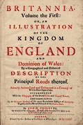
Road map, uncoloured engraving, A New Map of the Kingdom of
England and Dominion of Wales, scale about 26 miles to 1 inch,
general map for the road book Britannia, by John Ogilby, London,
after 1675.
|
|
|
|
private collection (36)
(Hollar 1644)
|
Map, hand coloured engraving, one sheet of Kingdome of England
and Principality of Wales, SE England, scale about 6 miles to 1
inch, engraved by Wenceslaus Hollar, 1644, as published by John
Garrett, by the Royall Exchange, London, 1688.
|
|
|
|
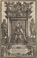
private collection (37)
(Saxton 1575)
|
Frontispiece, uncoloured engraving, for the atlas of the
counties of England and Wales by Christopher Saxton, published
London, 1579.
|
|
|
|
private collection (38)
(Saxton 1579)
|
Map, hand coloured engraving, Anglia ie England and Wales, by
Christopher Saxton, engraved by Augustine Ryther, published in an
atlas of counties, London, 1579.
|
|
|
|
private collection (39)
(Ogilby 1675)
|
Title page, printed in red and black, from an edition of the
road book Britannia, by John Ogilby, London, 1675.
|
|
|
|
private collection (40)
(Black 1870s)
|
Railway map, colour printed, Black's Road and Railway
Travelling Map of England, scale about 14 miles to 1 inch,
engraved by S Hall, published by A and C Black, Edinburgh,
Lothian, early 1870s.
|
|
|
|
private collection (41)
(Luffman 1803)
|
Atlas, county maps, New Pocket Atlas and Geography of England
and Wales, by John Luffman, 28 Little Bell Alley, Coleman Street,
London, published by Lackington, Allen and Co, Temple of the
Muses, Finsbury Square, London, 1806.
|
|
|
|
private collection (41_0)
(Luffman 1803)
|
Map, uncoloured engraving, England, including Wales, general
map in the New Pocket Atlas and Geography of England and Wales,
published by John Luffman, 28 Little Bell Alley, Coleman Street,
London, 1803.
|
|
|
|
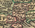
private collection (41_14)
(Luffman 1803)
|
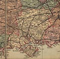
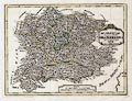
Map, uncoloured engraving, Hampshire, about 37 miles to 1
inch, plate 14 in the New Pocket Atlas and Geography of England
and Wales, published by John Luffman, 28 Little Bell Alley,
Coleman Street, London, 1803.
|
|
|
|
private collection (42)
(Drayton 1612)
|
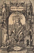
Title page, engraved by William Hole, for Polyolbion, poems by
Michael Drayton, published by M Lownes, J Browne, J Helme, and J
Busbie, London, 1612.
|
|
|
|
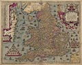
private collection (43)
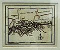
(Gough 1350s-60s)
|
Reproduction map, photozincograph reduced size facsimile,
Gough Map of Britain, scale about 28.5 miles to 1 inch, published
by the Ordnance Survey, Southampton, Hampshire, 1875.
|
|
|
|
private collection (44)
(Luffman 1803)
|
Map, uncoloured engraving, Hampshire, about 37 miles to 1
inch, plate 14 in the New Pocket Atlas and Geography of England
and Wales, published by John Luffman, 28 Little Bell Alley,
Coleman Street, London, 1803.
|
|
|
|
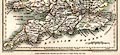
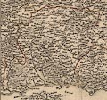
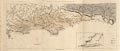
private collection (45)
(Dury 1764)
|
Map, hand coloured engraving, south coast of England, parts of
Dorset, Hampshire, and West Sussex, published by by Andrew Dury,
Dukes Court, London, 1764.
|
|
|
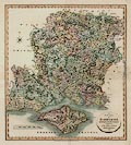
|
private collection (46)
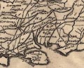
(Carli 1790)
|
Map, hand coloured engraving, Le Provincie che sono al Sud Est
dell'Inghilterra, or the Counties of SE England, scale about 15
miles to 1 inch, published by Pazzini Carli, Sienna, Italy,
1790.
|
|
|
|
private collection (47)
(Carli 1796)
|
Map, hand coloured engraving, Le Provincie che sono al Sud Est
dell'Inghilterra, or the Counties of SE England, scale about 15
miles to 1 inch, published by Pazzini Carli, Sienna, Italy,
1796.
|
|
|
|
private collection (48)
(Langley 1818)
|
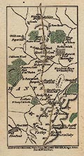
Map, hand coloured engraving, Langley's New Map of Hampshire,
scale about 8.5 miles to 1 inch, published by Langley and Belch,
173 High Street, Borough, London, 1817.
|
|
|
|
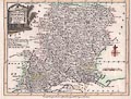
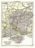
private collection (49)
(Bartholomew 1892)
|
Map, colour printed, Hampshire, scale about 8, by John
Bartholomew and Co, Edinburgh Geographical Institute, Edinburgh,
Lothian, published by A and C Black, London, 1892.
|
|
|
|
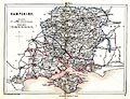
private collection (50)
(Reynolds 1848)
|
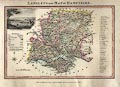
Map, hand coloured engraving, Hampshire, scale about 8 miles
to 1 inch, by John Emslie, published by J Reynolds, 174 Strand,
London, 1848.
|
|
|
|
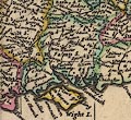
private collection (51)
(Phillips 1814)
|
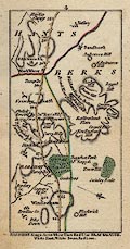
Geological map, Hampshire or Isle of Wight Basin, chalk etc,
scale about 6 miles to 1 inch, published by W Phillips, London,
1814.
|
|
|
|
|
 |
top of page |
|