
|
Catalogue of Map Collection
FA1965 -- FA1997: Identity number order
 |
ACM -- DA |
 |
bottom of page |
|
|
A thumbnail image on the right will enlarge, then return here.
The left link will take you to the Map Collection record page, and if (Map Group) is shown, will link to other Hampshire resources.
If you want to return to your place here, use your back browser button.
|
|
Identity number
(Map Group)
|
|
|
 |
|
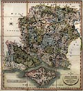
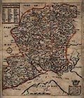
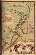
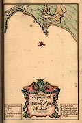
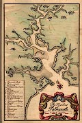
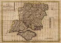
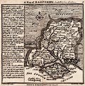
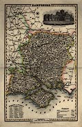
FA1965.589
(Greenwood 1826)

|
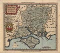
Map, hand coloured steel plate engraving, Map of the County of
Southampton, ie Hampshire, with the Isle of Wight, scale about 1
mile to 1 inch, by C and J Greenwood and Nathaniel L Kentish,
published by Greenwood, Pringle and Co, Regent Street, Pall Mall,
London, 1826.
|
|
|
|
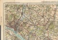
FA1971.424
(OS 1920s Popular Edition)
|
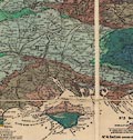
Map, One inch map Popular Edition, sheet 132, Portsmouth and
Southampton, Hampshire, scale 1 mile to 1 inch, published by
Ordnance Survey, Southampton, Hampshire, 1919.
|
|
|
|
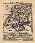
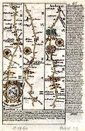
FA1987.7
(Dawson 1832)
|
Map, copy from original hand coloured lithograph, Andover,
scale about 2 miles to 1 inch, Andover, Hampshire, made for the
Reform Bill 1832, by Lieut Robert K Dawson, 1831, copied
1937.
|
|
|
|
FA1987.10.2
|
Map, copy, Portsea Island, Portsmouth, Hampshire, by de la
Fabvolliere, about 1665.
|
|
|
|
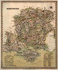
FA1988.3
(Harrison 1788)
|
Map, uncoloured engraving, A Map of Hampshire, county map,
scale about 6 miles to 1 inch, drawn by Haywood, engraved by
Sudlow, published by John Harrison, 115 Newgate Street, London,
16 December 1788.
|
|
|
|
FA1988.4
|
Map, Harmsworth's New Atlas, of the World, published by
Harmsworth, London, about 1914-18.
|
|
|
|
FA1988.5
(Kitchin 1751 small)
|
Map, Hampshire, hand coloured copper plate engraving,
Hampshire and Isle of Wight, scale about 11 miles to 1 inch,
published by Thomas Kitchin, London, about 1751.
|
|
|
|
FA1988.6
(Walker 1837)
|
Map, Hampshire and Isle of Wight, scale about 4 miles to 1
inch, by J and C Walker, 9 Castle Street, Holborn, London, 1837,
published by Longman, Hurst, Rees, Orme and Co, Paternoster Row,
London, 1843.
|
|
|
|
FA1988.7
(Kitchin 1763)
|
Map, uncoloured engraving, A New Map of Hampshire, scale about
7 miles to 1 inch, by Thomas Kitchin, London, published by
Dodsley, London, 1763-64.
|
|
|
|
FA1988.8
(Kitchin 1750)
|
Map, Hampshire, uncoloured copper plate engraving, Hampshire
and Isle of Wight, scale about 9 miles to 1 inch, drawn by Thomas
Kitchin, 1750, published by John Hinton, at the Kings Arms, St
Paul's Churchyard, London, about 1754.
|
|
|
|
FA1988.10
(Baker 1792)
|
Map, uncoloured engraving, Hampshire, with the Isle of Wight,
scale about 7 miles to 1 inch, by Benjamin Baker, Islington,
London, 1792.
|
|
|
|
FA1988.11
|
Map, for a sale catalogue, Longmead, Bishopstoke, Hampshire,
made by Austin and Wyatt, auctioneers, 1928.
|
|
|
|
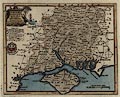
FA1988.26
(Cary 1809b)
|
Map, hand coloured copper plate engraving, A New Map of
Hampshire, with Isle of Wight, scale about 2.5 miles to 1 inch,
by John Cary, 86 St James's Street, London, 1809, edition
published 1825.
|
|
|
|
FA1988.31.1
|
Road atlas, Pratt's Road Atlas of England and Wales, scale
about 6 miles to 1 inch, with index maps, town plans, etc,
published by Anglo-American Oil Co, 36 Queen Anne's Gate, London,
1920.
|
|
|
|
FA1988.31.2
|
Map, Footpaths Map, foot and field paths around Littlehampton,
area in East Sussex and West Sussex, scale 1 inch to 1 mile,
published by Geographia, 55 Fleet Street, London, 1930s?
|
|
|
|
FA1988.31.3
|
Map, Road Map of Great Britain, scale about 16 miles to 1
inch, folded in card cover, published 1930s.
|
|
|
|
FA1988.31.4
|
Map, Avoid the Traffic Road Atlas of Great Britain, scale
about 8 miles to 1 inch, folded pages in card cover, published by
The Autocar, 1956.
|
|
|
|
FA1988.33.2
|
Map, Hayling Island Street Map, Havant, Hampshire, scale about
4 inches to 1 mile, published by Lawrence and Co, Regal House,
Hayling Island, Havant, Hampshire, about 1955.
|
|
|
|
FA1990.1
(LSWR 1905)
|
railway map, colour lithograph, Map of the London and South
Western Railway, southern England, scale about 5.5 miles to 1
inch, published by the LSWR, printed by Waterlow and Sons, London
Wall, London, 1905.
|
|
|
|
FA1990.3.11
(Blaeu 1645)
|
Map, uncoloured engraving, Hantonia, or Southantonensis, or
Hantshire, ie Hampshire and the Isle of Wight, scale about 3.5
miles to 1 inch, by Blaeu, 1645, published by John Blaeu,
Amsterdam, Netherlands, 1662?
|
|
|
|
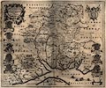
FA1990.11
(Speed 1611)
|
Map, uncoloured engraving, Hantshire described and divided,
Hampshire with part of the Isle of Wight, and a town plan of
Winchester, scale about 4 miles to 1 inch, by John Speed,
engraved by Jodocus Hondius, about 1611.
|
|
|
|
FA1990.20.1
(Kitchin and Jefferys 1749)
|
Map, hand coloured engraving, A Map of Hamp Shire ie
Hampshire, scale about 11 miles to 1 inch, by Thomas Kitchin and
Thomas Jefferys, 1749, published by Robert Sayer et al, London,
1775.
|
|
|
|
FA1990.20.2
(Seller 1694)
|
Map, coloured copper plate engraving, Hampshire, scale about
13 miles to 1 inch, by John Seller, 1694, published with text in
a Supplement to the Antiquities of England and Wales, by Francis
Grose, 1787.
|
|
|
|
FA1990.22
|
Terrier, Terrier of the Netley and Fareham, and Bishops
Waltham Railways, with detail maps at scale about 25 inches to 1
mile, drawn for the London and South Western Railway, LSWR, 1883
and 1862.
|
|
|
|
FA1990.119
|
Map, british and german trench systems, around Moeuvres,
France, Word War I, scale about 3.2 inches to 1 mile, printed by
the Field Survey Company, revised to 1 November 1917.
|
|
|
|
FA1990.148
|
Map, colour printed, Guide Map to the Fareham District,
Hampshire, scale about 4 miles to 1 inch, published by J W
Harding and Co, Sherwood Street, Nottingham, Nottinghamshire,
1920s-30s?
|
|
|
|
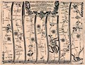
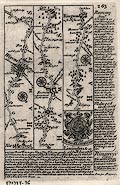
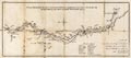
FA1991.5
(Ogilby 1675)
|
Strip map, uncoloured copper plate engraving, road map, part
of The Road From London to the Lands End, scale about 1 inch to 1
mile, from the road book, Britannia, published by John Ogilby,
White Friars, London, 1675.
|
|
|
|
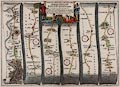
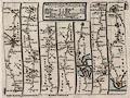
FA1991.6
(Ogilby 1675)
|
Reproduction atlas, road maps, small reproduction edition of
Britannia volume 1, by John Ogilby, 1675, published by Alexander
Duckham and Co, commemorating their 40th birthday, 1939.
|
|
|
|
FA1991.7
(Norden 1595 ms)
|
Reproduction map, colour halftone reproduction of the
manuscript map of Ha'shire ie Hampshire, by John Norden, 1595,
published by Hampshire County Council.
|
|
|
|
FA1991.8
|
Map, ICHNOGRAPHIA OPPIDI AULTONIS, printed copy in early 19th
century of a pen and ink drawing, Alton, Hampshire, scale about
43 inches to 1 mile, perhaps made by IS, 1666.
|
|
|
|
FA1991.9
(Blome 1673)
|
Map, hand coloured etching, A Mapp of Hantshire, ie Hampshire
with the Isle of Wight, scale about 4 miles to 1 inch, by Richard
Blome, about 1673.
|
|
|
|
FA1991.10
(Morden 1695)
|
Map, hand coloured engraving, Hamp Shire, ie Hampshire, scale
about 5 miles to 1 inch, by Robert Morden, published in an
edition of Britannia by William Camden, 1695.
|
|
|
|
FA1991.13.1
(Dawson 1832)
|
Map, hand coloured lithograph, Hampshire, showing the
parliamentary divisions, scale about 6.5 miles to 1 inch, made
for the Reform Bill 1832, by Lieut Robert K Dawson RE, map maker,
1831, copied, 1937.
|
|
|
|
FA1991.13.2
(Dawson 1832)
|
Map, copy of hand coloured lithograph, Christchurch, Dorset
once Hampshire, scale 1 inch to 1 mile, made for the Reform Bill
1832, by Lieut Robert K Dawson, 1831, copied 1937.
|
|
|
|
FA1991.14
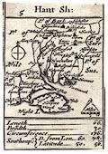
(Morden 1676)
|
Map, uncoloured engraving, Hant Sh, ie Hampshire, with the
Isle of Wight, scale about 27.5 miles to 1 inch, originally the
playing card map by Robert Morden, 1676, published as an atlas
sheet about 1785.
|
|
|
|
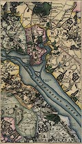
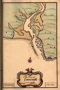
FA1991.16
|
Map, chromolithograph, Plan of Southampton Docks, scale about
17 inches to 1 mile, for the London and South Western Railway,
LSWR, made by T M Williams, Docks and Marine Manager,
Southampton, Hampshire, 1913.
|
|
|
|
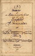
FA1991.24
(Dummer 1698)
|
Report, with charts, A Survey of the Ports on the South West
Coast of England from Dover to the Lands-end, made by Edmund
Dummer and Captain Thomas Wiltshaw, Royal Navy, 1698.
|
|
|
|
FA1991.24.1
(Dummer 1698)
|
Chart, hand coloured manuscript, The Port of Rye, East Sussex,
by Edmund Dummer and Captain Thomas Wiltshaw, Royal Navy,
1698.
|
|
|
|
FA1991.24.2
(Dummer 1698)
|
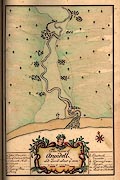
chart, hand coloured manuscript, The Haven of Pemsey ie
Pevensey, East Sussex, by Edmund Dummer and Captain Thomas
Wiltshaw, Royal Navy, 1698.
|
|
|
|
FA1991.24.3
(Dummer 1698)
|
Chart, hand coloured manuscript, The Haven of Cookmere ie
Cuckmere River, East Sussex, by Edmund Dummer and Captain Thomas
Wiltshaw, Royal Navy, 1698.
|
|
|
|
FA1991.24.4
(Dummer 1698)
|
Chart, hand coloured manuscript, The River of New-Haven ie
Newhaven, River Ouse, East Sussex, by Edmund Dummer and Captain
Thomas Wiltshaw, Royal Navy, 1698.
|
|
|
|
FA1991.24.5
(Dummer 1698)
|
Chart, hand coloured manuscript, The River of Shoreham, ie
River Adur, East Sussex, by Edmund Dummer and Captain Thomas
Wiltshaw, Royal Navy, 1698.
|
|
|
|
FA1991.24.6
(Dummer 1698)
|
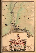
Chart, hand coloured manuscript, The River of Arundell, ie
River Arun, Arundel, East Sussex, by Edmund Dummer and Captain
Thomas Wiltshaw, Royal Navy, 1698.
|
|
|
|
FA1991.24.7
(Dummer 1698)
|
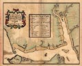
Map, hand coloured manuscript, The River of Southampton, ie
River Test etc, Southampton Water, Hampshire, by Edmund Dummer
and Captain Thomas Wiltshaw, Royal Navy, 1698.
|
|
|
|
FA1991.24.8
(Dummer 1698)
|
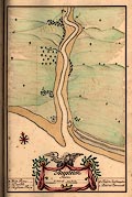
Chart, hand coloured manuscript, The Busselton River, ie River
Hamble, Hamble and Bursledon, Hampshire, by Edmund Dummer and
Captain Thomas Wiltshaw, Royal Navy, 1698.
|
|
|
|
FA1991.24.9
(Dummer 1698)
|
Chart, hand coloured manuscript, The Beauley River, ie
Beaulieu River, Beaulieu, Hampshire, by Edmund Dummer and Captain
Thomas Wiltshaw, Royal Navy, 1698.
|
|
|
|
FA1991.24.10
(Dummer 1698)
|
Chart, hand coloured manuscript, Lymington, Lymington River,
Lymington and Pennington, Hampshire, by Edmund Dummer and Captain
Thomas Wiltshaw, Royal Navy, 1698.
|
|
|
|
FA1991.24.11
(Dummer 1698)
|
Chart, hand coloured manuscript, The Christchurch River, ie
River Avon and River Stour, Christchurch, Dorset, by Edmund
Dummer and Captain Thomas Wiltshaw, Royal Navy, 1698.
|
|
|
|
FA1991.24.12
(Dummer 1698)
|
Chart, hand coloured manuscript, The Haven and Town of Poole,
Dorset, by Edmund Dummer and Captain Thomas Wiltshaw, Royal Navy,
1698.
|
|
|
|
FA1991.24.13
(Dummer 1698)
|
Chart, hand coloured manuscript, The Port of Weymouth and
Melcomb Regis, Weymouth and Portland, Dorset, by Edmund Dummer
and Captain Thomas Wiltshaw, Royal Navy, 1698.
|
|
|
|
FA1991.24.14
(Dummer 1698)
|
Chart, hand coloured manuscript, The River of Exmouth, Devon,
by Edmund Dummer and Captain Thomas Wiltshaw, Royal Navy,
1698.
|
|
|
|
FA1991.24.15
(Dummer 1698)
|
Chart, hand coloured manuscript, The Harbour of Dartmouth,
Devon, by Edmund Dummer and Captain Thomas Wiltshaw, Royal Navy,
1698.
|
|
|
|
FA1991.24.16
(Dummer 1698)
|
Chart, hand coloured manuscript, The Harbour of Fowey,
Cornwall, by Edmund Dummer and Captain Thomas Wiltshaw, Royal
Navy, 1698.
|
|
|
|
FA1991.24.17
(Dummer 1698)
|
Chart, hand coloured manuscript, The Harbour of Falmouth,
Cornwall, by Edmund Dummer and Captain Thomas Wiltshaw, Royal
Navy, 1698.
|
|
|
|
FA1991.44
|
Map, Cyclist's Map of the County of Hampshire, with Isle of
Wight, scale about 4 miles to 1 inch, published by George Philips
and Son, London and Liverpool, Merseyside, about 1920s.
|
|
|
|
FA1991.49
|
Map, Cyclist's Map of the County of Hampshire, with Isle of
Wight, scale about 4 miles to 1 inch, published by George Philip
and Son, London and Liverpool, Merseyside, about 1920s.
|
|
|
|
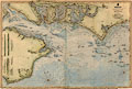
FA1992.1.1
(Sheringham 1840s-50s)
|
Chart, hand coloured engraving, England South Coast, Owers to
Dunnose including Spithead, scale about 1.2 miles to 1 inch,
surveyed by Captain William L Sheringham RN, published by the
Hydrographic Office, 1848.
|
|
|
|
FA1992.166
|
Map, locality of Beaulieu Abbey, Beaulieu, Hampshire, hand
drawn by ? A E Henderson.
|
|
|
|
FA1993.14
(Harrison 1788)
|
Map, palely hand coloured engraving, A Map of Hampshire,
county map, scale about 6 miles to 1 inch, drawn by Haywood,
engraved by Sudlow, published by John Harrison, 115 Newgate
Street, London, 16 December 1788.
|
|
|
|
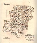
FA1995.32
|
Map, County Series 6 inch map, sheet Hants 57, Hampshire,
published by the Ordnance Survey, Southampton, Hampshire,
1872.
|
|
|
|
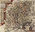
FA1996.22
(Norden 1607)
|
Map, Hamshire olim Pars Belgarum, county map of Hampshire,
scale about 6 miles to 1 inch, by John Norden about 1595, version
engraved by William Hole and published in Britannia, by William
Camden, 6th Latin edition, about 1607.
|
|
|
|
FA1996.33
(Morden 1695)
|
Map, hand coloured engraving, Hamp Shire, ie Hampshire, scale
about 5 miles to 1 inch, by Robert Morden, published in an
edition of Britannia by William Camden, 1695.
|
|
|
|
FA1996.34
(Harrison 1788)
|
Map, hand coloured engraving, A Map of Hampshire, county map,
scale about 6 miles to 1 inch, drawn by Haywood, engraved by
Sudlow, published by John Harrison, 115 Newgate Street, London,
16 December 1788.
|
|
|
|
FA1996.35
(Bowen 1720)
|
Strip map, road map from a road book, Britannia Depicta or
Ogilby Improv'd, text by John Owen, Middle Temple, London, maps
by Emanuel Bowen, published Thomas Bowles, St Paul's Churchyard,
London, 1720 onwards.
|
|
|
|
FA1996.36
(Bowen 1720)
|
Strip map, road map, two sided sheet taken from a road book,
Britannia Depicta or Ogilby Improv'd, text by John Owen, Middle
Temple, London, maps by Emanuel Bowen, published Thomas Bowles,
St Paul's Churchyard, London, 1720 onwards.
|
|
|
|
FA1996.37
(Bowen 1720)
|
Strip map, road map, two sided sheet taken from a road book,
Britannia Depicta or Ogilby Improv'd, text by John Owen, Middle
Temple, London, maps by Emanuel Bowen, published Thomas Bowles,
St Paul's Churchyard, London, 1720 onwards.
|
|
|
|
FA1996.38
(Bowen 1720)
|
Strip map, road map, two sided sheet taken from a road book,
Britannia Depicta or Ogilby Improv'd, text by John Owen, Middle
Temple, London, maps by Emanuel Bowen, published Thomas Bowles,
St Paul's Churchyard, London, 1720 onwards.
|
|
|
|
FA1996.39
|
Map, uncoloured engraving, County Series 25 inch map, sheet
Hants 35.7, Hampshire, published by the Ordnance Survey,
Southampton, Hampshire, 1910.
|
|
|
|
FA1996.40
|
Map, postcard, The Pilgrims' Way, Canterbury, Kent via Sussex,
Surrey, to Winchester, Hampshire, published by Valentine and
Sons, Dundee, Angus, about 1956.
|
|
|
|
FA1997.1
(Morden 1695)
|
Map, uncoloured engraving, Hamp Shire, ie Hampshire, scale
about 4 miles to 1 inch, by Robert Morden, published in an
edition of Britannia by William Camden, 1695.
|
|
|
|
FA1997.2
(Norden 1607)
|
Map, engraving, Hamshire olim Pars Belgarum, county map of
Hampshire, scale about 6 miles to 1 inch, by John Norden about
1595, version engraved by William Hole and published in Camden's
Britannia, 6th Latin edition, about 1607.
|
|
|
|
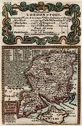
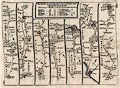
FA1997.3
(Ogilby 1675)
|
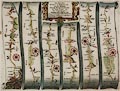
Strip map, uncoloured copper plate engraving, road map, part
of The Road from London to Pool, scale about 1 mile to 1 inch,
from the road book, Britannia, published by John Ogilby, White
Friars, London, 1675.
|
|
|
|
FA1997.5
|
Map, Ordnance Survey, County Series 6 inch, mounted
compilation prepared for Bishops Waltham BC, of sheets for the
area around Bishops Waltham, Hampshire, early 20th century.
|
|
|
|
FA1997.6
(Bowen 1720)
|
Map, road strip map and county map, two sided sheet taken from
a road book, Britannia Depicta or Ogilby Improv'd, text by John
Owen, Middle Temple, London, maps by Emanuel Bowen, 1720,
published Thomas Bowles, St Paul's Churchyard, London, about
1764.
|
|
|
|
FA1997.7
(Ogilby 1675)
|
Strip map, hand coloured copper plate engraving, road map,
part of The Road From London to the Lands End, scale about 1 inch
to 1 mile, from the road book, Britannia, published by John
Ogilby, White Friars, London, 1675.
|
|
|
|
FA1997.8
(Ogilby 1675)
|
Strip map, hand coloured copper plate engraving, road map,
part of The Road From London to Portsmouth, scale about 1 to
63360, 1 inch to 1 mile, from the road book, Britannia, published
by John Ogilby, White Friars, London, 1675.
|
|
|
|
FA1997.9
(Kitchin 1751 small)
|
Map, Hampshire, uncoloured copper plate engraving, Hampshire
and Isle of Wight, scale about 11 miles to 1 inch, by Thomas
Kitchin, London, about 1751.
|
|
|
|
FA1997.10
(Kitchin 1751 small)
|
Map, Hampshire, uncoloured copper plate engraving, Hampshire
and Isle of Wight, scale about 11 miles to 1 inch, by Thomas
Kitchin, London, about 1751.
|
|
|
|
FA1997.44
(Morden 1695)
|
Map, hand coloured engraving, Hamp Shire, ie Hampshire, scale
about 4 miles to 1 inch, by Robert Morden, published in an
edition of Britannia by William Camden, 1695.
|
|
|
|
FA1997.63
|
Map, with route instructions, for journeys in Hampshire,
generated with Autoroute Express software made by Microsoft,
1997.
|
|
|
|
FA1997.64
(Kitchin 1750)
|
Map, Hampshire, hand coloured copper plate engraving,
Hampshire and Isle of Wight, scale about 9 miles to 1 inch, drawn
by Thomas Kitchin, 1750, published by John Hinton, at the Kings
Arms, St Paul's Churchyard, London, about 1754.
|
|
|
|
FA1997.65
(Seller 1694)
|
Map, coloured copper plate engraving, Hampshire, scale about
13 miles to 1 inch, by John Seller, 1694, published with text in
a Supplement to the Antiquities of England and Wales, by Francis
Grose, 1787.
|
|
|
|
FA1997.66
(Seller 1694)
|
Map, coloured copper plate engraving, Hampshire, scale about
13 miles to 1 inch, by John Seller, 1694, published with text in
a Supplement to the Antiquities of England and Wales, by Francis
Grose, 1787.
|
|
|
|
FA1997.67
|
Map, satellite image in realistic colours, Portsmouth area,
Hampshire, made by Rut Gallmeier, University of Portsmouth,
Portsmouth, Hampshire, 1995.
|
|
|
|
FA1997.68
(Seller 1694)
|
Map, coloured copper plate engraving, Hampshire, scale about
13 miles to 1 inch, by John Seller, 1694, published with text in
a Supplement to the Antiquities of England and Wales, by Francis
Grose, 1787.
|
|
|
|
FA1997.69
(Hogg 1784)
|
Map, New Map of Hampshire, scale about 10.5 miles to 1 inch,
Hampshire and the Isle of Wight, published by Alexander Hogg, at
the Kings Arms, 16 Paternoster Row, London, about 1784.
|
|
|
|
FA1997.70
(Hogg 1784)
|
Map, uncoloured engraving, New Map of Hampshire, scale about
10.5 miles to 1 inch, Hampshire and the Isle of Wight, published
by Alexander Hogg, at the Kings Arms, 16 Paternoster Row, London,
about 1784.
|
|
|
|
FA1997.71
|
Map, Environs of Portsmouth, scale about 2 miles to 1 inch,
Portsmouth area, Hampshire, engraved by I Dower, from English
Counties Delineated, published by Thomas Moule, 1837.
|
|
|
|
FA1997.72
(Ramsay 1866)
|
Map, Geological Map of England and Wales, scale about 12 miles
to 1 inch, to by Andrew C Ramsay, Director of the Geological
Survey, published by Edward Stanford, Charing Cross, London,
1866.
|
|
|
|
FA1997.73
(Badeslade 1742)
|
Map, uncoloured engraving, Map of Hampshire South West from
London, scale about 12 miles to 1 inch, Hampshire and the Isle of
Wight, drawn by Thomas Badeslade, published in Chorographia
Britanniae, by William Henry Toms, Union Court, Holborn, London,
1742.
|
|
|
|
FA1997.74
(Badeslade 1742)
|
Map, Map of Hampshire South West from London, scale about 12
miles to 1 inch, Hampshire and the Isle of Wight, drawn by Thomas
Badeslade, published in Chorographia Britanniae, by William Henry
Toms, Union Court, Holborn, London, 1742.
|
|
|
|
FA1997.96
(Bowen 1720)
|
Strip map, road map from a road book, Britannia Depicta or
Ogilby Improv'd, text by John Owen, Middle Temple, London, maps
by Emanuel Bowen, published Thomas Bowles, St Paul's Churchyard,
London, 1720 onwards.
|
|
|
|
FA1997.97
(Senex 1757)
|
Strip map, road map, hand coloured engraving, scale about
2-2.5 miles to 1 inch, The Road from London to Pool in
Dorsetshire, segment from Alresford, Hampshire to Poole, Dorset
and from there to Lymington, Lymington, and from Southampton to
Winchester, Hampshire, and on the other side The Road from London
to Shrewsbury, Meriden, Warwickshire to Shrewsbury, Shropshire
and from there to Welshpool, Montgomeryshire, from a road book by
John Senex, 1719, edition printed for John Bowles and Son, The
Black Horse, Cornhill, London, after 1757.
|
|
|
|
FA1997.98
(Senex 1757)
|
Strip map, road map, hand coloured engraving, scale about
2-2.5 miles to 1 inch, The Road from London to Southampton,
segment from Bagshot, Surrey to Southampton, Hampshire and from
there to Salisbury, Wiltshire, and on the other side The Road
from Exeter to Truro in Cornwall, from a road book by John Senex,
1719, edition printed for John Bowles and Son, The Black Horse,
Cornhill, London, after 1757.
|
|
|
|
FA1997.99
(Senex 1719)
|
Strip map, road map, hand coloured engraving, scale about
2-2.5 miles to 1 inch, The Road from London to Portsmouth,
Hampshire, from a road book published by John Senex, The Globe,
Salisbury Court, Fleet Street, London, 1719.
|
|
|
|
FA1997.100
(Senex 1757)
|
Strip map, road map, hand coloured engraving, scale about
2-2.5 miles to 1 inch, The Road from London to the Lands-End,
Cornwall, segment from London to Andover, Hampshire, and on the
other side the last segment of the road from London to Holyhead,
Anglesey, from a road book by John Senex, 1719, edition printed
for John Bowles and Son, The Black Horse, Cornhill, London, after
1757.
|
|
|
|
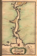
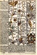
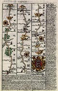
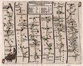
FA1997.101
(Lewis 1831)
|
Map, Southampton, ie Hampshire, scale about 7 miles to 1 inch,
drawn by R Creighton, engraved by J and C Walker, for the
Topographical Dictionary published by Lewis, London? about
1830s-40s?
|
|
|
|
FA1997.102
(Laurie and Whittle 1806)
|
Road map, scale about 7 miles to 1 inch, London to Arundel,
Chichester, etc West Sussex and to Portsmouth etc, Hampshire,
from a road book by Laurie and Whittle, 53 Fleet Street, London,
1806.
|
|
|
|
FA1997.103
|
Feature card, VISIrecord aperture punched card, 9000 holes
numbered according to national grid references with overprinted
map of Hampshire, scale about 7 miles to 1 inch, used for a
project of environmental recording in Hampshire County Council
Museums Service, Winchester, Hampshire, made by Carter-Parratt
Group, Kimpton Road, Sutton, Surrey, about 1980s.
|
|
|
|
FA1997.104
|
Itinerary, on fanfold computer printout paper, various routes
in Hampshire, provided by the Routes Service of the AA,
Automobile Association, Norfolk House, Priestley Road,
Basingstoke, Hampshire, 1997.
|
|
|
|
FA1997.105
|
Guide book, Wessex, About Britain No 2, edited by Geoffrey
Grigson, published for the Festival of Britain Office by Collins,
14 St James Place, London, 1951.
|
|
|
|
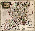
FA1997.106
(Darton 1830s)
|
Map, scale about 4 miles to 1 inch, Hampshire, and the Isle of
Wight, published by William Darton and Son, Holborn Hill, London,
about 1832.
|
|
|
|
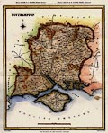
FA1997.107
(Pigot 1828)
|
Map, hand coloured steel plate engraving, Hampshire, and the
Isle of Wight, scale about 6.5 miles to 1 inch, published by
Pigot and Co, 17 Basing Lane, London and 18 Fountain Street,
Manchester, 1828, edition about 1840.
|
|
|
|
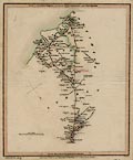
FA1997.108
(Rowe 1816)
|
Map, scale about 4 miles to 1 inch, Hampshire, and the Isle of
Wight, by Robert Rowe, 1816, published by Henry G Teesdale and
Co, 302 Holborn, London, about 1830.
|
|
|
|
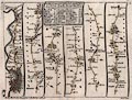
FA1997.109
(Duncan 1833)
|
Map, engraving, New Map of the County of Hampshire, and the
Isle of Wight, scale about 4 miles to 1 inch, published by J
Duncan, Paternoster Row, London, about 1833.
|
|
|
|
FA1997.110
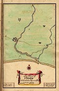
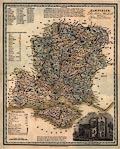
(Greenwood 1826)
|
Map, bound volume of 6 sheets, scale about 1 mile to 1 inch,
Map of the County of Southampton, by C and J Greenwood and
Nathaniel L Kentish, published by Greenwood, Pringle and Co, Pall
Mall, London, 1826.
|
|
|
|
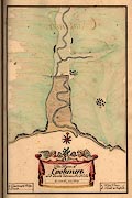
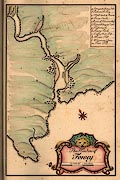
FA1997.111
(Whitworth 1770)
|
Map, uncoloured engraving, Plan of the intended Navigable
Canal from Andover to Redbridge, Southampton, in the County of
Southampton, ie the Andover Canal, Hampshire, scale about 1 mile
to 1 inch, surveyed by Robert Whitworth, engineer, 1770 and
1789.
|
|
|
|
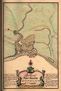
FA1997.112
|
Map, Hampshire, and the Isle of Wight, scale about 14 miles to
1 inch, late 18th early 19th century?
|
|
|
|
FA1997.113
(Harrison 1788)
|
Map, uncoloured engraving, A Map of Hampshire, county map,
scale about 6 miles to 1 inch, drawn by Haywood, engraved by
Sudlow, published by John Harrison, 115 Newgate Street, London,
16 December 1788.
|
|
|
|
FA1997.114
|
Map, coloured copper plate engraving, Isle of Wight, scale
about 4 miles to 1 inch, and part of text about the island, by
John Seller, 1694, published by Francis Grose, about 1787.
|
|
|
|
FA1997.115
(Kitchin 1763)
|
Map, road map, uncoloured engraving, England and Wales, scale
about 1 to 1900000, about 30 miles to 1 inch, by Thomas Kitchin,
published about 1763-64.
|
|
|
|
FA1997.116
(Kitchin 1784)
|
Map, uncoloured engraving, Great Britain, England and Wales,
scale about 27 miles to 1 inch, surveyed by Thomas Kitchin,
publisher in the New and Complete British Traveller, by Walpoole,
1784.
|
|
|
|
FA1997.117
|
Map, uncoloured engraving, Britannia Romana, scale about 40
miles to 1 inch, published about 1830?
|
|
|
|
FA1997.118
(Teesdale 1830)
|
Map, coloured engraving, England and Wales, scale about 18
miles to 1 inch, published by Henry G Teesdale and Co, 302
Holborn, London, about 1830.
|
|
|
|
FA1997.119
(Harrison 1788)
|
Descriptive text, some pages from an atlas of maps of counties
of Great Britain, published by John Harrison, 115 Newgate Street,
London, about 1787-91.
|
|
|
|
FA1997.119.1
|
Map, A Map of Sussex, county map of West Sussex and East
Sussex, published by John Harrison, 115 Newgate Street, London, 1
March 1791.
|
|
|
|
FA1997.119.2
|
Map, A Map of Surry, county map of Surrey, published by John
Harrison, 115 Newgate Street, London, 16 May 1788.
|
|
|
|
FA1997.119.3
|
Map, A Map of Middlesex, county map, published by John
Harrison, 115 Newgate Street, London, 1 September 1787.
|
|
|
|
FA1997.119.4
|
Map, A Map of Berkshire, county map, published by John
Harrison, 115 Newgate Street, London, 14 December 1787.
|
|
|
|
FA1997.119.5
|
Map, A Map of Wiltshire, county map, published by John
Harrison, 115 Newgate Street, London, 11 April 1788.
|
|
|
|
FA1997.119.6
|
Map, A Map of Dorsetshire, county map, published by John
Harrison, 115 Newgate Street, London, 18 June 1789.
|
|
|
|
FA1997.119.7
|
Map, A Map of Somersetshire, county map, published by John
Harrison, 115 Newgate Street, London, 8 March 1790.
|
|
|
|
FA1997.119.8
|
Map, A Map of Devonshire, county map, published by John
Harrison, 115 Newgate Street, London, 2 July 1789.
|
|
|
|
FA1997.119.9
|
Map, A Map of Cornwall, county map, with inset for Scilly
Isles, published by John Harrison, 115 Newgate Street, London, 22
July 1790.
|
|
|
|
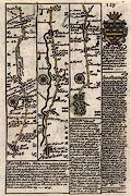
FA1997.120
|
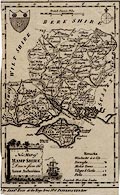
Map, Hampshire, scale about 5 miles to 1 inch, devised by
Donald McCullough, drawn by Ernest Clegg, published by The
Countryman, London, 1947.
|
|
|
|
FA1997.121
(Faden 1796)
|
Map, Hampshire or the County of Southampton, hand coloured
engraving, Hampshire and Isle of Wight, scale about 2.5 miles to
1 inch, one sheet divided into 4 and mounted in a book, published
by William Faden, Charing Cross, London, 1796.
|
|
|
|
FA1997.122
(Hogg 1784)
|
Descriptive text, some pages with maps and prints, from a New
and Complete British Traveller, published by Walpoole, about
1784.
|
|
|
|
FA1997.122.1
(Hogg 1784)
|
Map, engraving, Hampshire, scale about 10.5 miles to 1 inch,
by Alexander Hogg, at the Kings Arms, 16 Paternoster Row, London,
engraved by T Conder, published in New and Complete British
Traveller, by Walpoole, about 1784.
|
|
|
|
FA1997.122.2
|
Print, engraving, View of West Cowes Castle in the Isle of
Wight, engraved by Roberts, from a New and Complete British
Traveller, by Walpoole, published by Alexander Hogg, at the Kings
Arms, 16 Paternoster Row, London, about 1780?
|
|
|
|
FA1997.122.3
|
Print, engraving, View of Carisbrook Castle in the Isle of
Wight, engraved by Roberts, from a New and Complete British
Traveller, by Walpoole, published by Alexander Hogg, at the Kings
Arms, 16 Paternoster Row, London, about 1780?
|
|
|
|
FA1997.122.4
|
Map, engraving, Isles of Guernsey and Jersey, scale about 14
miles to 1 inch, by Alexander Hogg, at the Kings Arms, 16
Paternoster Row, London, engraved by T Conder, published in New
and Complete British Traveller, by Walpoole, about 1780?
|
|
|
|
FA1997.122.5
|
Map, engraving, Isle of Man, scale about 15 miles to 1 inch,
by Alexander Hogg, at the Kings Arms, 16 Paternoster Row, London,
engraved by T Conder, published in New and Complete British
Traveller, by Walpoole, about 1780?
|
|
|
|
FA1997.122.6
|
Map, engraving, Gloucestershire, ie Gloucestershire, scale
about 12 miles to 1 inch, by Alexander Hogg, at the Kings Arms,
16 Paternoster Row, London, engraved by T Conder, published in
New and Complete British Traveller, by Walpoole, about 1780?
|
|
|
|
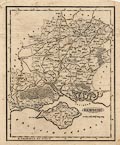
FA1997.123
(Cundee 1815)
|
Descriptive text, about Hampshire, a section from the New
British Traveller, by Dugdale, published 1819?
|
|
|
|
FA1997.123.1
(Cundee 1815)
|
Map, Hampshire, scale about 6 miles to 1 inch, included in the
New British Traveller, by Dugdale, 1819, engraved by Neele,
Strand, London, published by J and J Cundee, Albion Press,
London, 1815.
|
|
|
|
|
 |
top of page |
 |
FA1998 |
|